Modern Singapore stands today, close to 200 years after it came into being as a trading post, as one of the most advanced cities in the world. Icons of the new age now dominate the metropolis, its financial district, much of which came up on land that was made out of marshland and water, is now an amazing maze of glass and steel for which the sky seems the only limit.
Against all of this, it probably will be difficult to imagine Singapore as having been anything other than a city of skyscrapers – even if some fragments of the past are still found within the modern world; certainly not the elegant municipality it seemed to be a century ago as postcards and photographs from the era certainly depict. Having the air, almost, of a European urban centre, the commercial centre of the municipality had by the centenary of its founding, already taken on the appearance of the “great commercial emporium” its founder, Stamford Raffles, had envisioned of it.
Progress has seen that that charming and dignified old Singapore could not survive. The 1950s was probably when the beginning of the end came with the addition of the first “skyscrapers” to the waterfront (interestingly there was an attempt to limit the height of buildings at the waterfront back in the 1920s to a height of 96′ 6″). Much was also to follow, especially in the post independent years and by the 1970s the face of the financial district would drastically be changed. The 1970s also saw substantial amounts of land being reclaimed, creating the land on which Singapore has built its city of future.
Empress Place and Princess Square

The statue of the founder of modern Singapore, Raffles, was moved to (its current location at) Empress Place from the Padang on the occasion of the centenary of British Singapore’s founding. The colonnade seen around it was damaged and removed during the war years.

Another view of Empress Place, with the Fullerton Building (completed 1928) already constructed.

Princess Square – looking up High Street towards Fort Canning Light. The Singapore Cricket Club is on the right and the Hotel de L’Europe stands at the location of old Supreme Court (now part of the National Gallery).
Battery Road / Fullerton Square

Fullerton Square, before the Fullerton Building came up. Part of the first HongKong Bank Chambers can be seen on the left. The Exchange and the old General Post Office on the right is where the Fullerton now stands.

Battery Road, seen with the Tan Kim Seng fountain (since moved to Esplanade Park).

Another view of Battery Road at Fullerton Square. The Medical Hall is where the Straits Trading Building now stands.

Battery Road at the turn of the century. The Dispensary, at the corner of Bonham Street is where 6 Battery Road (Chartered Bank) now stands.

Another view up Battery Road.
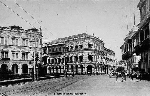
Finlayson Green

Finlayson Green at the turn of the last century. The Straits Times offices can be seen on the left with the offices of the Dutch shipping company Koninklijke Paketvaart Maatshappij on the right along with the three storey headquarters of Behn Meyer.
Another view of Finlayson Green.
Anson Road / Robinson Road

Anson Road, with the once iconic Boustead Institute at the meeting of Anson and Tanjong Pagar Roads.

Robinson Road. The Neo-Classical former Eastern Extension Telegraph Company Building (1927) and part of Telok Ayer market can be seen on the left.

Another view of Robinson Road.
Collyer Quay and the lost waterfront
Built along a bund constructed by convict labour in the mid-1800s, Collyer Quay was completed in 1864 and was soon lined with rather grand looking edifices. By the time the road was widened in the second decade of the 1900s through further reclamation, buildings such as the Alkaff’s Arcade and the five storey St. Helen’s Court had already been erected.
Now around which some of the tallest buildings are found, limits on the height of buildings along the waterfront was a subject of much discussion in the 1920s. In 1921, the Municipal Commission took a decision to limit the height of buildings along the waterfront to 96′ 6″ (about 29.5 metres), the height of St. Helen’s Court. This was to permit “much needed circulation of air at ground”. This was to however be challenged by the architects for soon to be built Union Building, who were successful in having the restrictions relaxed despite objections. One objection raised by John Little’s positioned behind the new building was motivated by a concern that the height of the Union Building would be of “disadvantage and inconvenience to them in the matter of light” (see: The Singapore Free Press and Mercantile Advertiser, 30 January 1922).

Collyer Quay in the late 19th century. The first HongKong and Shanghai Bank chambers (completed in 1892) can be seen at the near end.

A view from the far end of Collyer Quay at Finlayson Green. Princes Building, the 1909 built Alkaff’s Arcade can be seen along with 5 storey St. Helen’s Court. St. Helen’s Court, which was later to be renamed Shell House and subsequently Clifford House after the new 15 storey Shell House was built, was then the tallest building along Collyer Quay.

Collyer Quay in the 1930s, with the second Ocean Building (built in 1924) along with Princes Building, the Arcade, St. Helen’s Court, Union Building (1924) and the Fullerton Building (GPO, 1928) already up. Trolley buses had by that time replaced trams as public transport.

The waterfront in the late 1920s with Johnston’s Pier.

Clifford Pier, built in 1933, in uncluttered settings.

The view of the waterfront from the inner roads with the Union Building, HongKong and Shanghai Bank Chambers and the Fullerton Building.

A view of the Fullerton Road end of the waterfront.

The waterfront in the 1960s. By this time, taller buildings such as the Asia Insurance Building, had already begun to transform the skyline.
The Esplanade

The Esplanade, late 1920s.

Anderson Bridge, when first completed.

Connaught Drive, possibly in the late 1920s.


")


Thank you for that. As late as 1971 the GPO in Fullerton Building would publish a notice to inform of ships’ names and dates / time of closure of outward mail for Europe.
Thanks for that interesting nugget of information Paul! 🙂
Seems like you romanticize the british past of Singapore.
How so?
Thank you for sharing this – I enjoyed your article very much. The achived photos brought back fond memories of my childhood. I remember visits to John Little’s before they opened in the Specialist Shopping Centre (SSC is now defunct I believe?) and trips to MPH at Stamford Road followed by treats of milkshakes at Magnolia Snack Bar with my father and older sister in the ’70s. Such were precious times especially now that my father has passed on and I don’t live in Singapore anymore. Thank you. If you don’t mind, I would like to share this on FB
Hi Irene, I am glad that it brought back nice memories Irene. John Little’s at Raffles Place was one of the places my parents went to get shoes for some reason. Robinson’s was a favourite too – I loved the fabulous toy department there and I loved that old Raffles Place with its underground car park and roof garden. It was so pretty then. Sadly the beginning of the end came with the tragic fire at Robinson’s. I was a regular at MPH too – especially in my school days and yes, who could forget the Magnolia Snack Bar – I still remember the aroma that hit you the moment you opened the heavy door. I would be more than happy for you to share this on FB. 🙂
Jerome, is the MPH building still around? I have been away for quite a while. Fabulous job on putting together and sharing these pics.
Thanks Damien, the MPH Building is still there and is now used by the Singapore Management University (SMU).
Most of these still intact
I love the old buildings. Wish they were some how preserved. Sad.
wonderful glimpses of not too distant past, I recall taking the ferry boat from Clifford Pier with my dad to St. John’s!
An excellent look into the past !
and the destruction of history sadly continues:
http://www.straitstimes.com/singapore/council-of-heritage-practitioners-slams-decision-to-demolish-and-reconstruct-historic?utm_campaign=Echobox&utm_medium=Social&utm_source=Facebook&xtor=CS1-10#link_time=1472871387
Hi Jerome, these photos are amazing. I’m working on a documentary on Singapore identity right now. I need photos like this for the film. Can you please advise where i can get access to such photos? The National Archives? Thank you!
Hi Jeanine, the photos give an entirely different perspective or what Singapore, or at least the municipality / city was like. There was an almost European feel to the city centre up to perpahs the end of the 1960s and it’s sad to see many of the buildings – especially along the bund, go. Many of these are in old postcards and you would also find same or similar images in the National Archives.
Thanks Jerome. Where can I find the postcards please?
Thanks Jerome. Where can I find the postcards please?
There are several sources, such as at collectors’ stores, online, or the Singapore Philatelic Museum shop where you can find them.
An item by Tristram Hunt in last week’s ‘Spectator’, a London current affairs journal (24 September: http://www.spectator.co.uk ), likened Singapore’s Edwardian waterfront architecture as the ‘ Liverpool of the East ‘, apparently this was a colonial nickname for Singapore borne out by its parallel shipping economy.
It was a journey to the past! I could still recognise some of the locations even through the buildings have changed in stages through the years. It would be a good things for young people today to see and know that Singapore was not just mangroves and hints pre-1965!
A bustling metropolis already in 1928, as depicted in an Italian silent film clip:
Has anything been said about a 1819-2019 Raffles commemmoration yet please?
There seems to be some talk about it but nothing much else has been heard.
Thank you Jerome for this article. These buildings are indeed beautiful and very old European feel! It’s unfortunate the elegant buildings are gone. With some foresight, these grand edifices could have been preserved, and the skyscrapers could have been built further away or on reclaimed land, as what cities like Shanghai and Paris have done with Puxi and La Défense
Thanks for your comments Kevin,
It is indeed unfortunate.
Many of these buildings were lost due to the need to redevelop. It wasn’t until land reclamation took place to build the coastal highway the State and City Planning Project (SCP) suggested in 1971 – which effectively was Singapore’s first Concept Plan – that the realisation came that reclamation could be done relatively cheaply to provide space for future expansion of the city. By then, much was already lost.
Lovely piece. Great pics…