An island that always seemed to me to have an air of mystery about it is the oddly shaped Pulau Jong. Set in an area of Singapore, the southern islands, that has much legend attached to it, legend does have it that Pulau Jong or “Junk Island” in Malay, had been a junk that had been transformed by the spirit of the sea into the island. The legend is described by H. T. Haughton in his 1889 paper, Notes on Names of Places in the Island of Singapore and its Vicinity:
Pulau Jong, “junk island”, a small island of a conical shape to the North of Pulau Seking and Pulau Sebarok. The story is that Malay pirates one night attacked a Chinese Junk, which was anchored where the island now is, and just as the Malays got alongside, the Nakhodah of the junk awoke. On seeing the pirates, through terror, he uttered such a frightful yell that the sea-spirit turned the junk into an island much to the consternation of the Malays.

Pulau Jong at sunrise.
Lying east of Pulau Semakau (which has absorbed Pulau Seking or Sakeng) and northwest of Pulau Sebarok, the tiny mound of an island measuring some 0.6 ha., is fringed to its north by some of the deepest waters in the Singapore Strait. From afar, the island looks rather inhospitable – particularly at high tide when only it tiny cliff faces and the clump of trees rising some 23 metres on its mound are exposed. It is at low tide that the fringing reefs that surround the island expose themselves – the reefs extend as far out as 0.4 nautical miles (about 700 metres) south-east in the direction of Pulau Sebarok.
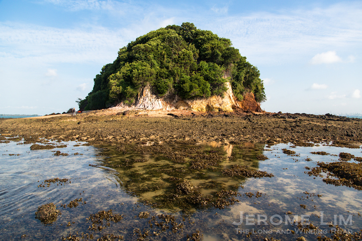
Junk Island at low-tide.

The fringing reef on the island’s south-east reaching out towards the oil terminal at Sebarok.

A navigation chart showing water depths around Pulau Jong.
The reefs do make it difficult to land on the relatively untouched island – one of the last to resist human intervention in the waters of Singapore, but landing on it at sunrise was certainly a worthwhile experience, not just for the rich coral life found in the reefs, but also for the majestic perspectives one gets of the island being on it, the view of all that surround it, and an interesting look at the island’s geology and the glimpses it offers into its bird life.

Heading on a dinghy towards the island.

Landing at sunrise – the reefs do make it a challenge to land safely on the island.

The island’s rock formations are part of the are Jurong Formation that marks the geology of much of Singapore’s west.
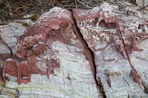
More rock formations …

A pair of collared kingfishers.

And another perched on a rock.
The junk, a very recognisable feature of southern Singapore’s seascape, has long been identified as an island for possible recreational use. More recently however, it does seem from the 2013 Land Use Plan that it would be be lost to future land reclamation. From the plan we see that it would be part of a large land mass that would also include Pulau Semakau and Pulau Sebarok and like the junks that once featured in the seas around us, the familiar sight of the junk that became an island will soon one that is forgotten.

A northward view.

The coral fringed beach looking west towards Pulau Semakau.

Cliff faces on Pulau Jong.
The reef
I didn’t spend much time in the reef, which has some rather nice looking hard and soft corals and sea cucumber. There were also sightings of nudibranchs and flatworms on the reef’s edge. For more posts on what the reef revealed and also a wonderful drone’s eye view of the island, do also check these postings out:


The visit to Pulau Jong is part of a series of visits to some of the lesser known shores of Singapore, in search of words and sounds for an IRememberSG funded project, Points of Departure.

A pano of the southern foreshore of Pulau Jong.


")


Love reading your posts and looking at your pictures. By the way, may i ask what brand and model of camera u are using? Thanks.
Thanks Bai Hu, appreciate your feedback. I am using a Canon 5D MkIII. 🙂
Oh! U are using a Canon. Thanks for the reply. 🙂
How does on get to Pulau Jong?
The best way would be to charter a boat to take you there and back. Alternatively you can keep a look out for kayaking trips that are organised from time to time.
Thank you! I really love reading your blog, especially your posts on old-time Singapore 🙂 Do you know who organises these kayaking trips and also if it possible to know when it is low tide?
Those rock formations are so interesting. Wondering if you’ve had a huge seaweed/algae bloom in the area as in so many other parts of the world this year?
Nice pictures and writing
I’ve seen this island as a kid when we lived on Pulau Bukom in 1963. Once our families took a lighter ( TongKang) for a picnic to an island off the southern end of Bukom. We couldn’t approach the island because the bottom of the lighter was scraping the reefs. Beautiful memories….