Lying somewhat obscurely and hidden at Jalan Kubor off Victoria Street is the Old Malay Cemetery. The cemetery, which is across Jalan Kubor from the Madrasah Aljunied Al-Islamiah Cemetery, another old Muslim cemetery better know perhaps for an incident in 1972 involving two gunmen, is the oldest Malay burial ground in Singapore on record. Quite prominently identified on maps dating from the 1820s and 1830s, it is shown on J. B. Tassin’s Map (Map of The Town and Environs, Singapore) of 1836, as the ‘Tombs of Malayan Princes’.

The burial grounds are described in a heritage trail guide put together by the National Heritage Board (NHB) on Kampong Glam:
MALAY BURIAL GROUNDS AT JALAN KUBOR
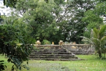
In the early maps of Singapore, these burial grounds were marked as “Mohamedan cemetery” and “Tombs of Malayan Princes”. According to 19th century reports, there were three distinct burial plots here – a 5 1/3 acre Malay cemetery, the 3-acre Sultan’s family burial grounds located within the Malay cemetery and a cemetery for Indian Muslims. In 1875, the municipality closed down the Malay cemetery but agreed to the Sultan’s request that his family could continue to use the royal burial grounds. The sultan’s burial grounds were walled in and the graves were situated in elevated plots. It was noted in the early 20th century that non-Muslims were not allowed to enter them.
More information on the cemetery also came to light during a recent talk by A/Prof Imran bin Tajudeen of the National University of Singapore’s (NUS) Department of Architecture. A synopsis written for the talk also provides some insight into the area and the cemetery:
Several old settlements existed in Singapore besides the Temenggong’s estuarine settlement at Singapore River before Raffles’ arrival in 1819. Among these, Kampung Gelam and the Rochor and Kallang River banks were also sites of historic graveyards related to old settlements of Singapura both before and during colonial rule. The Jalan Kubor cemetery is the only sizable cemetery grounds still largely undisturbed. It belongs with Kampung Gelam history but has been excluded from the “Kampong Glam Conservation District” boundary, and is important for several reasons. It forms part of the old royal port town that was developed when Tengku Long of Riau was installed as Sultan Hussein in Singapore, and is aligned along the royal axis of the town. It is also the final resting place of several traders of diverse ethnicity from the old port towns of our region – neighbouring Riau, Palembang, and Pontianak, as well as Banjarmasin and the Javanese and Bugis ports further afield. Some of these individuals are buried in family enclosures, mausolea, or clusters. Conversely, there are also hundreds of graves of unnamed individuals from Kampung Gelam and surrounding areas. The tombstone forms and epigraphy reflect this immense socio-cultural diversity, and were carved in Kampung Gelam by Javanese and Chinese stone carvers, except for a number of special cases. Several large trees of great age are also found in this lush ‘pocket park’.



















Leave a comment