The view from a reimagined sea … to an earthly abode of the goddess of the sea.
It may be difficult to imagine it now, but there was a time when the sea washed right up to Telok Ayer Street.
Those were times when the street was a landing point. Many who came ashore here would have left home and family to embark on a journey that was filled as much with hope and promise, as it would have been with apprehension and uncertainty.
Coming ashore having survived a passage across tempestuous seas, the newly arrived had much to be grateful for. Shrines placed so homage could be paid to the heavenly beings whose powers of protection had been called upon were a necessary first stop. As the communities grew, in both numbers and wealth, these shrines of gratitude were made more elaborate, and serving as focal points for the communities that erected them.
One such shrine turned elaborate place of worship was the Thian Hock Keng, a focal point for the Hokkien community and the subject of the photograph. Dedicated to the protector of seafarers, Mazu, the temple is a joy to photograph in its various moods.
More on the temple, its activities, and Telok Ayer Street can be found in these posts:
I just uncovered this gem, from an interview that I conducted in 2014 with three sisters, Neng Atini Roslan, Danilah Roslan and Siti Dahlia Roslan.
The Girls of Jalan Saksama, as I called the sisters, had some wonderful stories to share of their experiences in Kangkar Fishing Village and in Jalan Saksama in Changi — two places that we can now only imagine.
With the Girls of Jalan Saksama, an elder sister, and a cousin.
Memories of Kangkar
Our father was a health inspector with the health department. Before Dahlia was born, we lived in a bungalow that belonged to the government, in Kangkar, near Punggol.
Kangkar was a fishing village. There was a fish auction market there, next to our house, and beyond that, a jetty. A police station stood at the end of the road.
There was also a mama (a commonly used Tamil word in reference to an elder or an uncle) prata shop right next to our house. The people who worked there came from India and wore a short sarong that was often pulled up.
The men had left their families back in India. They missed their children and every time they saw us, they would try to hug and kiss us. We never liked it and avoided going into the shop, even when we had to ask to borrow their matches.
The catch was brought in to the fish market very early every morning. Lots of boats came in. Although it was hard to tell from their sun-darkened skins, the fishermen were mainly Chinese. They came from Indonesia and spoke what sounded like Hokkien, or possibly Teochew.
We could see the auction from the balcony of our house, hearing shouts of “sa-chap, sa-chap; see-chap, see-chap; gor-chap, gor-chap” – “thirty (dollars), thirty; forty, forty; fifty, fifty” as the auction progressed. We once saw a huge turtle being sold. It had been turned upside down.
A towkay from the fish market, Mr Png, was very nice to us. He often allowed us to pick the best live fish for free. We could also take dead fish to feed the cat.
We were the only Malays in the village. During a visit there by the then Prime Minister Mr. Lee Kuan Yew, as the only Malay man there, my father was invited to sit next to him.
It was the Chinese neighbours, Mr Png in particular, who helped to protect us during the racial riots. There was a curfew during one outbreak. Our father couldn’t come home and called Mr Png, who came over with the news. He advised us to stay indoors, keep our doors locked and to expect a lot of noise. He also said we would be safe upstairs and gave us some fish to eat.
The riots spread to the village and it was frightening. We could hear the commotion outside, but our mother kept us well hidden on the upper floor of our house. The long stairway of 30 steps that led up could be raised and closed. We kept our heads down so no one would see us.
Mr Png had a son named Tai Seng, whom he had offered to my parents for adoption since there were only girls in our family. At the time, our mother was expecting Danilah and so declined the offer. She thought it would be too taxing to take care of two infants.
With Mr Png and the other Chinese villagers, we communicated in Malay. Everyone spoke some form of Malay then.
The Chinese wayang came to the village during the Chinese festivals. We remember a festival during which we could see the loh-tang, mediums in a trance. They seemed to go crazy and would sometimes chase the children. During that festival, ash would be thrown into the river.
Changi: “The Best Years of Our Lives”
In 1967, we moved from Kangkar to Jalan Saksama near Changi, where our parents bought two acres of land close to Kampong Darat Nanas, behind Changi Prison. The beach was close by, about half an hour’s walk away.
The house that we lived in had already been built when we acquired the land. My father refurbished it and whenever he had money, more rooms would be added. We got our drinking water from a standpipe. Water for other uses such as washing, came from a well.
Unusual as it may have been for Muslims, we had four dogs. They were needed for security. We also kept chickens, geese, turkeys, guinea pigs and even mongoose.
My father planted many trees: forty coconut palms, twenty rambutan, twenty mango and four durian trees. The durian trees only started bearing fruit as we were about to vacate the place. The rambutans were of both the red and yellow varieties. There were also jackfruit, papaya, soursop, custard apple and jambu trees.
We loved climbing the trees. Often, so as to be undisturbed by our dogs and chickens, we would climb a tree to eat nasi lemak, which would be wrapped in a banana leaf. We each also had a favourite tree, from which we would sometimes hang upside down.
There was a Chinese vegetable farm near our house. The farmer also kept pigs. This was perhaps for their manure, which was used as fertilizer. For just five cents the farmer allowed us to pick almost anything we needed from the vegetable plots and often we would take home two to three kilogrammes of vegetables.
From the farm, we also got our supply of fresh eggs, to supplement the eggs our own chickens had laid.
On the left side of our house, there was a sugarcane plantation and also a chiku and rambutan plantation. We would sometimes help ourselves to the fruit, filling baskets we carried with us. Whenever a car passed, we would hide or pretend to be picking grass for the chicken coop.
Our father was the sole breadwinner and whatever he earned went into supporting the family. We had little in terms of luxury and had ice cream only once a month. We bought this at the provision shop that we visited once a week for our grocery shopping.
We purchased groceries on credit. The credit the shopkeeper extended to us was recorded in a little booklet in which we were identified as orang kaya or rich people. It always seemed ironic to us as we owed the shopkeeper money for every item that we purchased. The shopkeeper somehow trusted us. He never failed to deliver the goods on the list our mother prepared, no matter how much we owed him.
The shop was located halfway along the road to the prison, which was in Upper Changi Road. We always had the dog Blackie with us. It was probably because of the dog that the other Malay folk in the village were wary of us. As a result we did not mix with the other Malay children in the village.
There were several other shops at Kampong Darat Nanas. Besides the Malay shop that we got our groceries from, there was also an Indian shop and a Chinese provision shop that was closer to the prison.
For 5 cents we got our supply of ice-balls from the Chinese shop. The ah-pek (a Hokkien word that refers to an elderly man) at the shop never seemed to wash his hands when he made the ice-balls. We never washed ours either and devoured the flavoured ice as fast as we could.
There was a big tree in front of the prison. The top part of the tree seemed to be dead, but the bottom was somehow alive. We called it the “haunted tree”. Everyone from the village seemed to keep well away from it with the exception of the Chinese folk because a Taoist shrine was maintained under the tree.
We were not supposed to go to the beach on our own, but we went whenever we could. This would usually be during the weekends or during the school break. What drew us to the beach was that we could play in the sea. With Blackie always by our side, we headed there on the dirt road that led to the coast.
There was a spring along the way, very close to the sea (this would have been at Ayer Gemuroh). Water gushed out from it and came out of a slope by the side of a road. It was where we could stop to quench our thirst. We never had to carry water with us.
We gained access to the beach from the side of a mosque located by the sea. There seemed to be no access from other areas along the beach because many houses and bungalows had been built there.
Our home in Changi provided us with the best years of our lives. Sadly, we had to leave it behind after living there for about 10 years because the government wanted to acquire the land to build Changi Airport. We were given six months to vacate our home.
The Pain of Moving
We decided to move out early although many of our neighbours stayed on for as long as they could. We did not want to live there without water and electricity, which had already been cut-off.
Since the flat we had applied for in Haig Road wasn’t ready yet, we were provided with temporary housing for three months, so we moved into a very cramped two-bedroom flat in Changi Village. It was rather stressful for us. There was nowhere to run around and we cried all the time.
Our father also had to give the dogs away, to a friend of his who lived on a property with land in Punggol. The dog that we were close to, Blackie, often attempted to look for us.
Once, when we were going visiting in a car, we saw a dog puffing and panting, running along the road. It was Blackie. He had run away from his new master and had somehow found us.
Blackie also looked for Danilah at Bedok Primary School where she went to school. On one occasion she had seen a dog from the bus she had boarded on her way home from school. Danilah recognised Blackie and as soon as she reached her home in Changi Village, she threw her books and her violin down, then took a bus back. Blackie was still waiting for her and when she called and approached, he immediately jumped up on Danilah, who started crying.
At Changi Village, we walked to the beach every morning. We also went fishing. There were plenty of fish to be caught, including ikan tamban (sardine) and ikan selar (yellowtail scad), which we caught without using bait. We would spend hours fishing.
Life was very different when we moved to Haig Road. A lot of adjustment was needed and it took us a long time to adapt.
These days we are spread far and wide, Danilah has moved to the U.S. and Dahlia now resides in Bahrain. We try to come back every Hari Raya and that is when we can reminisce about our days by the sea. We deeply miss the sea and everything about the place we had by the sea. We miss the trees, the dogs, climbing trees, running around, and most of all, the freedom that living there had allowed us.
A page from the Street Directory showing Jalan Saksama in relation to Tanah Merah Besar Road and Changi Prison. A large part of the area is now where Changi Airport is.
The Church of St Joseph at Victoria Street was established by the Portuguese Mission to serve the spiritual needs of the Portuguese / Portuguese Eurasian community in Singapore. Having maintained its ties with Portugal through the colonies of Goa and then Macau, up to 1999 (it came under the jurisdiction of the respective Dioceses until 1981, with the Bishop of Macau making clerical appointments until 1999), it is still where some of the religious traditions of the Iberian peninsula are practiced to this very day.
A procession for the Feast of St Joseph on 19 Mar 2024.
One very visible tradition is the religious procession, which takes place at least once a month and on special occasions. The largest of these processions (in terms of attendance), takes place on Good Friday. That is when the grounds of the church is transformed into a sea of candlelight.
His Eminence, Cardinal William SC Goh, blessing Parochial House.
One procession that took place this week, was held in honour of St Joseph, to whom the church is dedicated to. It was an especially happy occasion for the church as it also coincided with the blessing of Parochial House, which together with the church itself, was closed some 7 years ago for refurbishment. The blessing of the house, the mass and procession that followed was graced by His Eminence Cardinal Willam SC Goh, the Roman Catholic Archbishop of Singapore.
The refurbished Parochial House received its TOP over the weekend.
Senoko Fishery Port, which has its roots in the Teochew run fish businesses of the old Kangkar fishing village at the end of Upper Serangoon Road, has less than two weeks before it shuts for good. Once home to the remnants of Singapore’s fishing fleet, which moved from Kangkar — when it boasted of 90 boats — to Punggol in 1984, before ending up in Senoko in 1997, the so-called port operates in more recent times as a fish wholesale market.
A parting glance at Senoko Fishery Port (1997 to 2024)
Home to a tightly-knit community of 25 traders, the area of the port is intended for redevelopment — word has it that the site will host an expansion of the Micron Semiconductor plant. This will see the displaced fish traders move to the much larger Jurong Fishery Port at which all such businesses will be consolidated.
While the move is welcomed by some, who look towards the larger customer base in Jurong, many others are saddened by their last link to Kangkar’s once famous fishing port, the small but loyal customer base in the north, and the community and the air of friendly competition in which the businesses operated.
For their clients, many of whom are northern base, it also means the time and expense of having to traverse across a much larger distance to obtain supplies.
The fishery port will operate for one last time on 17 March 2024, after which most of the businesses there will move to their new western home.
Lian Yak — which has been in business since 1955 and is the oldest fish trader in Senoko. The company, which operated first in Kangkar, also ran a fleet of fishing boats.
The idea of a “Chinatown” in Singapore, in which there is a large ethnic Chinese majority, seems quite a paradox. There due to its historical connection with the first area of settlement established by way of Singapore’s first town plan in 1822 for the incoming Chinese to the newly established trading post, the area could be thought of as the heart of the descendants of the early Chinese immigrants whose connections in Chinatown include its temples, clan associations and other cultural and religious institutions.
While Chinatown today may have its architectural character preserved through the conservation of many of its streets and shophouses, it does have quite a different flavour. Some say that it has morphed from Chinatown into becoming a “China Town” due to the proliferation of businesses and food outlets catering to the new Chinese community (migrants and new citizens who have arrived post-1990). While that may be so, Chinatown is in the heart of many of the old residents of Chinatown, who continually maintain that connection with it in one way or another.
One former resident, Yip Yew Chong has gone a little further, decorating the walls of Chinatown with murals depicting various bits of its past. For Yew Chong, a prolific mural artist who spent his first 14 years living in a shophouse in Sago Lane and who now maintains a studio in the area, the murals provide an opportunity for old residents of Chinatown, including himself and his family to re-live the past. He also hopes the murals, which incidentally have become popular as instagram-mable spots, will allow other visitors to Chinatown and tourists to find out what life in Chinatown was like back in the days when it served as home to him.
Among the murals Yew Chong has painted, is one “My Chinatown Home”, which as the title suggests, depicts he old home in Sago Lane. Here is a video in which he provides a short description of what he has shown in the mural:
It is hard to imagine it today, but Singapore’s famous main shopping street, Orchard Road, was once lined with car showrooms and motor workshops. Car brands such as Volkswagen, Mercedes Benz, Austin, Morris, Ford, Vauxhall, Fiat … and even Rolls Royce, had a presence there. It was certainly the go-to place to do a test drive and place an order for the still affordable family car, or to send the car for servicing and repair.
Orchard Motors, which was at the corner of Orchard and Bideford Road, became The Orchard in the early 1970s — the home of the (in)famous Tivoli Coffee House (Orchard Motors photo used with the kind permission of Mr Bryan Soh).
Two showrooms that were rather prominent in the regular journeys that I made as a child along Orchard Road between C K Tang and Cold Storage, were Champion Motors and Orchard Motors. Champion, which was then a dealer for Volkswagen is today where Lucky Plaza stands, while Orchard Motors — which dealt with Vauxhalls and Chevrolets, was first converted into The Orchard — a small shopping mall that was better known as the location of the (in)famous Tivoli Coffee House, before being replaced by the Paragon’s original wing.
The Orchard, seen with Lucky Plaza coming up on the site of the former Champion Motors showroom.
Today, only two buildings that bear testament to Orchard Road’s motoring past still stand. One is the wonderfully designed sunburst gabled no 14 to 20 Orchard Road — now used by MDIS, which has a history that goes back to Orchard Road’s early motoring days when it was purpose-built as showroom cum office building for Malayan Motors, a Morris dealer. That stands in a conserved row now opposite Dhoby Ghaut MRT Station — along a stretch of Orchard Road that attracted a host of showrooms and workshops in the early days of motoring and was where Ford motorcars were initially assembled in Singapore. Names such as Universal Cars, a Ford dealer and Borneo Motors, an Austin dealer turned Toyota agent, were also connected with the stretch.
The former Malayan Motors showroom seen in 1984 (courtesy of Henry Cordeiro).
While it does seem quite well established that the former Malayan Motors showroom is still around, much less has been said about Liat Towers, which was constructed as the headquarters and showroom of Mercedes Benz. Its construction came at a time when the street was on the cusp of its transformation into the world-renowned retail destination that it is today. It would not be long before shopping malls such as Plaza Singapura (1974) and Lucky Plaza (1978) launched the transformation of the street into a retail destination.
Once of Jalan Hock Chye, Edmund takes us on a walk back in time from Adelaide in South Australia, to his days as a radiographer in the small and little known Changi Chalet Hospital. The hospital, which was set up in 1974 in the former RAF Changi Chalet Club, became part of Changi Hospital in 1976.
Changi Chalet Hospital
It is surprising what you may accidentally uncover (discover) when you are searching for certain specific items, and how you then get distracted from the task at hand. Usually these surprise discoveries are memory joggers, leading you onto different tangents altogether as they remind you of certain memorable (or unpleasant) times of yesteryear.
I was going through some old photographic slides in the hope of finding slides I wanted to use for a particular project, when I came across two slides that I had forgotten about. And that was it –– my focus was disrupted as I started to reflect on these two images that have withstood the passing of time. Both slides have retained their quality in colour and detail thanks to the arid climate of Adelaide.
One of these slides brought me back to the early 1970s when I was working as a Radiographer I/C at Changi Chalet Hospital. I was also the unofficial resident photographer then and captured memories of staff etc. The slide shows the Nursing staff getting ready for our Christmas Celebration Lunch. The Kodachrome slide processed in Australia was marked as Jan 1975. So I am sure this would be the celebrations of Christmas 1974.
Christmas Staff Party 1974.
On seeing the slide I was then diverted in trying to locate other images of Changi Chalet Hospital. Unfortunately most show the faces of staff members, as such without their permission I am reluctant to share these on the internet. Nor am I known for posting and sharing images of me on the various social media sites with this guest post being an exception.
>In 2015, I did take a trip down memory lane to try and see what changes had taken place since I last worked at the hospital. My, what changes indeed there has been. A good friend drove me there and I was surprised that I could not get my bearings of the area that I was so familiar with, a long time ago. Trying to fit the missing links in my memory banks, I seem to have lost all my bearings.
As we drove slowly along the leafy roads, memories of the squads of SAF commandoes going through their daily exercise drills along the roads, came back to me. Most of all the tranquillity surrounding the old buildings and tall trees and the greenery was striking then and this was still there.
Fond memories of the Chalet Hospital still remain despite being more than 44 years old. It was a “mini” self-contained hospital with a pharmacy, laboratory and radiology services. Workload was not that heavy and I must confess that on a number of occasions when the tide was right I took a dip in the sea during my lunch break.
I was fortunate to be an owner of a second hand green Ford Anglia and used to drive to work from home which was near the start of Tampines Rd and the journey took me to the end of the road then veering left at the junction of the old Changi Air Force Airport into Upper Changi Road. Then after passing the old Changi Village turn left again on to Netheravon Road then into Turnhouse Road.
It was a long drive but almost halfway I used to pick up the Junior Photographic Assistant (my Darkroom Technician) who lived along Tampines Road on the way to work in the mornings and drop him off after work, so I had company for most of the journey to and fro. It was also a long walk from the bus terminus at the Changi Village to the Hospital, so me and other staff who had cars used to pick up other hospital staff who were seen walking to work from the bus stop. It did foster a “family” atmosphere and environment.
As I started this blog thanks to the Onemap Singapore website https://hm.onemap.sg/ I was able to take a walk or rather a “drive” down memory lane. The old maps help put pieces together.
My daily commute from home to work and back (Map from the 1975 Map collection of old maps from the OneMap Singapore website).
There were still sand quarries along Tampines Road then and often you would share the narrow road with lorries carting sand. The spillage from the load of these lorries often presented a road hazard especially after a light shower. The mixture of sand and water was a recipe for skidding. Imprinted in my mind is the sight of the lorry I was trailing do a 360 degree spin. Thankfully I had kept my distance from it and was able to ease off without my car going into a spin too.
Another memory along the route was the turnoff to Kampong Loyang. In my early school days the whole family clan used to spend a week of the August School holidays in a holiday kampong shack in Kampong Loyang. Passing this turnoff always reminded me of those carefree days.
1975 Map showing Kampong Loyang turn off from the OneMap Singapore website.
Part of my duties was to provide x-ray services for the newly established Changi Prison Hospital. So with my JPA I used to drive to the prison on allocated days when x-rays of inmates were requested. The workload was not heavy but the challenges were very different to that of a hospital based X-ray Department. One of the benefits however was the ability to access some of the services of the Prison Industries that were organised to assist in the rehabilitation of inmates by teaching them skills they could utilise on their release and be employable. I remember getting my computer notes and books hardbound for a small sum. And these lasted me for the duration of the Computer studies I was undertaking then and beyond. The hard cover binding was of a professional level.
But the proximity of Changi Village shops was a bonus for us Hospital staff with cars. It was place we frequented for lunch and the occasional shopping. I was just starting into serious photography then and the friendly Photographic shop owner became a great friend. I cannot remember the name of the shop but if my memory serves me well I think his name was Mr Lim. He was a great salesperson and very knowledgeable. I still having gear bought from those days more than 40 years ago. Those were “film” camera days but most of these are still useable though some lenses do need adapters to be used with today’s digital cameras.
Changi Village – map from the OneMap Singapore website.
Recollection of the old Changi Village Shops.
Another memory that resurfaced was the change of plans of upgrading The International Airport at Paya Lebar to the establishment of the current Changi Airport. Driving along Tampines Road we did skirt around the perimeter of the existing Paya Lebar Airport and I do remember seeing the row of terrace houses that were acquired to make way for the initial plan to extend the Airport. These were left vacant after the plans were changed. Likewise there was another beachside newly built hotel along Nicoll Drive, Tanah Merah that was never opened because of the switch to Changi. Most of the hospital staff were looking forward to having a meal at the new premises. This never eventuated. More recently after trying to research the name of the hotel and without coming up with any answers I was beginning to doubt my memory, and wondered if it was a figment of my imagination. However during a recent viewing of this Youtube video https://youtu.be/r26M_Lryu6Y, there was a brief mention of the razing of the hotel. It was great to receive this confirmation indeed.
Changi Chalet Hospital
Main Entrance to Hospital.
? Same Tree – 45 years later.
Panorama of the old “Padang” Sports Field.
Chalet Building erased – sigh………
Fond Memories.
Belonging to the various nostalgia-themed facebook groups has been great for me. There members share photos and experiences of places now mostly all gone. One group I am glad to be part of is the “Memories of Changi Village” group. A “wave” is sent to Ms Geraldine Soh, the administrator. Like the present Changi Airport this fb group platform is the crossroads where members from all corners of the world come together to share their precious memories and photos keeping our own flickering memories of Changi alive.
Katong Park is where a last bastion of a 1870s coastal defence fort, built quite foolishly on sand, can be found. Once fronting the sea, the former defensive position turned recreational space, was also where a bathing pagar – the first to be established by the Municipal Commission for public bathing – was to be found.
Children at the bathing pagar at Katong Park, 1969 (Kim Hocker Collection).
The construction of the pagar – an enclosure extending from the sea shore originally made of wooden stakes – came on the back of the commission’s thrust to provide public facilities for sporting pursuits (see: A short history of public Swimming Pools in Singapore and Parting Glances: the boxing gym at Farrer Park) in the 1920s and 1930s. The original public pagar at Katong was opened by Mr William Bartley in December 1931 – in the same year that Singapore’s first public swimming pool, built using the disused service reservoir at Mount Emily, also opened.
Another view of the pagar in 1969 (Kim Hocker Collection).
Private bathing pagars were especially common then. They were constructed primarily to keep bathers safe and keep the sharks outs and were found at seaside homes and hotels, and at private swimming clubs. A shark attack in 1925, which resulted in the death of an unfortunate bather, Ms Doris Bowyer-Smyth, prompted the Singapore Swimming Club to erect its pagar soon after.
A bathing pagar seen in the sea in front of Beaulieu House, which had been a private seaside residence before it was acquired for the construction of the Naval Base in the 1920s (photo: National Archives of Singapore).
The Chinese Swimming Club’s Bathing Pagar.
The Katong Park pagar, which was concretised in the 1950s, stood until work on reclamation started in 1971. All that now remains to remind us of the seaside – the reason for Katong Park’s coming into being in 1928, is the last bastion of Fort Tanjong Katong.
Fort Tanjong Katong
Among the first set of instructions given by Raffles to Farquhar upon the establishment of Singapore as an East India Company trading post was to have a defensive position in the Tanjong Katong area – at Sandy Point or Tanjong Rhu. The thought of a fort was in fact broached from time to time in reviews conducted of Singapore defences, but it wasn’t until 1878 that a coastal battery at Tanjong Katong would be established with a strengthening of coastal defences in the face of a possible Russian threat.
The sandy base meant that the fort’s high range finding tower moved with each firing, not only requiring a recalibration of the range finders with each firing but also made them impossible to use when the tower shook. The fort, built at sea level, also acquired a reputation for being a “wash-out fort” and was decommission in the early 1900. The fort’s southeast bastion, which were uncovered several times following the conversion of the grounds of the fort into Katong Park were once again uncovered in 2004 and can now be found at a corner of Katong Park.
Fort Tanjong Katong Source: Wellcome Collection (CC BY 4.0)
Fort Tanjong Katong’s southeast bastion.
Another view of Fort Tanjong Katong’s southeast bastion.
Built as government housing by the Public Works Department (PWD) in 1951, the cluster of 42 simple two-storey houses off Haig Road in the news this week, are representative of the period of austerity they were built in. Originally 48 units, arranged in 8 rows of 6 (1 of which has since made way for a road project), their design was a departure from the housing that the government had provided its officers with prior to that. Given a “Class VIII” designation, the two-bedroom units housed junior officers of various departments, including Broadcasting, Civil Aviation, Education, Postal and Telecoms. The quarters line streets named after common trees, Tembusu, Gajus (cashew), Binjai (a type of mango), and Beringin (weeping fig).
A 1951 PWD Photograph.
The construction of the quarters was part of a PWD effort that also saw the erection of three schools over a 12 ha. site. The unique quality of the development was reported by the Singapore Free Press, who in a June 1951 article, made the observation that “there would be nothing like this when it is completed”. The schools that came up with the housing were two primary schools Haig Boys’ School, Haig Girls’ School, and a secondary school, Tanjong Katong Girls ‘s School.
The houses today
The houses have been rented out by the State on short term (2-year) tenancy agreements through managing agent Knight Frank, with 34 units currently tenanted. Despite the short term nature of the arrangements and the age of the properties, the very attractive rents (I have been advised that the median rate is $2700/- per month for the 100 square metre built-up area units) make the houses an appealing proposition. A walk around the neighbourhood will reveal the varied tenant mix this has attracted, as well as the condition that some of the houses are in. Feedback has been given by some tenants on leaking roofs and choked toilets, pipes and drains.
The southern section of Jalan Tembusu.
The Singapore Land Authority (SLA), who maintains the property on behalf of the State, will be carrying out extensive repair and upgrading works from January 2021. This will address the issues raised and ensure that the properties are in good condition for the longer term and will include electrical, plumbing and roof works. SLA has been engaging tenants individually since April 2019 on this, and has permitted an extension to existing tenancy arrangements to the end of 2020. The works are expected to be completed at the end of 2021 and existing tenants who are interested in returning once the works are completed will be able to register their interest to rent the property, which will be let out at prevailing market rates.
Part of the demolished row at the northern section of Jalan Tembusu.
One of the units that is in a relatively better condition.
The southern section of Jalan Tembusu – its proximity to East Coast Road and its shops and eating places also makes the houses an attractive choice for short term rental.
The meeting of Haig Road and the southern section of Jalan Tembusu.
The house have both front yards …
… and back yards that allow tenants to grow fruit tree and daily use items.
One of the since demolished units – seen in 2018.
Another unit from the northern section of Jalan Tembusu. The units feature living and dining spaces at ground level and two bedrooms on the upper level. Access is provided by a well-lit staircase arranged in the extended part of the house.
A vacant unit in relatively good condition.
There are signs of water seepage in quite a few of the units.
Ventilation openings – an essential part of the tropical architecture of old – is very much in evidence.
A look around the unit that is probably in the worst condition among the 42
The inside of a unit that will require a quite a lot of work to be done on it.
There seems a fair bit of water seepage from the roof of this unit – as is evident in the condition of the ceiling boards.
Set in a 50-hectare area that once contained Han Wai Toon’s Silly Fun Garden – or “The Garden of Foolish Indulgences” as coined by Dr. Lai Chee Kien in an essay published in Global History, NParks’ latest nature park – Thomson Nature Park is now opened. Complete with ruins of the Hainanese village of which Mr. Han’s “garden” was an extension of, guests at the park’s opening also included many of its former residents.
The residents included a racing legend Mr. Looi. The Looi’s ran Looi Motors, a motorcycle shop that was located at the current road entrance to the park, along with Thai Handicraft and the family of Mr. Han Wai Toon. More on the Hainanese village, the area’s rambutan orchards and the Silly Fun Garden (where a stash of valuable works of Chinese painter Xu Beihong including “Put Down Your Whip”, which fetched a record price for a Chinese art work of US$9.2 million in 2007 and “Silly Old Man Moves a Mountain“ – sold for US$4.12 million in 2006), can be found at :
With the granddaughter of Han Wai Toon, Rose, who has authored soon-to-be-launched book on Han Wai Toon’s orchard.
Mr Desmond Lee, Minister for Social and Family Development and Second Minister for National Development, with a motorcycle racing legend Mr. Looi, whose family ran Looi Motors, a motorcycle shop and a Thai Handicraft shop close to where the entrance to the park now is.
Bricks salvaged from the remnants of the village, used to cover potholes in the existing road. NParks did as little intervention as possible and repaired the village roads, originally built by the villagers, for use as trail paths.
A blue-rumped parrot seen in the park. The park is rich in fauna and is a key conservation site for the critically endangered Raffles’ Banded Langur.
Entrance to the home of the Hans – the family behind Hans Cake Shop.
It seems that three buildings of the former Singapore Chinese Girls’ School (SCGS) campus at 37 Emerald Hill Road is to be conserved. The campus, used in the interim by Chatsworth International School, features two buildings from the early 20th century as well as the additions of more recent times.
The Song Ong Siang Block, the newest of the buildings that the URA proposes to conserve.
A view over Emerald Hill Road, much of which was gazetted as a conservation area in 1989. The former SCGS was not then included in the conservation area.
The three buildings, assessed to be of high historical and architectural significance, are the Main Block built in 1925, the Principal’s House built in 1930, as well as the Song Ong Siang Block. Built in 1956 and fronting Emerald Hill Road, the Song Ong Siang Block is named after one of the school’s founders, and has served as the face of the school for many. The older buildings were designed by architecture firm Messrs. S. Y. Wong and Co. – the architects for the New World – on English and American principles”.
Once an area in which a jungle of trees that yielded a spice that was worth more than its weight in gold, the area is now dominated by a concrete jungle put to use in mining the gold of the new age.
Founded in 1899, the school occupied a site at the corner of Hill and Coleman Streets (now occupied by the extension to the Central Fire Station) prior to moving to Emerald Hill late in 1925. It is regarded as a pioneer in the provision of education to Straits-born Chinese girls. The Emerald Hill site, previously owned by Dr. Lim Boon Keng, was bought for a sum of 50,000 Straits Dollars in 1924 by the Straits Settlements Government for the school. The school was granted a 99-year lease for the site in exchange for the its Hill Street premises, and occupied the site until it moved to Dunearn Road in 1994.
The 1930’s built Principal’s quarters.
The school, which was renamed Emerald Hill Girls’ School in the early part of the Japanese Occupation, was said to have also been used as a comfort station. This has not been verified, although it is known that several other buildings in the area were put to such use. The Sakura Club, was one known comfort station at Emerald Hill Road. Another, the Nanmei-Soo, which was identified as a comfort station in Goh Sin Tub’s “The Nan-Mei-Su of Emerald Hill, was reportedly more of a ryotei – a restaurant. The Nanmei-Soo reportedly employed hostesses to provide services beyond serving food and drink. This operated out of the ex-Hollandse Club at 30 Cairnhill Road.
The front view of the Main Block, built in 1925.
The decision to conserve the three buildings, comes on the back of a community effort driven by former students of SCGS, “Keep 37 Emerald Hill“. The effort saw various proposals put forward for the reuse of the buildings in a manner that the history of the site is not lost.
The main block as seen from the back.
Another view of the front of the Main Block.
The Song Ong Siang Block.
The Main Block as seen from the Song Ong Siang Block. The Lee Kong Chian Block, an addition in the 1970s seen on the right of the Main Block is not one of the three being proposed for conservation.
Stairway in – if I remember correctly – the Song Ong Siang Block.
Those familiar with Moulmein Road in the days of Moulmein Green would remember the old Middleton Hospital and its iconic gatehouse. The landmark entrance-way stood for over 70 years before “progress” swallowed it up in the 1980s. Progress, which came in the form of road realignment and widening as part of the construction of the Central Expressway (CTE), saw also to the demise of Moulmein Green – one of at least a couple of roundabouts that were named “Green” (the other was Finlayson Green).
The gatehouse with the black lion crest on it and a bit of Moulmein Green in the foreground.
The gatehouse provided both the hospital and the area with an identity that went beyond being a physical presence. It was the hospital’s black lion crest, which was on prominent display on the house, that the area’s name in the Hokkien vernacular came from.
The black lion – seen at the entrance of the former CDC.
The structure’s disappearance came at about the same time that Middleton, a name that the infectious diseases hospital was known as for 75 years, was also lost. Morphing in Tan Tock Seng Hospital’s Department of Communicable Diseases in 1985 and in 1992 the Communicable Diseases Centre (CDC) however, did not stop the former hospital from being in the news. It was a key component in the health plan drawn up in early days of the AIDS epidemic that saw a dedicated AIDS ward set up in April 1986. The CDC, which for a period of 3 years until 1995 functioned independently of Tan Tock Seng Hospital, has also been at the forefront in the battle against several other high-profile disease outbreaks, such as the 2003 SARS epidemic.
Structures belonging to the former Middleton Hospital.
The absence of the gatehouse has also allowed a much clearer view of the centre’s expansive grounds and the quaint old structures seen on it. The sight is one that is increasing rare in Singapore and provides a glimpse of what could be thought of as an old-fashioned bit of Singapore that we should be thankful to the continued operation of the CDC for.
The old laundry.
It was an old-fashioned and a very different Singapore into which the former hospital came into being. With many in the already overcrowded municipality’s rapidly increasing urban population living in quite insanitary conditions, the urban centre was rife with highly contagious and often deadly diseases. Containing the spread of them, especially among the largely ignorant townsfolk, posed a huge challenge.
The wards of the new Tan Tock Seng Hospital. Overworked medical staff from the hospital, which was also in Balestier Road before moving to their new site at Moulmein, provided care for the poor also attended to patients at the smallpox hospital and quarantine camp.
The former hospital’s origins can be traced back to a smallpox hospital that was established in the early 1870s at Balestier Plain (where the Singapore Singapore Indian Association and its sports fields are now located). This was expanded with a quarantine camp to isolate and confine “natives” afflicted with other infectious diseases on an adjacent site. Overworked doctors from nearby Tan Tock Seng attended also to patients at the camp.
An 1893 Map showing the Smallpox Hospital and also a Leper Asylum in Balestier Plain (National Archives of Singapore).
A 1905 Map showing the smallpox hospital and the infectious diseases ward (National Archives of Singapore).
By the turn of the last century, it became apparent that the hospital/quarantine camp “was unfit to meet the requirements of a large population liable to epidemics of smallpox and cholera and, to a less extent, of plague”. In 1905, plans were put forward by the Municipal Commission to erect an Infectious Disease Hospital at Moulmein Road. This would also provide wards for Europeans (not without objection), as well as “better class natives”. It wasn’t however until 1911 that work on a scaled-down version of the new hospital began in earnest.
Commissioned on 1 June 1913, the $270,000/- 172-bedded Infectious Diseases Hospital was described as being a “little more than the bones of what was proposed”. It was an improvement however to the “ramshackle institution in Balestier Road” that it replaced. Spread over an 11.5 hectare site, the facility featured three camps for the isolation and confinement of patients infected with cholera, plague and smallpox.
There were originally three clusters of pavilion wards – all widely spaced from each other – “camps” encircled by a fence.
The gentle rising slope that the hospital was placed on, provided for drainage. A fence, a triple-fence on three sides and an iron fence along Moulmein Road, encircled the hospital. This was as much to keep the general public out as it was to keep patients in. The gatehouse provided the hospital with a “pre-processing gateway” with lodgings for the gatekeeper / caretaker on the upper level.
The “pre-processing gateway” – with caretaker’s lodgings above.
Going past the gatehouse one would have seen the doctors and nurses quarters on the right, with those for other staff on the left. An administrative building was positioned right up the road. Three six-bedded wards were placed some distance away to its left with another three on its right. These were for observation and discharge.
What probably were the nurses quarters.
The camps, each enclosed by a fence, were found further up the road past the administrative building. The plague camp was arranged on the left, the cholera camp on the right, and the smallpox camp at the back at the top of the slope. The camps featured a ward for “natives” with extensions to accommodate “better class natives”. “Europeans” were housed separately.
The administrative building.
The old-fashioned concept of infection control through separation and ample (natural) ventilation that resulted in the layout of the hospital and in the design of its wards is very much in evidence in the CDC’s pavilion-style wards, even if they may have been modified. Air-conditioning, for both comfort and infection control, is one modern day addition. Building materials and fittings containing asbestos must also have been replaced. These would have been found in the Eternit ceiling panels that were fitted for insulation, damp and vermin control, and fire resistance.
Features for natural light and ventilation are found on the older ward buildings.
With the CDC moving to its new home last December where it has taken on a new identity as the National Centre for Infectious Diseases or NCID, time is being called on the former hospital. The site is marked for residential development under the URA Master Plan and it would probably not be long before all evidence of the hospital and its buildings is erased.
In the Master Plan.
Another former ward building.
Many of the former CDC’s buildings do actually go back to its days as the Infectious Diseases Hospital of 1913, including the administrative building, a stand-alone mortuary building, and the laundry in its southeastern corner. The laundry, which was expanded postwar with the addition of a new building, was designed such that dhobis would not have had to handle the items to be laundered until they were properly disinfected and cleaned. There are also some of the original wards – Singapore’s last pavilion wards to remain in use and former quarters.
The mortuary.
Possibly one of the original observation or discharge wards.
With the old hospital having passed into history, it also is important not to forget those associated with its past. Prof. Ernest Steven Monteiro is one who comes to mind whose pioneering in preventive medicine Singapore must be thankful for. Dr. Monteiro is credited with initiating what turned out to be a very successful mass vaccination campaign against polio in the the late 1950s.
The front of the mortuary.
Dr. Monteiro connection with the hospital was during the Japanese Occupation. As the Japanese appointed director of the then Densen Byoin, which was teeming with sick people with infectious diseases such as typhoid and ailments brought about through malnutrition, the young director faced many challenges. One especially serious one was the shortage of anti-diphtheria serum, which he overcame through improvisation. His son, Dr. Edmund Monteiro, was to make significant contributions to Middleton Hospital and the CDC during his service there from 1965 to 1993. The younger Dr. Monteiro’s oversaw the hospital’s transition to the CDC and co-ordinated the CDC’s response to the HIV/AIDS epidemic.
Ward 76, which was converted for use as a HIV/AIDS ward.
We should also remember the forgotten Dr. William Robert Colvin Middleton, after whom the hospital was named in 1920 upon his retirement. This was to recognise the many contributions he made as one of Singapore’s longest serving Municipal Health Officers to improving lives and the role he played in the setting the hospital at Moulmein Road up. A short bio on Dr. Middleton can be found at the end of this post.
A visible part of the CDC today – former quarters.
The newer extension to the laundry.
Emergency wards set up for SARS.
An isolation room in the emergency wards.
A look inside one of the former wards.
A much more modern addition, a negative pressure ward.
(The forgotten) Dr. W. R. C. Middleton, Municipal Health Officer, 1894 to 1920
A painting of Dr. Middleton, one of three portraits painted by Anatole Shister for display in the Chief Committee Room of the new Municipal Building (later City Hall) in 1929 (National Collection as listed on roots.sg).
The son of a Church of Scotland Minister and a military chaplain in India, Dr. William Robert Colvin Middleton was born in Bombay in 1863. Having obtained his medical qualifications in 1888, he served as a resident physician in the Aberdeen Royal Infirmary before heading to Singapore in 1890 to work for Dr. Charles Llewellyn Howard Tripp in the Maynard and Co. Dispensary.
Dr. Middleton applied for the position of Municipal Health Officer in late 1893 when its became vacant due to the resignation of Dr. Charles Eardley Dumbleton. Dr. Middleton was given the appointment of Acting Health Officer in January 1894 with a view to the full post, on the condition that he obtain a Diploma in Public Health; the Municipal Commission had then determined that should be a prerequisite for the position. Dr. Middleton left for Aberdeen at the end of March that year, returning with the required Diploma in October, all at his own expense!
Dr. Middleton held the appointment of Municipal Health Office upon his return until his retirement late in 1920, except for a spell back home in during the Great War in 1916. He survived the torpedo attack on the ill-fated RMS Arabia, which sunk in the Mediterranean in November 1916, on his passage back to Singapore from this.
Besides the numerous contributions he made improving the state of sanitation in Singapore, as well as in other aspects of public health including in maternal care, Dr. Middleton also served as the Deputy President of the Municipal Commission in 1904. He held the rank of Major in the Singapore Volunteer Corps and was credited with setting a medical aid post up on the P & O wharf during Singapore Mutiny for the transfer of casualties to the military hospital on Pulau Blakang Mati.
He passed away at the age of 58, on 8 December 1921, in Bexhill in Sussex. He was survived by his wife, the former Mrs. Ethel Hunt, whom he married at St. Andrew’s Cathedral in April 1909.
I enjoy visiting Kuala Lumpur for a variety of reasons. The Malaysian capital, known by its acronym KL to most, provides me with a sense of having returned home home in a way that home – some 200 miles away in Singapore – is no longer able to do.
An old market in KL.
It would seem strange, if not for the history Malaysia and Singapore shares and perhaps, for the frequent visits I have made to KL since I was a child. In the bits of the past, found in the modern of the bustling metropolis, I especially find joy in. The disorder of their shophouses, the clutter along the five-foot-ways, the colours and smells of old street markets and old coffee shops, are that reminder of the Singapore that I grew to love as a child that I would never otherwise be able to ever see again.
Lunch time at Lai Foong.
An old coffee shop that I remember from my childhood visits to the city, the Kedai Kopi Lai Foong, is one such reminder. An institution in a city in which there is no shortage of such old gems, the 1950s coffee shop seems little changed from the 1970s and is quite reminiscent of the busy urban centre coffee shops of Singapore’s lost past.
Mirror, mirror on the mosaic wall. Mirrors were commonly given as opening gifts at coffee shops in Malaysia. Mosiac or kitchen tiles were commonly used on the walls of coffee shops both in Singapore and Malaysia as they could be easily cleaned and did not require frequent repainting.
Positioned at the corner of Jalan Tun H. S. Lee and Jalan Tun Tan Cheng Lock, it sits just across Jalan Tun Tan Cheng Lock from Petaling Street (or Chinatown). That and its proximity to Central Market – now the touristy Pasar Seni, has meant that the coffee shop has long attracted more than its fair share of the local crowd as well as a steady stream of out-of-town visitors. With Tripadvisor now inflating the number of would be visitors, any attempt to seat oneself in the confusion of tables and chairs in the shop’s confines, presents quite a challenge. Any intent to savour some of the coffee shop’s famous fare must now be accompanied by the patience of a saint, some guile, and most of all, a fair bit of luck; all of which I must have had when visited the coffee shop for a bowl of its much-talked about beef noodles back in June.
A scene reminiscent of the coffee shops of old Singapore, with its stalls lining the outer edge of the shop.
A posting I made on Facebook of the bowl of beef noodles invited a comment from a locally based acquaintance, in which a recommendation was made to have the wanton mee at Kedai Makanan Toong Kwoon Chye, another old kopitiam. With its location along Jalan Bukit Bintang also presenting me with an opportunity to reacquaint myself with an area of KL that I had lost touch with, there was enough of a motivation for me to hop on the MRT to Bukit Bintang, just a few days later.
Kedai Makanan Toong Kwoon Chye.
Despite the familiarity I had with the area, I had no impression at all of Toong Kwoon Chye prior to my June visit. I found it quite easily, tucked away in a quiet corner of the street. It might have been the time of the day but even if it was of a similar vintage to Lai Foong, Toong Kwoon Chye couldn’t have been more different. There was absolutely none of Lai Foong’s rush and time, seemed to slow to a standstill, the moment that I stepped into the coffee shop.
Furnished in what may be described as the classical kopitiam style, with marble topped tables and wooden chairs – sans the spittoons of course – Toong Kwoon Chye’s old coffee shop feel was made complete by its counter, even if it was somewhat more modern in looks than one might have expected. Just like any old coffee shop of the good old days, a row of clear-glass jars with red covers stood at one end, half filled with biscuits and other snacks for sale. With so much of a sleepy old out-of-town kopitiam vibe about it, it seemed fitting for me to while the morning away sipping on a cup of coffee and take the time to savour the plate of shredded chicken noodles that I had ordered.
The ebb and flow at Toong Kwoon Chye.
The lazy breakfast put me in the mood for an unhurried stroll, which first took me inside Sungai Wang Plaza. It was one of two interconnected malls from the 1970s I never failed to visit whenever I find myself in the area. The other, which I liked better, was Bukit Bintang Plaza. That has since made way for redevelopment. With little to distract me in Sungai Wang, I decided to continue my stroll outdoors instead and soon found myself retracing footsteps I must have last made some four decades past.
The changing face of Jalan Bukit Bintang – now missing BB Plaza.
The familiarity I had with Bukit Bintang had come out of numerous family holiday stopovers in KL. Holidays abroad in my childhood, with the exception of a visit to Thailand in 1978, invariably meant road trips across the Causeway. KL, a six-hour drive before the North-South Highway made drives a breeze, served as a break-journey point on the road up to more northerly destinations such as Cameron Highlands and Fraser’s Hill (at which the Singapore Government maintained holiday facilities for civil servants). The combination of affordable accommodation, shopping and food in Bukit Bintang, made it a good location to put up in.
Tong Shin Terrace.
One of the things we must have done with sufficient regularity, for me to have remembered them in such vivid detail, were the walks to Chinatown. That took us down Jalan Alor or Tong Shin Terrace, and then west along Jalan Pudu. Both Jalan Alor and Tong Shin Terrace seemed to have retained much of their character, although I am told that Jalan Alor’s well patronised nighttime eateries now cater to quite a different crowd.
I found myself taking a little detour into the area’s back lanes, perhaps in the hope of finding a nasi lemak stall that we had stumbled upon during a June 1979 sojourn in KL. That visit to KL was one to remember for several reasons. It provided me with my first experience as a football spectator outside of Singapore. The match that I caught was also one of huge importance to the Singaporean football fan of the 1970s, the Malaysia Cup final.
The back lanes around Tengkat Tong Shin.
The final, played at KL’s Stadium Merdeka, saw Singapore take on a Selangor team that featured Malaysian footballing legends such as Mokhtar Dahari, R. Arumugam and Santokh Singh. The final that year was significant for the debut of the talented Fandi Ahmad, who was also playing in the competition for the first time. Fandi, then 17, would go on to illuminate the competition in which Malaysian state teams and Singapore featured.
STadium Merdeka today, surrounded by a development that is seeing the rise of Malaysia’s tallest building, a 118-storey tower that will also be the third tallest in the world.
As the match coincided with a trip we were making, we were able to obtain tickets at the stadium when they went on sale. That made it all the more memorable, as it meant that we were seated in a section occupied by the crowd of boisterous home supporters in a match in which controversial 66th minute Selangor goal proved to be a turning point. Mokhtar would add a second to complete a two goal victory for Selangor but all that is another story. What would also make that trip one to be remembered was the joy of discovering nasi lemak at its simplest, served at a makeshift stall.
A courtyard hotel.
There no nasi lemak to be found this time, not at least the manner in which that was served. However, the back lanes yielded several new discoveries. Spruced up and a lot less familiar, they now feature brightly painted wall murals, modern eateries and a very nice looking courtyard hotel.
A back lane eatery.
Back out from the back lanes, it all became familiar once more down Tong Shin Terrace. An old block of flats, which I had always assumed to have been a low-cost housing development, came into view. I therefore was quite surprised to learn with Google’s help that the development, the Blue Boy Mansion, was thought of as a landmark development when it was erected back in 1962.
The Blue Boy Mansion.
Inside the Blue Boy Mansion.
West from from Blue Boy Mansion along Jalan Pudu, just past Tung Shin Hospital was another familiar sight. Now in disguise as the modern looking Pudu Sentral, it was unmistakably Puduraya, for a long while KL’s main bus station. The station now sees just a fraction of the bus services that used to operate out of it. I realised how time has flown by in attempting to recall when I last took a bus out of the station. That was a trip to made in the mid-1990s to Kuala Kubu Bharu to catch another bus up to Fraser’s Hill.
Hitting Pudu Sentral meant that I was closing in on Chinatown. As there was still time to spare, I decided to make my way to Lai Foong in the hope of satisfying an urge I was having for its char kway teow, only to find the stall closed. The disappointment of that, coupled with the rising heat and humid of the mid-June Klang Valley afternoon, made the lure of modern KL – in the form of an air-conditioned mall – hard to resist. I soon found myself in one to cool off and then have a late lunch, before I headed back to Petaling Jaya where I was putting up.
I love wandering around the “kaki lima” or five-foot-ways of old Kuala Lumpur. Full of life and character, they remind me of the lively and colourful five-foot-ways of the Singapore of my younger days.
The corridors are found along the Malaysian capital’s many old shophouses. Seen also in most towns and cities across Malaysia and also in Singapore, the five-foot-ways (not necessary five feet wide) trace their existence to the Jackson (Singapore) Town Plan of 1822. The plan, which Raffles had a hand in, required that “all houses constructed of brick or tile should have a uniform type of front, each having a verandah of a certain depth, open at all times as a continuous and covered passage on each side of the street”.
The photographs of the site of the former National Aerated Water Co. used in this post were taken during a private visit organised by the Urban Redevelopment Authority (URA) for invited guests and have been used with the kind permission of the site’s current owner. Do note that the site is not opened to the public.
Disused spaces bring great joy, even as in the case of the former National Aerated Water Co’s bottling plant at 3MS Serangoon Road, the paraphernalia associated its use has long been removed. There is much to learn from the spaces, especially those that were conceived with little in way of frills in an age of greater simplicity. The disused plant, fronted by an art-deco-esque tw0-strorey structure placed along a thoroughfare that would have been hard to miss, last saw use some two decades ago. Associated with the bottling of two popular soft-drink labels, Sinalco and the joy in a green bottle that was the comic strip inspired Kickapoo Joy Juice, there are many now who look back fondly at the now empty building that is one of few constants in an area that has seen much change.
The art-deco front of the former factory is a rare constant in an area that has seen much change.
The good news we heard just last week was that a portion of the former plant – its front – is being conserved. Selangor Dredging purchased the site for residential redevelopment just last year and has over the year been working with the URA on the conservation of the former plant’s most recognisable feature and its face – the art-deco main building.
The disused factory offers us a window into the past.
The factory, of a 1954 vintage, last saw operations some two decades ago. Built at a time of increasing demand for soft drinks, the home-grown company’s new plant found immediate success. The investment in the state-of-the-art factory and bottling equipment on the company’s 25th Anniversary was motivated by Sinalco’s 1952 award of exclusive bottling and distribution rights. An interesting nugget of information was shared by the URA about the rather peculiar name of the German drink was that it was derived from the words “sine alcohol” or without (in Latin) alcohol. More on the plant and the company can be found in a previous post: Losing its fizz: the third milestone without the former National Aerated Water plant.
Writings on the wall: soft drinks bottled at the plant … plus a secret formula perhaps.
The L-shaped building being conserved was where the company was run from. Offices and a mixing room were located on the upper floor and a reception, the storage area and distribution spaces on the lower level. The conserved building has several interesting features. These include a purpose designed “signage tower” on which the Sinalco logo was emblazoned, a tapering balcony at the front with a fair-faced brick parapet facing the road on which the company’s name is mounted, and a built-in sun shade projecting out from the building’s side that spirals out of a circular window (see: Conserved features of the building at “Former National Aerated Water Factory building to be gazetted for conservation” identified by URA). Parts of the building will have to be rebuilt. This includes the southeast corner, which will have to be knocked-down to permit vehicular entry to the site for construction.
A sun shade or concrete, spiraling out of a circular window.
The signage tower.
Office space on the upper floor.
Redevelopment will take place on the site just to the rear of the conserved building and this will see several structures removed, including the wide-span steel truss supported roof structure under which the main shopfloor of the plant was sited. This roof construction, topped with corrugated roofing sheets, has ample window covered openings built in to it to maxmise the entry of light and ventilation. An auxiliary building, that would have contained service spaces including toilets that can still be seen, can be found close to the rear perimeter of the site.
The shopfloor and the roof structure through which light into the factory was maximised.
The building at the rear of the site.
A look around …
A last reflection. The reception area at the southeast side of the building.
The fair-faced brick parapet.
Windows from the past into the present.
The main staircase.
The tapered front facing balcony.
The rear of the office space – which overlooked the shopfloor. Part of the roof structure can be seen.
Timber doors and matching ventilation grilles above are seen on the outward facing boundaries of the main building.
A view from the former shopfloor towards the main building. The right portion of the building was where crates of soft drinks were stored and dispatched.
The southwest side of the building.
The part of the building that will be reconstructed.
The office space on the upper floor.
The mixing room.
Joyful switches.
A view out the back of the office space towards the roof and the shopfloor below.
A close-up of the corrugated roofing sheets.
Frosted or textured glass is in evidence throughout to filter light that would otherwise have been too harsh.
Close-up of a textured glass panel.
Up on the roof.
A view over the top.
Textured glass windows.
A ventilation house?
Dead slow ahead. The part of the factory that will be demolished as seen from the driveway.
The pump at the driveway, which is visible from the outside.
Notices in the back pages of the press can sometimes bring joy.
An notice that gave me a sense of happiness appeared in today’s edition of the Straits Times, which contained a list of proposed amendments to the Master Plan being made by the Urban Redevelopment Authority (URA). One is the re-designation of part of a certain Lot 05052P, Mukim 17 at Serangoon Road as a Conservation Area, which OneMap identifies as the site of the former National Aerated Water Company’s bottling plant. The possibility of its conservation was actually discussed a year back after the site was purchased by property developer Selangor Dredging. The developer intends to redevelop the site for residential use, which interestingly appears as the “Jui Residences” – a play I suppose on the Hokkien word for water Jui or 水, on OneMap. What is now left to be seen is how much of the former factory can be retained.*
The notice on page C16 of today’s Straits Times and the lot as identified on OneMap.
The former National Aerated Water plant by the Kallang River.
*A press release issued by the URA indicates that the conservation will be of the two-storey L-shaped main building facing Serangoon Road. Part of the conserved building (I suppose the corner where the road access now is) will however have to be demolished and reconstructed to allow vehicular access to the rear of the site.
The corner of the building that would have to be reconstructed.
URA Press Release (link): Former National Aerated Water Factory building to be gazetted for conservation Published Date: 15 Dec 2017
The main building of the former National Aerated Water Factory at 1177 Serangoon Road will be gazetted for conservation by the Urban Redevelopment Authority (URA).
Recognising the building’s heritage value, its role as a landmark in the area and the social memories it holds for the community, the building owner, Selangor Dredging Berhad (SDB) is supportive of the conservation efforts and is working closely with URA to keep the building as part of our national history.
Ms Teh Lip Kim, Managing Director of SDB said, “As the building owner and a responsible community stakeholder, Selangor Dredging Berhad is pleased to support the conservation effort on the former National Aerated Water Factory, a well-known heritage landmark in the Serangoon area. We are glad to partner URA on this conservation journey to retain the building and integrate it as part of the new development. The building will be transformed into a unique and lively commercial area located next to a park connector, adjacent to the Kallang River. We are keen to contribute to sustainable projects where we can, and will put in our best effort to make these projects distinctive.”
Contributing to the heritage of Kallang River
Completed in 1954, this Art Deco Style building is a well-known local landmark along Serangoon Road. It was the bottling factory that produced popular soft drinks such as Sinalco, Kickapoo Joy Juice and Royal Crown Cola. It is also one of the last few remaining structures along the stretch of Kallang River that reflect the area’s rich industrial past, and contribute to the heritage of the Kallang River.
Mr Lim Eng Hwee, Chief Executive Officer of URA said, “This building is not only historically significant as a familiar landmark along the Kallang River, it also holds fond memories for Singaporeans for the popular soft drinks it produced from 1950s to 1990s. We are heartened that Selangor Dredging Berhad sees the significance of the building and supports its conservation. The conservation of this heritage-rich building would not have been possible without the support from the owner and recognition of the building’s significance from the community.”
Conserved features of the building
The two-storey L-shaped main building facing Serangoon Road will be conserved. This includes the signage tower, a representative feature that many will be familiar with. Other significant features are the balcony with fair faced brick parapets, the Art Deco timber transom panels and the concrete sun shading ledge that spirals out of a circular window.
Retaining heritage while meeting Singapore’s development needs in land-scarce Singapore requires a delicate balance. The conserved building will be integrated into a new residential development, allowing the story of the building to be brought to life through adaptive re-use. The conserved building will be kept fenceless along the main road and the river, giving the public a chance to get up close and personal with this heritage gem from Singapore’s past.
To facilitate adaptive re-use of the conserved building and allow vehicular access to the rear of the site, reconstruction of a corner of the building and the internal floors will be required. URA will work closely with the building owner to guide the reconstruction when the residential development is completed.
As part of its efforts to celebrate Singapore’s built heritage, URA works with owners of developments, stakeholders and the larger community to tell stories of days gone by involving our built heritage, such as for this National Aerated Water Factory building. Members of the public who wish to be our partners in promoting the heritage of this building or share their memories of this building can write to us at URA_Cons_Portal@ura.gov.sg.
As with all other places connected with the charming and less pretentious side of Singapore there is little place for in the Singapore version of Utopia our planners seem hellbent on creating, the second-goods bazaar at Sungei Road will become a thing of the past. The bazaar, referred commonly to by the name of the street it was centred on, is more of a gathering of hawkers setting up makeshift stalls and had once a reputation of offering goods that could not be commonly obtained. Rough, unpolished and certainly out of place in the brave new world, it will join the club of the Singapore that we miss come the 11th of July (see: 11 July 2017, the day the thieves of Sungei Road will be executed).
A last reflection on the bazaar.
The bazaar drew the crowds over the weekend, its last weekend of operations. The crowd was especially thick on Sunday as the streets along which it has been allowed to operated, filling with residents and visitors alike in search perhaps of a last bargain, and to get a last glimpse of yet another place being made to disappear.
The fate of the hawkers post 10 July is quite uncertain. While several licensed ones have taken up stalls allocated to them in several markets, the scattering of hawkers across several locations will not have the same impact as an entire bazaar dedicated to the trade. There are also those who either have not taken what has been offered or have nowhere to go. Hope for them exists in the form of a temporary solution to their inability to convince the authorities to allow the market to operate at an alternative site. A flyer being distributed over the weekend informs of a move to Golden Mile Tower. An announcement on this (see: post on the Save Sungei Road Market Facebook Page) will apparently be made this evening at 7.30 pm.
It will never be the same of course once the streets around Sungei Road are emptied. In no time there will be little to link the area to this and some of its rather colourful past and what it will surely become is just another piece in a jigsaw puzzle that is of a single shape and colour.
I miss the old Orchard Road. Laid back, when compared to the madness that now consumes the street, little remains of it except for a few memories and some precious photographs, which when they crop up are like postcards sent from the past.
One photograph that I was quite excited to come across is the one below. A scan that a new found friend kindly permitted me to scan, it is a rare shot taken inside Fitzpatrick’s supermarket in the very early 1970s, just as I remember it. The scene, complete with the inside ends of the checkout aisles and the cigarette display racks, brought back an instant recall of a place, its smell and of the brown paper bags the shopping would be packed into. I remember the latter especially well and a time when plastic bags, now a scourge to the environmental, were much less used widely used. Much was also reused and recycled such as the cartons that one picked up from a pile on the left after the checkouts that the shopping, particularly the heavier items were sometimes packed into.
The cultivation of rubber, once the mainstay of the Malayan economy, has left a mark not just on our northern neignbours, Malaysia, but also here in Singapore. Clusters of aging rubber trees or even individual trees in Singapore’s less developed parts mark former rubber plantations, the largest of which are found on Pulau Ubin and Pulau Tekong. In the northwest, a pier turned sea pavilion, built to move rubber out of a long isolated area of Singapore in the 1920s, also recalls a business on which many fortunes were made (and lost) and in the west, two surviving dragon kilns speak of the pottery making trade fed by the demand for clay latex cups from the many plantations. There is also a little corner of a former rubber plantation in the northeast in which its past is commemorated by five old rubber trees found in a corner. The five are all that remain of hundreds that a Japanese monk had planted to acknowledge the donation of the plot by the plantation’s owners – to be used as a burial place for hundreds of karayuki-san who died penniless.
Latex being collected in a clay latex cup – many kilns were established across Singapore, including the two surviving dragon kilns at Jalan Bahar, to produce these cups.
One of the things I found fascinating as a child was the sight of rubber tappers moving from tree to tree that I would catch on the many drives to Malaysia. From comfort breaks taken in and around rubber estates – due to their isolation – I could see the results of the tappers’ actions. The cuts made on the trees’ bark were quite visible as were the cups of latex. What I was not able to see close up however was how the tapper actually made the cut; that is, until just a few days ago when I was able to catch a demonstration of the art. The live demo (see video below) was performed by a retired rubber tapper, Uncle Ah Ha, as part of an Outward Bound School (OBS) UBiNavigate 2017 trail organised for Pesta Ubin 2017.
An old rubber press in the OBS area of Pulau Ubin – in surprisingly good condition.
UBiNavigate also gave its participants the opportunity to explore the western part of Pulau Ubin. An area in which OBS operates, the area is normally off-limits to the general public. Once where Ong Seng Chew owned a rubber estate, this corner of the island is still filled with many reminders of that past such as an old rubber press lying in a bed of tree fall, broken bottles that once held the enzymes required for the rubber production process, and rubber trees that have long been abandoned.
Part of the UBiNavigate trail taking participants through the relatively unexplored western side of Ubin.
Several aspects of Ubin’s much storied past were also in evidence, some of which were related to the quarrying activities that provided much of the granite used to build modern Singapore. Besides the sight of a former quarry – just beyond the fence of OBS Camp 1, two concrete storage rooms could be seen, fitted with heavy steel doors. These storerooms were apparently used for the storage of dynamite that the nearby quarry used for blasting.
A dynamite store that used by a nearby quarry.
Several other interesting “discoveries” tell us of the the island’s previous inhabitants: a solitary tomb of a Madam Goh that is still tended to by her descendants, a disused well, a concrete communal stove, and the concrete base of a Chinese village-style dwelling. More on UBiNavigate, which was held on 3 June 2017, can be found at https://ubinavigate.wixsite.com/2017.
Latex dripping into a clay latex cup.
Remains of narrow necked enzyme bottles used in rubber processing.
Other rubbery posts:
Celebrating the Botanics (The role played by the Singapore Botanic Gardens in the introduction of rubber)
Together with 9 other bloggers and thanks to Tigerair Philippines and the Philippine Department of Tourism, I found myself on a dream trip to Boracay in July 2013. Read about the fantastic experience I had at Boracay Island Escapade or on my blog.
Courtesy of the Hong Kong Tourism Board (HKTB), I had the opportunity to have a 4 day adventure in Hong Kong with 9 other bloggers. To read our collective Hong Kong Travel Blog entries, please click on the icon below:


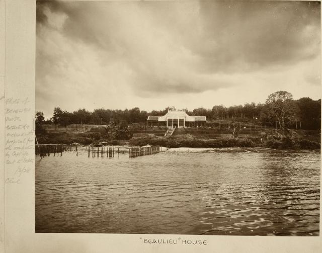


")


