The mention of Tuas, a far flung location in the west of Singapore, conjures up an image of its bleak and rather uninspiring industrial landscape, a patchwork of dull and faceless buildings within which much of Singapore manufacturing output is produced. It would have been a very different Tuas that would have come to mind a little more that a generation ago, a Tuas that for those who express little sentiment for its then untamed shores, would have seemed wild, inaccessible and unproductive; a tangle of mangrove lined tidal inlets and muddy seashores.

The shores of the wild west today.
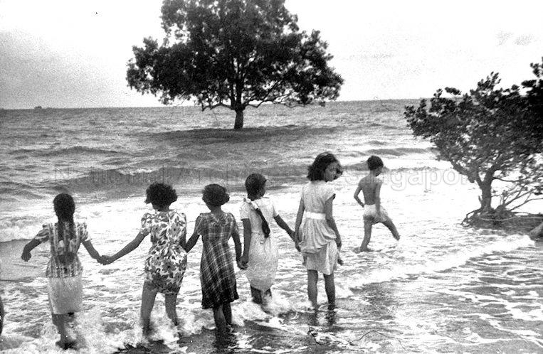
The sea at the far west (National Archives of Singapore).
Wild as it was, it was not without human habitation. Access to the far west certainly was possible, requiring a drive along the long Jurong Road that wound through a rather lonely part of Singapore. The drive would end at the mouth of the Sungei Tuas estuary, the furthest west one could possible head to for a while on a public metalled road. It lay just beyond the road’s 18th milestone and brought with it the promise of seafood at what was the fishing village of Tuas to all who dared to venture.
![Tuas Village, 1970. [This digital copy (c) National Library Board Singapore 2008. The original work (c) Tan Marilyn].](https://thelongnwindingroad.wordpress.com/wp-content/uploads/2015/01/tuas.jpg?w=510&h=395)
Tuas Village, 1970.
[This digital copy (c) National Library Board Singapore 2008. The original work (c) Tan Marilyn].
That reward, would of course only be made possible to those who not only had to endure what seemed an endless journey, but also brave enough; there were parts of the drive that especially on the after dinner journey in the dark, would not have been ones appreciated by the fainthearted. One particular stretch was at the road’s 13th milestone, just before one came to Hong Kah Village on the return journey, had been the source of many a tale of horror. That was where the gravestones of the Bulim cemetery close to the edge of the road, in the glare of the vehicle’s headlamps, would seem to reach out to anyone passing.
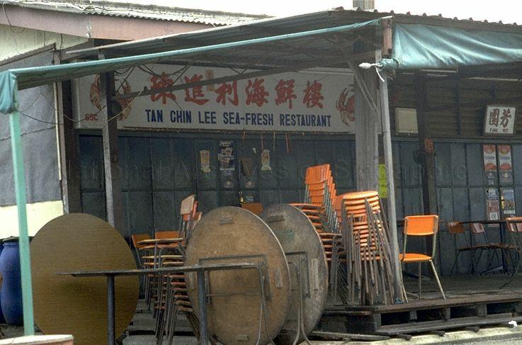
The reward just beyond the 18th milestone of the long and winding Jurong Road – the restaurant is still in existence in a location close to where it originall was (National Archives of Singapore).
It is a different set of horrors that await the visitor on the journey to the Tuas of today; the roads now far from lonely. Much of what we refer to Tuas today lies west of where the village had been, on land that has come out of the sea. This includes the “hockey stick” – a huge southward projection of land to the south part of which will host the future Tuas mega-port. Tuas, at its north-western corner, is also where the Second Link is located, carrying vehicles over to Malaysia, from what had been Tanjong Karang.

A lone mangrove tree within sight of the Second Link.
It is just south of Tanjong Karang where a small reminder of the previously wild west can be found (discounting the vast coastline of the Live Firing Area to its north from which our eyes have been shielded), although it lies out of sight to most of us beyond one of the ugly security fences that kills and deprives of any joys we can still derive from the seashore.

Life where one may not expect it.
The intertidal region that exists, reaches out to the Merwang Beacon. It includes a naturally occurring extension of a much altered shoreline plus perhaps, a small remnant of what could be the original foreshore. It was at this point that the western tip of the island of Singapore in its unaltered state had been at Tanjong Merawang. Around the beacon, and also in the area just north of it where a small cluster of mangroves can be found, we are able to discover that there is still a small celebration of what might have been (see Ria Tan’s post on the visit made on 23 Dec 2014: Return to Tuas Merawang Beacon).

The intertidal zone at Tanjong Merawang looking out towards Merawang Beacon and Pulau Merambong.
A celebration above the sea that the shore also offers, is a perspective of the western end of the Singapore Strait. On a clear day, parts of Singapore, Malaysia and Indonesia can be seen, with the view southwest extending to the Indonesian Karimun Islands. That lies far beyond the Malaysian island of Pulau Merambong in the foreground. It would be interesting to note that the waters around Merambong is home to Malaysia’s largest intertidal seagrass meadow. And, in it, the country’s largest concentration of seahorses is said to be found.

The coastline of the far west of Singapore as seen in a 1927 map.
This is unfortunately, under threat (see: Seagrass meadow in danger, The Star, 24 Mar 2014). Concerns raised on the impact that an ill-conceived and highly controversial luxury development project, Forest City, which will see four huge islands rise out of the waters close to Pulau Merambong, will have, include the threat it may pose to the rich marine life in the waters that surrounds the island. What that will do to what is left of the wild west of Singapore, already decimated by the developments closer to it, time will only tell.


")


Leave a comment