Difficult as it may now be to imagine, but the sea once washed right up to Telok Ayer Street which today has the largest concentration of National Monuments in Singapore. It was along the street that some of the first waves of settlers to the new East India Company factory of Singapore came ashore. Feeling great relief at completing a journey filled with fear and uncertainty, many would have felt the necessity to offer a prayer of gratitude at the shrines and altars set up by those who came before them. Most in the collection of monuments that we see today, house or housed the religious institutions that these places of prayer grew into.
Telok Ayer or Water Bay, before reclamation, c. 1870 (Sachtler & Co). The three towers of the Nagore Dargah, the roofs of the Thian Hock Keng and the 1850s pagodas of the Keng Teck Whay and Chong Wen Ge are visible.
One monument that stands out because of its location at the corner of Boon Tat and Telok Ayer Streets in is the former Nagore Dargah, which has a fascinating tale to tell. It was where immigrants arriving from Nagapattinam – one of the major ports of embarkation in Tamil Nadu offered prayers of thanks to the Sufi saint and protector of seafarers, Shahul Hameed.
The former Nagore Dargah. Its three towers feature niches in which oil lamps could be lit.
The former dargah or shrine is modelled after another in Nagore near Nagapattinam, which was erected around the burial site of the saint. The dargah in Nagore would have been where would be travellers stopped at before making their sea journeys, attracting both Muslims and Hindus. Today, the dargah has become the Nagore Dargah Indian Muslim Heritage Centre, a showcase of Indian Muslim history.
Festivities at the Thian Hock Keng
For many of the Chinese coming ashore, it was to Mazu, that prayers would have been offered to. Also known as Tian Hou — the Queen of Heaven, Mazu has a wide following amongst members of China’s coastal communities, who revere her as the protector of seafarers and fishermen, and by extension, the protector of to those embarking on sea journeys. The old waterfront in way of Telok Ayer boasts of two temples dedicated to Mazu, erected by two of the largest communities of Chinese in Singapore, the Hokkiens and the Teochews.
Thian Hock Keng during the Mazu Festival
The two temples, the Thian Hock Keng and the Wak Hai Cheng Bio or Yueh Hai Ching, are the oldest temples of the respective communities, as well as a point of focus. They are where the traditions of the immigrants are kept alive, and are filled with colour and celebration during festive occasions. One occasion that they both share is of course the birthday of Mazu, which falls on the 23rd day of the the 3rd Chinese lunar month – 1st May this year, 2024. A photograph of the celebration on 1st May at the Thian Hock Keng featuring the Mazu Excursion for Peace, is shown below.
Hop-On Hop Off, which in the frrst weekend, takes us to Chinatown, Kampong Gelam and Little India.
There are many other interesting programmes and installations, two of which are highlighted below. For a full list of programmes for Singapore Heritage Festival 2024, which runs from 1st to 26th May, kindly visit https://www.sgheritagefest.gov.sg/.
HOMEGROUND: We Built This City Also, held in conjunction with the festival is the Homeground installation, HOMEGROUND: We Built This City. This year, it is laid out on the lawn of the National Museum of Singapore and coveS the themes of Nature, Commerce, Community, Residential and Governance. The installation features five displays that detail the evolution of Singapore’s public housing, and a landmark of Singapore’s first UNESCO World Heritage Site, Singapore Botanic Garden s’ bandstand gazebo and also features the whimsical artwork of Cheryl Teo.
Festival Director David Chew with artist Cheryl Teo at HOMEGROUND: We Built This City.
A Rare Opportunityto visit a Living Architectural Conservation Laboratory in a 1880s Shophouse, and get some hands on!
NUS ArClab @ 141 Neil RoadA showcase of jiǎn nián, the traditional decorative technique using ceramics that are fired and deliberately broken Art-noveau decorative tiles, which were imported and were often used to display the status of a house’s occupants – get a chance to learn to clean them! 3-D scanning workshop.
The invasion of futsal cages across the so-called Tanglin Oval is quite a horrifying sight. Surely, the old Tanglin Barracks cricket ground deserves better, having had a place in history as Singapore’s very first dedicated military sporting ground. Set up by the soldiers of the barracks in 1870, the ground represents the commitment of their commander, Major Charles Hamilton Malan, to maintaining the mental, spiritual and physical wellbeing of the troops that he led. Malan commanded the right wing of the then Hong Kong based 75th Regiment of Foot — one of the components of the future Gordon Highlanders.
The 75th Regiment, was the second unit to be quartered at Tanglin Barracks, built to house European infantry soldiers in the early 1860s, but left unoccupied until early 1869. The living quarters back then were a mix of attap thatched timber accommodation blocks laid across the low elevations at Tanglin that up to a decade prior were planted with nutmeg trees. Thick vegetation had taken over in areas that were cleared but not built on. Malan set the troops under his command to work, clearing the “jungle” around the barracks to improve their habitability. The effort provided troops who might have otherwise idled unhappily away in the discomfort of the sweltering tropical heat some purpose.
Carving out a cricket ground — the Oval, as it would come to be known, was next on Malan’s agenda, which as Malan recorded in his memoirs, was no easy task. It not only required the clearing of jungle, but also the levelling of land — all of which was accomplished in a matter of months:
Looking down upon what was then thick jungle I said to my sergeant major: “Sergeant-major, what a capital place this would make for a cricket-ground! I’m an old cricketer; I used to be very fond of cricket. I’ll tell you what it is, we’ll make a cricket-ground. It would be good amusement.”
I looked at my friend’s face. There was a very placid smile upon it; and while he stood strictly at attention, he looked at me, as much as to say, “If you had the whole army here, you would not do it”.
Within six months of that time the jungle was gone, and there, in its place, was a cricket-ground, having a turfed level ninety yards long, forty wide and this level having been made in the slope of a hill!
How often, after it was finished, as I rode or walked up to the hospital to talk to some sick comrade, have I seen the slopes of the barracks covered with men, watching their comrades at play; and how I have lifted up my heart in thanks and praise to God, who gave me the wisdom, energy, and faith in Him to attempt and carry out such an undertaking! The making of this cricket-ground was a work of very great labour. The cutting of the jungle and rooting up the trees was the least part of it.
The former hospital.Malan’s road to the hospital.
Sport has long been a component of military life. Besides the benefits to the physical and emotional wellbeing of the soldiers, sport builds camaraderie and builds bridges between soldiers and their officers.
The cricket field (roots.sg).
Cricket fields and sporting grounds have been an essential feature of British army barracks since the 1840s when General Sir Rowland Hill, Commander in Chief of the British Army, gave orders for a cricket ground be provided in the country’s military barracks and this field in Tanglin Barracks represents the first attempt to export this to Singapore. Up to the point that it got “caged”, the field remained much as it was for over a 150 years. The addition of the futsal cages, laid on a raised bed of concrete, has quite sadly put an end to the field and the legacy (even if one can argue that the futsal cages continues its use as a sporting ground) that Malan left behind. It has also destroyed the wonderful view of the slope that Malan mentions, as well as adding the unsightly clutter of cages.
The former Tanglin Oval, before it was desecrated. The “slopes of the barracks covered with men, watching their comrades at play” that Malan described seeing as he made his way to the hospital (now Loewen by Dempsey Hill) can quite clearly be visualised.
The Tanglin Oval, late 1960s. John C Young Collection, courtesy of National Archives of Singapore
The ugly mess that Malan’s field has become.Work started at the end of last year.De-fielding Malan’s cricket field :(.
As well as having the power to evoke a deep sense of longing in us for places we can no longer see, old photographs can be windows into the past, and provide us with clues to life beyond what the rose-tinted lenses we often have on, have us see.
This 1941 photograph, is a perfect example. Captured in colour — a rarity for photographs from those days, it was one of a large number taken by Harrison Forman. Forman was one of two American photographers, the other being Carl Mydans, who documented a Singapore making preparations for a war that no one thought would come to its shores.
McCallum Street, 1941, Harrison Forman Collection
The photograph shows an incarnation of McCallum Street that we may have forgotten about, as a street that looked quite typical of much of built-up Singapore, lined with a most common of urban constructs, shophouses, with poles of laundry hung out to dry. The shophouse façades are also quite typical, and have inscriptions in Chinese characters that told of the aspirations of the houses’ earlier occupants. A rickshaw dates the photograph to before they were taken off the streets in 1947. Interestingly the shophouses are raised, which could indicate that the possibility of the street being flooded was considered in their construction.
Another interesting aspect of the photograph, is the absence of any form of street lighting except for a single gas lamp post. Gas lamps provided much of the public illumination back in the day, and the single lamp would certainly not have brightened the street to the levels that we have come to expect today. The municipality’s first gas lamps were lit came on 24 May 1864, the birthday of Queen Victoria, and replaced the much less effective oil lamps that were first introduced on 1 April 1824. For the purpose, the Singapore Gas Company was established in the 1860s to produce methane from coal. The gas company was transferred to the municipality in November 1901.
By the time that this photograph was taken, electricity also powered a selection of street lamps. Electrical lighting on a large scale was first seen in 1897 on the premises of the Tanjong Pagar Dock Company. Electricity however, was only made available to the municipality in 1905 through an arrangement with the Singapore Tramways Company to supply of excess power from its plant in MacKenzie Road. Electric street lighting was introduced in 1906 to light up Raffles Place, Boat Quay and a section of North Bridge Road. It would however only be in the mid-1950s that a complete switch was made to electric street lighting.
There would also have been other items connected with gas lighting and gas supply that would have been visible. Some appear in other photographs from the era. The huge gas holder at Kampong Bugis, part of the Municipality’s Kallang Gasworks, was on item that was quite a landmark. It was after the gasworks that the name of the area in the Hokkien vernacular, “Huay Sia” (火城) or “Fire City”, came about.
Another large gas holder from the pre-war era that was also a visible landmark was located off Maxwell Road. Installed in 1913 and reconstructed after the war, the Municipal (later City Council) Gas Holder stood on a site just across what became Kadayanallur Street from Maxwell Road Market (now Maxwell Food Centre) — right where URA Centre stands today.
The Gas Holder at Maxwell Road.
The use of gas lamps also required an team of lamplighters to be employed. The task of the lamplighter was to light the lamps up at 6 pm and blow them off at midnight. The installation of time switches in the 1940s reduced the need for these lamplighters, although many remained in employment to clean and maintain the lamps and as back ups should the automatic timers failed. The task was by no means easy or safe, lamplighters could be seen carrying their ladders on bicycles and propping them against the arms that projected horizontally from the gas lamp posts. There were a number of fatal accidents involving falls or due to lamplighters being struck by vehicles in the course of performing their duties.
The view from a reimagined sea … to an earthly abode of the goddess of the sea.
It may be difficult to imagine it now, but there was a time when the sea washed right up to Telok Ayer Street.
Those were times when the street was a landing point. Many who came ashore here would have left home and family to embark on a journey that was filled as much with hope and promise, as it would have been with apprehension and uncertainty.
Coming ashore having survived a passage across tempestuous seas, the newly arrived had much to be grateful for. Shrines placed so homage could be paid to the heavenly beings whose powers of protection had been called upon were a necessary first stop. As the communities grew, in both numbers and wealth, these shrines of gratitude were made more elaborate, and serving as focal points for the communities that erected them.
One such shrine turned elaborate place of worship was the Thian Hock Keng, a focal point for the Hokkien community and the subject of the photograph. Dedicated to the protector of seafarers, Mazu, the temple is a joy to photograph in its various moods.
More on the temple, its activities, and Telok Ayer Street can be found in these posts:
I just uncovered this gem, from an interview that I conducted in 2014 with three sisters, Neng Atini Roslan, Danilah Roslan and Siti Dahlia Roslan.
The Girls of Jalan Saksama, as I called the sisters, had some wonderful stories to share of their experiences in Kangkar Fishing Village and in Jalan Saksama in Changi — two places that we can now only imagine.
With the Girls of Jalan Saksama, an elder sister, and a cousin.
Memories of Kangkar
Our father was a health inspector with the health department. Before Dahlia was born, we lived in a bungalow that belonged to the government, in Kangkar, near Punggol.
Kangkar was a fishing village. There was a fish auction market there, next to our house, and beyond that, a jetty. A police station stood at the end of the road.
There was also a mama (a commonly used Tamil word in reference to an elder or an uncle) prata shop right next to our house. The people who worked there came from India and wore a short sarong that was often pulled up.
The men had left their families back in India. They missed their children and every time they saw us, they would try to hug and kiss us. We never liked it and avoided going into the shop, even when we had to ask to borrow their matches.
The catch was brought in to the fish market very early every morning. Lots of boats came in. Although it was hard to tell from their sun-darkened skins, the fishermen were mainly Chinese. They came from Indonesia and spoke what sounded like Hokkien, or possibly Teochew.
We could see the auction from the balcony of our house, hearing shouts of “sa-chap, sa-chap; see-chap, see-chap; gor-chap, gor-chap” – “thirty (dollars), thirty; forty, forty; fifty, fifty” as the auction progressed. We once saw a huge turtle being sold. It had been turned upside down.
A towkay from the fish market, Mr Png, was very nice to us. He often allowed us to pick the best live fish for free. We could also take dead fish to feed the cat.
We were the only Malays in the village. During a visit there by the then Prime Minister Mr. Lee Kuan Yew, as the only Malay man there, my father was invited to sit next to him.
It was the Chinese neighbours, Mr Png in particular, who helped to protect us during the racial riots. There was a curfew during one outbreak. Our father couldn’t come home and called Mr Png, who came over with the news. He advised us to stay indoors, keep our doors locked and to expect a lot of noise. He also said we would be safe upstairs and gave us some fish to eat.
The riots spread to the village and it was frightening. We could hear the commotion outside, but our mother kept us well hidden on the upper floor of our house. The long stairway of 30 steps that led up could be raised and closed. We kept our heads down so no one would see us.
Mr Png had a son named Tai Seng, whom he had offered to my parents for adoption since there were only girls in our family. At the time, our mother was expecting Danilah and so declined the offer. She thought it would be too taxing to take care of two infants.
With Mr Png and the other Chinese villagers, we communicated in Malay. Everyone spoke some form of Malay then.
The Chinese wayang came to the village during the Chinese festivals. We remember a festival during which we could see the loh-tang, mediums in a trance. They seemed to go crazy and would sometimes chase the children. During that festival, ash would be thrown into the river.
Changi: “The Best Years of Our Lives”
In 1967, we moved from Kangkar to Jalan Saksama near Changi, where our parents bought two acres of land close to Kampong Darat Nanas, behind Changi Prison. The beach was close by, about half an hour’s walk away.
The house that we lived in had already been built when we acquired the land. My father refurbished it and whenever he had money, more rooms would be added. We got our drinking water from a standpipe. Water for other uses such as washing, came from a well.
Unusual as it may have been for Muslims, we had four dogs. They were needed for security. We also kept chickens, geese, turkeys, guinea pigs and even mongoose.
My father planted many trees: forty coconut palms, twenty rambutan, twenty mango and four durian trees. The durian trees only started bearing fruit as we were about to vacate the place. The rambutans were of both the red and yellow varieties. There were also jackfruit, papaya, soursop, custard apple and jambu trees.
We loved climbing the trees. Often, so as to be undisturbed by our dogs and chickens, we would climb a tree to eat nasi lemak, which would be wrapped in a banana leaf. We each also had a favourite tree, from which we would sometimes hang upside down.
There was a Chinese vegetable farm near our house. The farmer also kept pigs. This was perhaps for their manure, which was used as fertilizer. For just five cents the farmer allowed us to pick almost anything we needed from the vegetable plots and often we would take home two to three kilogrammes of vegetables.
From the farm, we also got our supply of fresh eggs, to supplement the eggs our own chickens had laid.
On the left side of our house, there was a sugarcane plantation and also a chiku and rambutan plantation. We would sometimes help ourselves to the fruit, filling baskets we carried with us. Whenever a car passed, we would hide or pretend to be picking grass for the chicken coop.
Our father was the sole breadwinner and whatever he earned went into supporting the family. We had little in terms of luxury and had ice cream only once a month. We bought this at the provision shop that we visited once a week for our grocery shopping.
We purchased groceries on credit. The credit the shopkeeper extended to us was recorded in a little booklet in which we were identified as orang kaya or rich people. It always seemed ironic to us as we owed the shopkeeper money for every item that we purchased. The shopkeeper somehow trusted us. He never failed to deliver the goods on the list our mother prepared, no matter how much we owed him.
The shop was located halfway along the road to the prison, which was in Upper Changi Road. We always had the dog Blackie with us. It was probably because of the dog that the other Malay folk in the village were wary of us. As a result we did not mix with the other Malay children in the village.
There were several other shops at Kampong Darat Nanas. Besides the Malay shop that we got our groceries from, there was also an Indian shop and a Chinese provision shop that was closer to the prison.
For 5 cents we got our supply of ice-balls from the Chinese shop. The ah-pek (a Hokkien word that refers to an elderly man) at the shop never seemed to wash his hands when he made the ice-balls. We never washed ours either and devoured the flavoured ice as fast as we could.
There was a big tree in front of the prison. The top part of the tree seemed to be dead, but the bottom was somehow alive. We called it the “haunted tree”. Everyone from the village seemed to keep well away from it with the exception of the Chinese folk because a Taoist shrine was maintained under the tree.
We were not supposed to go to the beach on our own, but we went whenever we could. This would usually be during the weekends or during the school break. What drew us to the beach was that we could play in the sea. With Blackie always by our side, we headed there on the dirt road that led to the coast.
There was a spring along the way, very close to the sea (this would have been at Ayer Gemuroh). Water gushed out from it and came out of a slope by the side of a road. It was where we could stop to quench our thirst. We never had to carry water with us.
We gained access to the beach from the side of a mosque located by the sea. There seemed to be no access from other areas along the beach because many houses and bungalows had been built there.
Our home in Changi provided us with the best years of our lives. Sadly, we had to leave it behind after living there for about 10 years because the government wanted to acquire the land to build Changi Airport. We were given six months to vacate our home.
The Pain of Moving
We decided to move out early although many of our neighbours stayed on for as long as they could. We did not want to live there without water and electricity, which had already been cut-off.
Since the flat we had applied for in Haig Road wasn’t ready yet, we were provided with temporary housing for three months, so we moved into a very cramped two-bedroom flat in Changi Village. It was rather stressful for us. There was nowhere to run around and we cried all the time.
Our father also had to give the dogs away, to a friend of his who lived on a property with land in Punggol. The dog that we were close to, Blackie, often attempted to look for us.
Once, when we were going visiting in a car, we saw a dog puffing and panting, running along the road. It was Blackie. He had run away from his new master and had somehow found us.
Blackie also looked for Danilah at Bedok Primary School where she went to school. On one occasion she had seen a dog from the bus she had boarded on her way home from school. Danilah recognised Blackie and as soon as she reached her home in Changi Village, she threw her books and her violin down, then took a bus back. Blackie was still waiting for her and when she called and approached, he immediately jumped up on Danilah, who started crying.
At Changi Village, we walked to the beach every morning. We also went fishing. There were plenty of fish to be caught, including ikan tamban (sardine) and ikan selar (yellowtail scad), which we caught without using bait. We would spend hours fishing.
Life was very different when we moved to Haig Road. A lot of adjustment was needed and it took us a long time to adapt.
These days we are spread far and wide, Danilah has moved to the U.S. and Dahlia now resides in Bahrain. We try to come back every Hari Raya and that is when we can reminisce about our days by the sea. We deeply miss the sea and everything about the place we had by the sea. We miss the trees, the dogs, climbing trees, running around, and most of all, the freedom that living there had allowed us.
A page from the Street Directory showing Jalan Saksama in relation to Tanah Merah Besar Road and Changi Prison. A large part of the area is now where Changi Airport is.
Life in Singapore can be maddening at times. One of the world’s most congested territories, the city-state has a population density that translates into there being less than 124 square metres for every person, a space no larger than a HDB five room flat! This becomes quite evident at rush hour, at lunch time, or before and after mass participation events when the use of the Chinese expression, 人山人海 (which can be translated to “a mountain of people, a sea of people”), would well describe the city’s pavements, underpasses, MRT stations, shopping malls, trains, and buses.
Thankfully, one thing that Singapore does also have are an abundance of spaces to find an escape in. This is the case even in the urban centre, where little nooks and crannies, quiet spaces to cool off, and even roof tops with a view can offer respite. There are also fabulous parks and gardens. Further afield, parts of the now well trampled former Rail Corridor can still provide that sense of isolation that it used to when the trains were running, as do a collection of nature parks and sections of Singapore’s nature reserves to which access is provided.
I am often drawn to the magical quality that these spaces exude. It could be provided by the calls of nature, the smallness that one feels amongst the trees, the play of light and shadow or the pure joy of seeing sunlight streaming through the trees.
Ten Magical Spaces
[1]
Under the Giant Rain Tree | Fort Canning Park
Rain trees, instantly recognisable due to the umbrella like shape of their crowns, offer shade from the intense tropical sun. Their crowns can spread up to a massive 30 metres across. Native to tropical America, they were introduced to Singapore in the 1870s and have been among the most commonly planted roadside trees.
[2]
The Tunnel of Trees | Marang Trail
The Marang trail starts at the foot of Mount Faber, taking a path through an area of secondary tropical forest, and ascends 70 metres to the top of Mount Faber. A tunnel of trees — formed by the lush canopy at the start of the trail can be a sight to behold.
[3]
Walking amongst Giants | Former Rail Corridor at Kranji
Albizias, are another tree species that is not native to Singapore. Fast growing with thin trunks, they propagate rapidly across disused plots of land and pose a danger to walkers and hikers due to their frailty. They however grow to great heights and are thus used by birds as nesting sites. The rail corridor used to be lined with them, while some have been removed due to safety concerns, a section of the former corridor that will soon see development at Kranji is still lined with them, giving the impression of walking among giants.
[4]
Into the Light | Thomson Nature Park
Thomson Nature Park was established in a narrow wedge of land sandwiched between Upper Thomson Road and Old Upper Thomson Road. It was once home to a settlement of immigrants from Hainan, some of whom cultivated rambutans. The villages were one of the last to be supplied with electricity. Lorong Pelita, one of the roads in the area, possibly reflects this fact as pelita is Malay for oil lamp. The park is especially beautiful in the early part of the day, especially on a misty morning with sunlight filtering through the trees.
[5]
A Feeling of Being Watched from Above | Lower Peirce Trail
Colugos or flying lemurs are amongst the strange creatures that inhabit the forests of Singapore. They can be seen clinging on to trunks of trees and their ability to glide gives them a relatively long and wide reach. They have been spotted around the Central Catchment Reserve, Bukit Timah Reserve, Rifle Range Nature Park and above the boardwalk along the Lower Peirce Trail. Nocturnal creatures, they possess large eyes and whilst on the boardwalk you may get this feeling of being watched from above.
Besides that feeling of being watched, parts of the trail carry you past a stream by which you could be serenaded by a chorus that has been described as sounding like dripping water. A closer inspection of some of the low lying vegetation may reveal the source of the chorus — tiny copper-cheeked tree frogs no longer than the length of your last finger.
[6]
Lake District | Central Catchment Reservoirs
The development of Singapore’s first impounding reservoirs, MacRitchie, Lower Peirce (pictured above), and Upper Seletar — and also Upper Peirce later, created a series of water bodies close to the fringes of the Central Catchment Reserve. Parks and look out points offer beautiful vistas of what can be thought of as Singapore’s lake district.
[7]
Changi Rocks! | Changi Point Coastal Walk
A place that has been close to my heart for much of my life, Changi was where I took many a holiday at as a child. Changi Point, west of Changi Village, is still very much how it was back when I first visited the area in the early 1970s. Mixed with old buildings of an almost intact 1929 to 1935 built Kitchener Barracks is still intact, as are many additions put in by the RAF when it took over after WW2. Some of these structures became additional holiday bungalows in the 1970s, others were used in various ways including as Commando Camp. Steeped in history and home to POWs in the early part of the occupation, many fascinating tales of the past are found in them. The biggest treat is the area’s unaltered natural beauty. A walk around the Changi Point Coastal Walk, is always a joy, taking me by a sea I knew well from my many childhood dips in it. The boardwalk also takes a route past rock formations that are stand out even in early 20th century postcards, natural elevations, and a set of cliffs that one might not expect to see in the manmade Singapore of today.
[8]
The Pier | Lim Chu Kang Nature Park
Cashin House in Lim Chu Kang Nature Park is always a joy to visit. The “house” — the sensitively rebuilt sea pavilion structure that the Cashins referred to as “The Pier” offers a perspective of living by the sea. Built as a pier for the export of rubber from Alexander Cashin’s Sungei Buloh Estate in 1906, rooms were added to the end to serve as quarters and later a holiday home. One of the first points of landing during the Japanese invasion of Singapore in February 1942, the site by the house was where an Australian battalion put up a heroic fight, holding position against the odds before eventually withdrawing.
The Pier would be enlarged and serve as the home of Alexander’s son Howard from the 1960s and vacated following Howard’s death in 2009. With the marine environment wreaking havoc on the structure of The Pier, a decision was taken to have it rebuilt for it to be useful in the longer term. Being in the house, puts you close to nature, and well within sight of the coastal mangroves that are currently being restored. At low tides, a crocodile or two may be spotted basking in the sun on the mudflats. Visiting the house once, stokes the desire to come back for more. While the house is not opened to the public, visiting it is possible through NParks organised tours and programmes to it.
[9]
The Gateway to the Past | Kampong Tengah, Sembawang
The presence of mysterious gate in Sembawang, one that seemingly leads nowhere, has made the area it is in the subject of much speculation. Imaginative tales are told of the gate. If some of these are to be believed, the gate, may be a portal to another dimension, or one that through which energy of a supernatural nature flows.
There is a less sinister explanation for the presence of the gate, having been the main gate of the seaside property of Chua Boon Peng of Cycle and Carriage fame. It was one of a small collection of seaside homes developed by Mr Chua, another of which was the home of architect and artist James Westwater Ferrie whose artistic endeavours included watercolours of the area’s seascapes.
The houses are long gone, as have the villages that once brought life to its surroundings. The rather forlorn gate is best visited in the mornings an hour or so after sunrise, when the place often takes on a magical quality given by the light of the rising sun filtering through the trees.
[10]
A Bar at which You Could Meet a Mermaid | Coastal Sembawang
Sandbars were and still are a common sight along many parts of coastal and even offshore Singapore. They often, especially the ones offshore, make for interesting photographs. One large sandbar can often be seen at the lowest of tides just east of Sembawang Park in the area close to Kampong Wak Hassan and the former Kampong Tengah. The sandbar provides opportunities for stunning photographs, especially during sunrise, as well as a great view of the ships being repaired at the former Sembawang Shipyard (now Seatrium Admiralty Yard), which will soon be shutting its doors. The yard, developed out of the former naval dockyard, together with the port facility operating in the former stores basin, is the last working remnant of the massive British naval base set up in the 1930s to defend British interests in the Far East.
Senoko Fishery Port, which has its roots in the Teochew run fish businesses of the old Kangkar fishing village at the end of Upper Serangoon Road, has less than two weeks before it shuts for good. Once home to the remnants of Singapore’s fishing fleet, which moved from Kangkar — when it boasted of 90 boats — to Punggol in 1984, before ending up in Senoko in 1997, the so-called port operates in more recent times as a fish wholesale market.
A parting glance at Senoko Fishery Port (1997 to 2024)
Home to a tightly-knit community of 25 traders, the area of the port is intended for redevelopment — word has it that the site will host an expansion of the Micron Semiconductor plant. This will see the displaced fish traders move to the much larger Jurong Fishery Port at which all such businesses will be consolidated.
While the move is welcomed by some, who look towards the larger customer base in Jurong, many others are saddened by their last link to Kangkar’s once famous fishing port, the small but loyal customer base in the north, and the community and the air of friendly competition in which the businesses operated.
For their clients, many of whom are northern base, it also means the time and expense of having to traverse across a much larger distance to obtain supplies.
The fishery port will operate for one last time on 17 March 2024, after which most of the businesses there will move to their new western home.
Lian Yak — which has been in business since 1955 and is the oldest fish trader in Senoko. The company, which operated first in Kangkar, also ran a fleet of fishing boats.
Street names in Singapore often hold clues to the past. Names such as “Telok Ayer Street” and “Beach Road” for example, provide an indication of where the city’s original shoreline might have been. And just as there was originally a “telok” or bay along which Telok Ayer Street ran, there was also a beach by Beach Road.
Among the questions that come to mind are: what did the beach look like, and how far did the beach stretch? Well, we do know for a start that the beach was pleasant enough for Raffles to have the stretch along the beach reserved for the dwellings of the new settlement’s elite residents as part of the European section of town (see: Middle Road and the (un)European Town). Known as the “street of twenty houses” in the vernacular, a row of twenty large compound houses did actually take up the prime stretch of Beach Road fronting the beach.
Where the beach along Beach Road would have been — from a 1839 Map of the Town and Environs of Singapore.
To address the first question as to what did the beach look like, we do fortunately have more than just textual descriptions of it. A visual representation of the beach can be found in a sketch from 1847 that was made by Government Surveyor John Turnbull Thomson. Titled “View from Campong Glam”, the sketch shows a sandy beach with identifiable buildings such as The Arts House (ex-Parliament House and then Public Offices / Courthouse) and the former Raffles Institution.
J T Thomson’s 1847 sketch depicting the beach along Beach Road.
As for the extent of the beach, archeological evidence does show that the beach extended from the Singapore River (as is also seen in J T Thomson’s 1847 sketch) to Kampong Gelam. Excavations carried out in 2003 by Professor John Miksic and his team in the National University of Singapore have in fact revealed the existence of a layer of pure white sand under the Padang close to St Andrews Road dating back to the 14th century — the period when Sri Tri Buana or Sang Nila Utama established a port city in Singapore. Further excavations have confirmed that this white sandy beach stretched at least to the area fronting Istana Kampong Glam (Malay Heritage Centre). What is particularly interesting is that the white sandy beach, based on Prof. Miksic’s reckoning, may be the beach that drew Sri Tri Buana to the island, which is described in the Malay Annals as one with “sand so white that it looked like a sheet of cloth”!
Beach Road, late 1800s (G R Lambert)
Among the houses for the European elite fronting the beach was house number one at which Raffles Hotel would be established in 1887. By this time, most of the compound houses along the beach had disappeared and those that remained, had taken on a shabby appearance with the well-to-do having made the move to the more comfortable interior of the island. The area had in fact already morphed into Sio Po, the Chinese lesser town with the Hainanese community having established a temple dedicated to the protector of the seas, Mazu, at Malabar Street in 1857.
No 1 Beach Road at which Raffles Hotel was established in 1887.
It was soon after the establishment of the hotel, that it began to lose sight of the beach across Beach Road with reclamation works for what would later be known as the “Raffles Reclamation” beginning off the Esplanade — amid a blaze of rumours that sacrificial human heads were needed for work to proceed smoothly (yes, such rumours existed even then!). This would lead to an expanded Padang of the size we know today and the addition of land on the Beach Road side. By the early 1900s, the reclamation ground — which was used to dump mud dredged from the Singapore River — had become substantial enough to permit the ground to be used for polo and other sports. The old volunteer drill hall was also moved to it in early 1908 from its original site at Fort Fullerton.
The newer Drill Hall at Beach Road, which replaced the older drill hall that was moved over in 1908 from Fort Fullerton.
The reclamation site would also be where Singapore’s first permanent cinema halls were erected. Cinema first came to Singapore in 1897, just two years after the Lumière brothers exhibited the Cinématographe in Paris. Exhibitions were held either in halls and tents before the first permanent structures appeared on the Raffles Reclamation site in the 1900s.
Permanent cinematograph halls were among the first structures erected on the reclamation at Beach Road.
Further reclamation would take place through the 1930s, by which time structures such as Beach Road Camp and a newer Beach Road Police Station started to populate the reclamation site. The coastline would be altered further with the construction of Nicoll Highway in the mid-1950s and the development of what would eventually become Marina Bay, bringing us to where we are today.
1936 view of the reclamation.
Post-World War Two extent of the Raffles Reclamation.
It was a hundred years ago on this very day, the 17th of September 1923, that the Causeway first came into use, when a cargo train made the crossing on tracks laid temporarily on the completed half of rubble mound which had been intended for its roadway.
A train crossing the partially completed Causeway in 1923.
Linking the island state of Singapore with Malaysia across the Straits of Johor, the one-kilometre long link is a hundred years later, one of the busiest land border crossings in the world. Hundreds of thousands cross daily with most using motor vehicles. The sheer volume of vehicles using the link does mean that traffic congestion on the Causeway and the roads leading up to it are quite a frequent occurrence, so much so that the Causeway has become synonymous with traffic jams.
A passenger train going across the Causeway in 2023.
It was in fact to solve the problems caused by heavy cross-strait traffic, albeit of a different kind, that the Causeway was built. It was also for the same reasons that Causeway was first made available for use by freight trains, which was a matter of urgency. The cross-strait movement of goods railway carriages had been made possible December 1909 when a wagon ferry built by the Tanjong Pagar Dock Board was put into operation, with a second added soon after. With the Johore State Railway (JSR) having been completed earlier in that same year, the wagon ferries permitted whole railway freight carriages to be moved between Singapore and the parts of the Malay Peninsula that the JSR and other lines that it was connected with.
Vie of the Causeway under construction with the railway wagon ferry jetty at Woodlands also in view (Tessa Mitchell Collection, National Archives of Singapore).
Fed by the growing demand for rubber in the 1910s, the volume of rail carriages carried across the strait by wagon ferry grew by leaps and bounds. In 1911, some 11,500 carriages were being carried across the strait. By 1917, cross-strait cargo wagon traffic grew five-fold with some 54,000 carriages were moved by the ferries. Carrying six freight carriages at any one time, the ferries were made to operate continuously day and night to cope with the demand, which put a huge strain on them. On the recommendation of Mr P A Anthony, the General Manager of the Federated Malay States Railway or FMSR (which had absorbed the JSR and the Singapore Government Railway by that time), a decision was taken to construct a link.
The Causeway under construction, 1923 (National Archives UK, no known copyright restrictions).
While a bridge across the strait might have been a desirable outcome, the relative ease with which a rubble causeway could be constructed and maintained together with the associated savings in cost, pushed the decision towards a causeway. Designed by consulting engineers Coode, Fitzmaurice, Wlison and Mitchell and constructed by Topham, Jones and Railton, work on the Causeway commenced in April 1920. The large amounts of granite that was required, came from either quarries in Bukit Timah, or the island of Pulau Ubin. Granite from Pulau Ubin could quite conveniently be transported by hopper barge and dumped directly on site and it was from the island that the bulk of the material came from.
A typical cross section through the rubble causeway. Most of the granite that was used came from the island of Pulau Ubin.
With granite coming by barge from Pulau Ubin, the Causeway could only be finished west to east once the gap was closed, meaning that the roadway side of its width was completed before its railway side. It was for this reason that temporary tracks were laid to permit the freight trains to use the link first. Two weeks after the link for cargo trains was established, passenger trains followed, with the first passenger train, an overnight mail train from Kuala Lumpur being the first to cross on 1st October 1923. The Causeway would only open to road traffic more than half a year later, following its completion and rescheduled official opening on the 28th of June 1924, with the very first car to cross carrying the Governor of the Straits Settlements Sir Laurence Guillemard, and Sultan Ibrahim of Johore.
The Causeway Lock under construction (National Archives UK, no known copyright restrictions).
Completed at a cost of 6.5 million Straits Dollars, three quarters of which was borne by the FMSR, some 1.5 million cubic yards (1.15 million cubic metres) of granite was used to build the 60 feet wide and 3465 feet long link. A feature of the newly completed Causeway which is no longer seen was a 50′ wide and with a 32′ clear span rolling lift bridge, and a 170 feet long lock with a width of 32 feet at the gates. Running across the Johore end of the Causeway, the lock permitted the east-west passage of small vessels such as fishing craft with the bridge fitted to cross the gap. The lock and bridge were deliberately destroyed by British-led forces as they withdrew from Malaya into Singapore on 31 January 1942 (with a 70′ gap was also blown in the Causeway). Along with the lock, ten 5 feet diameter culverts were also built into the Causeway, which allowed water to flow across the width of the link and prevented the accumulation of rubbish. The culverts, several of which were destroyed during the British January 1942 withdrawal, are now mostly out of action.
The Causeway with a gap blown into in on 31 January 1942.
The “Causeway jam” does seem to have been a perennial problem. Just two years after it opened to road traffic, the first traffic jams were reported. The jams were due to the digging up of sections of the roadway so that a pipeline to carry water from the intended Gunong Pulai Reservoir to Singapore could be laid. The post-Second World War era would see much greater traffic snarls. In 1948, increased security checks (due to the Malayan Emergency), saw to traffic hold ups. The traffic situation on the Causeway seemed to worsen through the next decade. In 1950, crowds heading to the Johore Grand Prix were reported to have caused a 3-mile (5 kilometre) traffic jam, which resulted in the start of the races being delayed. A “monster traffic jam” on 17 September 1955 — the 32nd anniversary of the Causeway’s first use following Sultan Ibrahim’s Diamond Jubilee celebrations resulted in 10,000 people being stranded in Johor Bahru. Festive traffic also caused traffic hold-ups, with “chaotic scenes” on the Causeway being reported during the Chinese New Year in 1959. As a result of increasing demands, the Causeway has been widened on several occasions starting with a 1.5 metre increase in its width in 1964.
The Causeway in the 1970s.
The appearance of the new Customs Checkpoint at the JB end in 1957 — just in time for Malaya’s independence from Britain, would be a sign of things to come. With Singapore and Malaya being pulled in opposite directions following a brief merger that ended with Singapore’s independence in 1965, immigration controls became necessary. It was however only in 1967 that full immigration controls were implemented — on 1st July 1967 by Singapore and on 1st September 1967 by Malaysia.
The JB Customs Checkpoint in 1957.
In 1998, a second link was opened across the strait. While this might have gone some way to ease the load on the Causeway, the sheer growth in cross-strait traffic now sees regular jams taking place on both crossings. In March 2020, the Causeway (and the Second Link) did however fall silent. This was a result of the border closures due to the global pandemic. The links were only reopened on 1 April 2022.
The Causeway fell silent due to the Covid pandemic.
Now one hundred years later, a third crossing is being established in the form of the Rapid Transit Link or RTS, a light rail line that will be carried over a 25 metre high bridge across the strait between Singapore’s Woodlands North MRT Station and Bukit Chagar in Johor Bahru. When completed in 2026, the RTS will replace the conventional railway (now reduced to the rail shuttle service between JB and Singapore run by Keretapi Tanah Melayu). And with that, Singapore’s twelve-decade long association with the conventional railway, and a hundred year conventional railway link with the Malay Peninsula — the Causeway’s original raison d’être, will be brought to a close.
The RTS being built just a stone’s throw from the Causeway, a century after the Causeway was being built. The RTS will replace the KTM run shuttle service between Singapore and JB.
The view from what is Esplanade Park today, 8 decades and more than a world apart. What the photos have visibly in common is the Fullerton Building, then the General Post Office, and today the Fullerton Hotel.
The older photo shows the desolate scene on the morning of 16 February 1942, the morning after Singapore’s fall to Japan. Taken on what seems to be part of the unfinished reclamation ground in way of the Esplanade (on which Queen Elizabeth Walk would eventually be built), the scene in one that is in stark contrast to the view of the same area today, taken from a somewhat different position but showing the same general view of what is today the CBD. The modern scene is of course one that many across the world would be familiar with, being one that receives a fair amount of coverage around the world during Singapore’s F1 night race weekends each year and one that is a great showcase of the Singapore success story.
The story behind the 1942 photo, or rather the photographer behind the first photo is perhaps not talked about enough in Singapore. It was one captured by an Australian POW by the name of George Aspinall, who was behind a series of very bravely taken photographs that documented among other things, the cruelty of a part of Aspinall’s time as a POW. During part of his captivity, Aspinall was able to conceal a camera that an uncle had given him prior to his departure for Singapore. Remarkably, Aspinall also managed to conceal a stash of x-ray negatives and processing chemicals that he had discovered, taking them with him to captured the horrors that POWs were subjected to working along the so-called Death Railway. With the chemicals, he was able to process the x-ray negatives that he had used in his camera. While he may have disposed of his camera before his return from the death railway for fear of it being discovered, Aspinall managed to hold on to the precious processed negatives, some of which survived being buried in a latrine bore hole in Changi prison.
Among the photographs that Aspinall captured as a POW in Singapore were those that were taken during the Selarang Barracks (Parade Square) Incident, during which more than 15,000 POWs were squeezed into the the Selarang Barracks parade square to persuade the men to sign a non-escape statement. More on George Aspinall and his photographs can be found at https://www.awm.gov.au/collection/C340159.
I had the opportunity to have a first look at Bird Paradise, Mandai Wildlife Reserve’s latest attraction.
Set on a 17 ha site close to the Mandai Road end of Mandai Lake Road, the successor to Jurong Bird Park will — at least at first glance — have what it takes to build an identity of its own. While it may not have a single iconic feature, which its predecessor had in its Waterfall Aviary, the new park does have a host of features that will allow visitors a more immersive experience. The highlight of Bird Paradise for me is its eight large walk-through aviaries — twice what Jurong had, each of which brings a varied experience.
Park information
Bird Paradise opens on 8 May 2023 and tickets (single-park admission), which go on sale from 24 April 2023, will be priced at $38 for adults, $23 for children (ages 3 to 12 years old) and $20 for senior citizens, from 8 May to 26 May 2023. From 27 May 2023, Single-park admission is at the full price of $48 for adults, $33 for children (ages 3 to 12 years old) and $20 for senior citizens.
All admission tickets must be purchased online at https://www.mandai.com/en/bird-paradise.html, prior to visiting Bird Paradise. An advance time slot booking is required. All ticket holders are required to make a booking before visiting Bird Paradise.
Participation in all feeding programmes must also be pre-booked on the ticketing website. A token fee of $8 per session applies for each participant.
Bird Paradise will be open daily from 9am to 6pm. Last admission into the park is at 5pm.
Prepare to be wowed even before you enter — the cascading waterfall, which you will encounter at the drop-off to Bird Paradise / Mandai West Node.
Under the winged canopy at the Bird Paradise entrance.
The back end of the Entrance Plaza
The cascading waterfall greets visitors at the Entrance Plaza, around which orchids recall the former Mandai Orchid Gardens which used to occupy the site.
Ocean Network Express Penguin Cove Penguins being moved.
At 3,000 square metres, Ocean Network Express Penguin Cove is a multi-level, state-of-the-art indoor habitat that showcases the fascinating behaviours of penguins. Its two large acrylic tanks each hold one of the biggest water volumes in the world to house penguins. Consisting of two storeys, the cold saltwater habitat allows guests to view penguins diving into the depths and emerging onto a Sub-Antarctic beach to waddle around under a domed sky surrounded by a projection of the Southern lights, the Aurora Australis. Lighting in the tank is designed to mimic the day and night of the Sub-Antarctic islands and complement the penguins’ breeding cycles.
4 species of penguins, which are Gentoo Penguin, King Penguin, Humboldt Penguin, Northern Rockhopper.
Get a rare glimpse underneath the swimming penguins from an acrylic dome on the first storey. Head to the mezzanine level for a multimedia projection highlighting the four seasons in the life of a King Penguin’s colony and impact of climate change on penguins in the wild.
Keeper Talk at 1.30pm daily. Learn about penguin behaviour and the personalities of individual penguins from their keepers.
F&B: Ocean Network Express Penguin Cove also features a dining experience immersed in an underwater environment with the aquatic birds at Penguin Cove Restaurant. Penguin Cove Café and Shop occupies the second level, offering penguin themed pastries and merchandise with a view of penguins waddling on the beach.
Ocean Network Express Penguin Cove – a cool new home for the penguins!
Over … the Ocean Express Penguin Cove’s beach level and …
under … where one can “dive” in the world of penguins, where visitors can also immerse in a dining experience.
Heart of Africa Bird Paradise’s largest aviary
At 1.55 ha, this is the Bird Paradise’s largest aviary. It features the park’s largest number of mature trees and features an elevated walkway, suspension bridges and a lookout tower. The Heart of Africa is also where feeding sessions are held at 9.30am and 2.00pm daily.
Inspired by the forest valleys of continental Africa, Heart of Africa houses the largest number of existing mature trees, with keystone species like the ficus. The aviary is designed around an elevated canopy experience where visitors will be led into a dense forest with meandering forest streams, where they can observe birds displaying their natural behaviours.
It has a population that contains some 80 species including eight different species of Turacos, the largest variety held in a single area. Other birds include superb starlings, red-winged starling, laughing dove, black-crowned cranes.
Features include elevated canopy experiences with suspension bridges above meandering forest streams, look out for immersive cultural elements such as Congolese pavilions and a larger-than-life artificial sycamore fig tree. Be sure to get a vantage point of the aviary at the Viewing Tower.
Feeding Sessions at 9.30am and 2.00pm daily, when a variety of bird species swoop down from the canopy for feeding-time.
A white-cheeked turaco.
A view of the suspension bridge at Heart of Africa.
The lookout tower.
A blue-bellied roller.
A taveta weaver.
Kuok Group Wings of Asia
Kuok Group Wings of Asia pays homage to the diverse habitats of Southeast Asia, through a recreation of winding bamboo forests and sloping rice terraces. Observe threatened species like the Black-faced Spoonbills and Baer’s Pochard as well as Mandarin Ducks wading in the shallow waters while charismatic hornbills soar above. For the early birds, swing by for a chance to see the Pied Imperial Pigeons flocking to their morning meal. Visitors can soak in the serene ambience while overlooking rice terraces and admiring Bali and Thailand-inspired architectural elements that have been integrated into the habitat.
More than 30 species are present such as the Australian pelican, black-faced spoonbill, Papuan hornbill, pied imperial pigeon, and milky stork
Features are a Balinese-inspired split gate, pavilions, and water-based sound sculptures.
Feeding sessions at 10.00am daily, when you can admire the view from the pavilion overlooking the paddy fields while feeding pelicans with their favourite fishes.
Part of the landscaping for this aviary is inspired by rice terraces of Asia.
The pelican feeding session that takes place at 10 am daily.
Hungry pelicans!
A sarus crane.
Hong Leong Foundation Crimson Wetlands
This aviary enthrals with a visual extravaganza of pink and red. Scarlet Macaws soar above American Flamingos set against the backdrop of a cascading waterfall, while Scarlet Ibises and Roseate Spoonbills wade across the South American wetlands.
40 species including scarlet macaw, red-and-green macaw, blue-throated macaw, scarlet ibis, roseate spoonbill, and American flamingo
Here in the Crimson Wetlands, you can hop across the lily play pockets and test your balance or take in a 20 m tall waterfall inspired by the San Juan Curi waterfall in Colombia, which pays tribute to the Waterfall Aviary of Jurong Bird Park.
There is a Keeper Talk at 12.00pm daily when flocks of macaws descend on the sound of an electric whistle, anticipating their favourite treats of macadamia and walnuts. Learn intimate anecdotes and gain a deeper understanding of their unique personalities and behaviours at this interactive Keeper Talk.
Offering breath-taking views of Hong Leong Foundation Crimson Wetlands, Crimson Restaurant is an elevated restaurant within the habitat that features a menu curated by local celebrity chef, Eric Teo.
Amazonian Jewels
The rainforests of South America are honoured at Amazonian Jewels, with its iconic ficus trees, large buttress root, terrestrial and epiphytic bromeliads and unique bird species.
More than 30 species such as golden parakeet, Andean cock-of-the-rock, saffron toucanet, chestnut-eared aracari, blue ground dove
Majestic buttress roots feature prominently in the habitat, surrounded by other unique plants from the South American rainforests.
A chestnut-eared acari.
Red-fan or hawk-headed parrots.
A maranon pigeon?
Sun conures
Songs of the Forest
Songs of the Forest sets the stage for the singing songbirds of Asia to shine, where the Bali Myna and Straw-headed Bulbul deliver a melodious symphony alongside threatened species of ground-dwelling birds. Inspired by the riverine forests of Southeast Asia, visitors can immerse in a peaceful haven characterised with large overhanging leaves and gentle streams.
Population of more than 40 species, which includes greater green leafbird, Bali myna, straw-headed bulbul, Victoria crowned pigeon, Santa Cruz ground-dove
Try out the Silent Forest interactive and keep an ear out for a forest filled with the melodious sound of birds compared to one without.
There is a Keeper Talk at 4.00pm daily, when you can discover the distinct vocalisations of each species and learn why it’s important to protect these threatened songbirds.
A Sulawesi ground dove.
A red-whiskered bulbul.
Lory Loft
Reminiscent of the much-loved Lory Loft at Jurong Bird Park, the new Lory Loft at Bird Paradise resonates the monsoon forest of Irian Jaya with gregarious lories and eye-catching parrots amid lush forest canopies. Visitors can revel in the thrills of offering the excited birds a nectar cup, enticing them to come up close and even to perch on their wrists and shoulders.
Memorialising the feeding experience at Jurong Bird Park, the experience echoes the heritage, legacy and memory of the much loved Lory Loft.
More than 10 species are present such as dusky lory, rainbow lorikeet, red-collared lorikeet, marigold lorikeet, coconut lorikeet, yellow bibbed lory.
Walk along elevated suspension bridges themed after ethnic treehouses in Papua and visit the sheltered pavilion.
Feeding sessions take place at 11.00am & 3.30pm daily.
Mysterious Papua
A bevy of cockatoos enrapture visitors at Mysterious Papua with their boisterous antics, while the southern cassowary stalks the coastal rainforest of pandanus trees and its iconic stilt roots. There are more than 20 species such as southern cassowary, Nicobar pigeon, Moluccan cockatoo, critically endangered white cockatoo and the world’s largest population of blue-eyed cockatoos under human care.
A longhouse-style bird hide offers visitors the opportunity to observe the birds up close. Look out for cockatoos perched amongst the palm-like pandanus trees with their signature orange spiky fruits.
Palm-like pandanus trees with their signature orange spiky fruits.
A Nicobar pigeon.
A Victoria crowned pigeon
A white cockatoo, which is critically endangered
Australian Outback
The arid forest-themed habitat in Australian Outback is home to iconic Australian species such as the second largest living bird in the world, the Emu. Listen for the iconic ‘laughter’ of the Laughing Kookaburras and keep your eyes peeled for the master of disguise, the Tawny Frogmouth as it camouflages as a tree branch.
Population of more than 20 species including Major Mitchell’s cockatoo, red-tailed black cockatoo, emu, straw-necked ibis, tawny frogmouth, laughing kookaburra
Aboriginal rock paintings decorate the towering rock structures, while thematic elements like a windmill and tower transport you to the Outback.
A kookaburra.
A magpie goose.
A friendly red-tailed black cockatoo.
Winged Sanctuary (not opened yet)
To be opened in two phases, Winged Sanctuary shines the spotlight on rare or predatory species of high conservation value including several hornbill species and various Bird-of-Paradise species. This zone will be a showcase of efforts undertaken by Bird Paradise to support in situ and ex situ conservation work, promoting awareness and education as well as conducting research and conservation breeding programmes of threatened species.
More than 100 species including Sulawesi hornbill, western piping hornbill, Philippine eagle.
The opening of the heavens over Jurong late on Tuesday (3 January 2023), just as Jurong Bird Park was an hour or so short of shutting its doors for a final time was a poignant reminder of the sadness that was attached to the event. The deluge that its brought seemed very much like a torrent of tears that was being shed from up above. The park, which opened on the very day 52 years to the day it was to close for good, seemed to have a life to celebrate cut short, a life during which it left an impression on many young and old, gained a worldwide reputation and became the face to an otherwise grey and unfashionable Jurong.
The brainchild of the visionary Dr Goh Keng Swee, Singapore’s first post-independence wildlife attraction, seemed an unlikely attraction when it first opened in 1971. Located on the fringes of the heavily industrial west of Singapore, the bird park was like the industrial estate whose image it was to soften, a resounding success story. Boasting what was then the world’s largest walk-in aviary, the Waterfall Aviary, within which one also found the world’s tallest man-made waterfall, there was much to draw the visitor. It soon became a popular spot for family outings, school excursions and an attraction that put Singapore on the tourist map.
The bird park, which drew 41 million visitors throughout its 52 years of operation, attracted more than 30,000 in its last five days of operation, with 2,600 guests taking in the sights, sounds and shows on its final day. While the closure does spell the end for Jurong Bird Park as we have known it, it is not the end of the road for the staff and the park’s feather residents as the attraction is being reincarnated as Mandai Bird Paradise. The Bird Paradise is scheduled to begin operations in the second quarter of 2023.
A flamboyance of flamingoes takes one of its final flights in Jurong.
Mr Clarence Saw at the last of Jurong Bird Park’s show — just before the downpour.
A last look at Penguin Coast.
Staff of Jurong Bird Park taking a last photograph.
A last look at the great pied hornbill in its enclosure.
Tears from the heavens.
A last photograph in the rain on the suspension bridge.
The last High Flyers show.
A last look at the quite lush and verdant Waterfall Aviary.
Hornbill viewing.
A last look at what was once the world’s tallest manmade waterfall.
A view of the waterfall from the suspension bridge.
A last climb to a look out point in the Waterfall Aviary.
Last gifts for last day guests.
A last look at the entrance to the Waterfall Aviary.
A last dance with the birds at the Pools Amphitheatre.
The crowd at the last King of the Skies show and very last show at Jurong Bird Park.
A last opportunity to “mingle” with the avian residents at the Pools Amphitheatre.
Last chance to get up close at the African Treetops.
A hornbill wows the crowd at the last High Flyers show,
The foraging Raoul, a southern-crested caracara at the King of the Skies show.
A greater flamingo.
A migratory stork in the greater flamingo enclosure. While the storks are non-residents at the bird park, they were regular visitors who came for food and were fed along with the other birds.
A giant pied hornbill.
A violet back starling feeding at African Treetops aviary.
A bearded barbet at African Treetops.
A sun conure at the last High Flyers show on an enrichment device.
The photographs of the remains of Connaught Battery contained in this post were taken during a recent recce accompanied by a member of Sentosa’s staff. Do note that the area in which the remains are found is out of bounds. It contains a number of hazards and it is not only not advisable not to visit the area without the necessary permissions and supervision, you would also be trespassing if you do so.
The remains of Connaught’s No 3 Gun emplacement.
Hidden in the vegetation of Sentosa’s two easternmost elevations just a stone’s throw away from one of Singapore most luxurious residential quarters, are the remains of its guns from the era of the Second World War. The better known of the two elevations, is of course Mount Serapong, which has been made accessible through public tours. A second set of guns, three 9.2 inch guns, were placed on the neighbouring elevation. These went into action during the Second World War, and were turned north and north-west to fire towards advancing Imperial Japanese Army troops in the direction of the Causeway, Jurong and Bukit Timah. All available ammunition, a large proportion of which were armour piercing and therefore ineffective against the advancing foot soldiers, was used before the guns were spiked and destroyed on 14 February 1942 — a day before Singapore capitulated. What remains of Connaught Battery include the badly damaged No 3 gun emplacement, a Battery Observation Post and an underground magazine, a retaining wall of the underground structure and several ventilation and other openings.
Another view of the No 3 Gun Emplacement (inside – the shaft and opening for the ammunition hoist can be seen)
A Battery Observation Post
Fittings for railings and a hinge on the emplacement
Inside the BOP
Inside an underground magazine (note the red brick cavity wall)
The cavity wall arrangement, which was possibly installed for moisture control
A view up the ammunition hoist
Background to the development of Sentosa’s Coastal Defence Positions and Connaught Battery
For large parts of its history, Sentosa was not as tranquil an island as its name would suggest. The so-called isle of tranquility, was previously called Blakang Mati, a name that carries with it a suggestion of death or even violence, even if little seems to be known about the origins of a name that it was known by since at least the early 17th century.1 Blakang Mati was also an island that has long had a reputation of being a pirates’ lair. This seemed to be the case as far as the 14th century, with the accounts of Yuan dynasty Chinese voyager, Wang Dayuan, describing what is now thought to be the waters in the area of the island as being infested with pirates2.
While an air of tranquility may have descended on the island following the Honourable East India Company’s (EIC) entry into Singapore with its second Resident, Dr John Crawfurd, describing it as a “beautiful and romantic spot”3, the spectre of death seem to still hang over Blakang Mati. Outbreaks of “Blakang Mati Fever” occurred. These were “of so deadly a character as to carry off three quarters of those attacked”, prompting some of those who settled on the island to flee in “fear and horror”.
The threat posed by “Blakang Mati Fever” however, did little to stop the one square mile island from being turned into one of Singapore’s most heavily armed and fortified square miles. Suggestion were in fact made as early as 1843, for an infantry garrison to be placed on the island as part of a plan to defend Singapore. While little came out of this plan in relation to Blakang Mati, the threat posed by Imperial Russia through it establishing a base in 1872 at Vladivostok on land it acquired from China, and the fact that advances in naval shipbuilding had greatly improved the speed, range, armour, and armament carrying capability of warships, prompted the building up of a coastal defence system to protect the Singapore and New Harbour. Measures taken included the placement of coastal artillery batteries on Blakang Mati. By 1878-79, batteries with fortifications were established at Fort Blakang Mati East (renamed Fort Connaught in 1890 to commemorate the visit of the Duke of Connaught to Singapore) and Fort Siloso. This effort also saw an infantry redoubt built at Mount Serapong.
Blakang Mati’s coastal defence positions and armaments on Sentosa would see overhauls over the years. Among the upgrades was the setting up of a battery at Mount Serapong following a review undertaken in 1885 with Singapore’s growing importance as a coaling station ii mind. Another upgrade, made from 1907 to 1911, came in the wake of Japanese successes in the Russo-Japanese War. This saw the battery at Mount Imbiah added, which was completed in 1912 with Fort Connaught’s battery being decommissioned as a result of it. Imbiah Battery would itself be decommissioned in 1937, when a rebuilt Connaught Battery came into play. The battery, along with a battery at Mount Serapong, remained in service up to the time of the Second World War. The rebuilding of Connaught Battery resulted in the removal of all traces of the 19th century fortifications of Fort Connaught.
While the guns at Serapong seemed to have been damaged during Japanese air raids in January 1942, the three guns at Connaught Battery were turned northwards and were fired in the direction of the Causeway and later at advancing Japanese troops at Jurong on 11 Feb 1942 and Bukit Timah on 12 Feb 1942, expanding all the available ammunition, before being spiked and destroyed on 14 Feb 1942.
________________
1 The first instance of the island being positively identified as Blakang Mati was through a map made by the Malacca-based Manual Godinho de Erédia. This was published in 1604 to aid in the discovery of the legendary islands of gold. In the map, the island is identified as “Blacan Mati” with the “c” being pronounced as a hard c.
2 In Wang Dayuan’s accounts contained Daoyi zhilüe (島夷誌略) or “Description of Barbarians of the Islands”, he provides a description of a pirate infested “Longyamen” (龍牙門) or Dragon-Teeth Gate, which is now believed to have been a reference to the pair of rocky outcrops at Tanjong Rimau at the western end of Blakang Mati and across the waters at Tanjong Berlayer. Known as “Lots Wife” to the British, they were removed to widen the entrance to New Harbour (Keppel Harbour) in 1848.
3 Among the early uses of the island in the early days of EIC Singapore was the installation of a flagstaff on the island’s highest peak, Mount Serapong, in 1833. The island would also find use for the cultivation of pineapple, jackfruit, guava and chempedak with three villages being established. One was Kampong Ayer Bendera, which was named after the flagstaff. This was located at the foot of Mount Serapong and inhabited primarily by Bugis. There was also a Malay village in the area known as Kampong Serapong, while the third village was Kampong Blakang Mati, another Bugis village. A few Chinese also found their way to the island.
Another set of photographs from the Harrison Forman collection offering a peak into Singapore’s past is one that contains views, in complete colour, of a famous but long demolished mansion and its curious garden in 1941. Both were objects of much fascination, and its even had the likes of Carl Mydans also photographing it for LIFE Magazine that same year, for a feature on Singapore published in July 1941.
Perched on an elevation that was described as “probably one of the best” for a mansion in Singapore and one that commanded a “striking view” of a great part of the island, the lavish and gilt-domed residence of the Aw’s in Pasir Panjang, Haw Par Villa, must have been a magnificent sight for the one thousand guests who were invited for its housewarming party in March 1937. No expense had been spared in the construction and the fit out of the rather lavish interiors of the mansion, which was topped by seven gilded domes. Such was the amount of gold that was used that Singapore’s entire stock of gold was reportedly depleted because of it!
Haw Par Villa in full colour, Harrison Forman, 1941.
Designed by pioneering Singapore architect Ho Kwong Yew, Haw Par Villa sat on a plan that was rather uniquely a series of circles centred on a central hall that was surrounded by circular rooms. Entering the house, one would have encountered its reception hall, and beyond that the central hall. There was also a drawing room, a dining room, four bedrooms with dressing rooms and attached bathrooms, all of which were furnished in a rather ostentatious manner with furnishings and decorative items that were handpicked by Mr Aw Boon Haw from the “best furnishing houses and decorators” during his travels to America and Europe. Even the coloured cement walls inside the house were expensively decorated — with mother of pearl inlays. There were also specially made bronze panels which had been brought in from Europe featuring tigers in various poses, lining the doorways inside the house. The opulent interiors would also have been brought quite literally to light by day and by night, having been illuminated by the generous amount of light filtering through stained-glass laylights fitted on the domes, and through the house’s curved steel-framed windows in the daytime, and by coloured lighting after nightfall.
A much photographed pagoda, Harrison Forman, 1941.
Almost as soon as it was completed, the villa, and the fantastical and extravagantly laid out and publicly accessible garden that was created to complement it, became an instant hit with visitors to Singapore, as well as with the local population. Open to the public, the garden was laid out over several terraces of the elevation that the villa stood on, and although it was meant to complement the mansion rather than take centrestage, much attention was drawn to it by curious press reporters and photographers. Its decorative structures, such as the rockeries and grottoes of artificial rocks, a pagoda, miniature buildings and figurines depicting animals such as cranes and storks, drew a fair bit of interest as did its 50 feet by 25 feet swimming pool.
A garden that was created to complement the villa, Harrison Forman, 1941.
The garden soon became synonymous with Singapore and a must-visit visitor attraction. Among its early visitors were Hollywood couple, William Keighley and Genevieve Tobin during part of their honeymoon in Singapore in May 1939, 39 Australian schoolboys visiting Singapore with the Young Australia League in January 1939. The garden also took centrestage for a pahit party (cocktail party) that was thrown for a visiting Republic of China military delegation in May 1941, which was attended by the British military’s top brass based in Singapore. Such was Haw Par Villa’s draw that it seemed to be the first out-of-town destination to which “all newcomers to Singapore” were brought to — as was the case with a batch of Australian nurses with the Australian Army Nursing Service who were sent to Singapore in September 1941.1
AANS nurses visiting Haw Par Villa (with the villa seen in the background) in September 1941 (source: Australian War Memorial, public domain, copyright expired).
The villa was itself was a draw. Public access to it was permitted during open houses held on festive occasions such as the Chinese New Year. Sadly, the villa did not survive very long. It was taken over for use as a residence during the Japanese Occupation and reportedly housed both Japanese and German officers.2 Poorly maintained, it was left in a poor state by the end of the war. Looting had also stripped the house of all its furnishings and many of the statues from its garden.
By early 1951, Mr Aw Boon Haw, who had lost his younger brother during the war (Boon Par died in Rangoon in 1944), had Haw Par Villa demolished in the hope that he could have a mansion modelled after a Chinese-styled palace put up in its place. Later, a 200 ft high pagoda was proposed. The ongoing austerity drive, which limited spending on private home to a mere $50,000, put paid to Mr Aw’s plans and he turned his attention instead to expanding the set of displays. In doing so, he placed focus on using displays to provide moral guidance to visiting members of the public through the depiction of scenes from Chinese folklore, the Chinese classics, and Buddhist and Taoist teaching which contained messaging on moral values such as filial piety.
Both Taoist and Buddhist themes feature in Haw Par Villa’s displays, Harrison Forman, 1941.
Mr Aw passed away in September 1954 without being able to fulfil a desire to have the demolished villa replaced. The garden, which took on the name “Haw Par Villa” from its association with the missing villa, continued to be a popular spot for visitors to the island. Its collection of figurines and tableaux would have appeared to have been quite bizarre to those not schooled in traditional Chinese teachings and was at the very minimum, a source of amusement and fascination. Among those who graced the garden was the very first Miss Universe, Armi Kuufcla, who visited in April 1953. Another famous personality to visit was teenage idol, Frankie Avalon, late in 1965.
Harrison Forman, 1941.
The garden was also popular for fashion shoots, and as a filming location. Among the movies with scenes shot at Haw Par Villa was a joint Bollywood-Malayan production, “Singapore” in 1959, which contained a scene that saw the popular Maria Menado dance with Bollywood heartthrob Shammi Kapoor. The film was released in 1960. A 1966 Hollywood production, Kommisar X, aka Operation Far East, aka So Darling, So Deadly, had a scene that featured a chase through the garden, and a 1967 British production, Pretty Polly (also A Matter of Innocence) included an evening scene that was filmed at Haw Par Villa.
Harrison Forman, 1941.
Following Aw Boon Haw’s death, Boon Par’s son, Aw Cheng Chye, introduced displays that broke with the garden’s theme, and its Chinese flavour. An avid traveller, Cheng Chye put up International Corners to mark his overseas trips. While this may have contributed to the garden’s quirkiness, it did much to alter its character. Much, much more has happened since. An attempt to convert the garden into a theme park in 1990, failed rather miserably. That saw a ride through an all too prominent dragon. This some believe, brought negative energy on the garden due to the incompatibility of the dragon and the tiger (the “Haw” in Boon Haw’s name, translates into tiger). Most recently, the garden seems to have gone the way of hell, with the current operator intent on Hell’s Museum becoming Haw Par Villa’s draw even if hell, especially the non-Chinese interpretations of life after death, was never intended as the garden’s dominant theme.
The dragon that swallowed hell up – during its theme park days.
1A number from the group were among a second batch of evacuees who would depart on board the SS Vyner Brooke on 12 February 1942, which was attacked and sunk by the Japanese forces on 14 February 1942 in the Bangka Strait. Out of a group of 65 nurses on board the Vyner Brooke, only 24 survived the war, with 21 losing their lives during a massacre on Radji Beach on Bangka Island.
2There was a German U-Boat repair and supply facility maintained at Pulau Damar Darat, which included a graving dock. Among the residences that German naval personnel were known to have used were ones in Pasir Panjang and also at Gilstead Road.
Photographs freeze moments in time, moments that may never again be seen, or even ones with a tale or two to tell. A photograph with a tale to tell is one that belongs to a collection of photographs taken by American photographer Harrison Forman. While the photograph has been dated to the 1950s, it does appear to be one of a multitude of photographs that Forman captured of pre-World Singapore in 1941, which also includes several taken on 35mm colour slide.
The photograph, taken with Amber Mansions along Orchard Road (where Dhoby Ghaut MRT Station is today) in it, also shows W J Garcia’s piano showroom. Garcia, who was a piano and organ dealer, and is now probably best known as the person behind the installation of what is now Singapore’s oldest pipe organ at the Cathedral of the Good Shepherd in 1912.
Garcia, was a well known personality, having been a pioneering Singapore piano maker. He ventured into the business of piano making in the 1920s, challenging the commonly-held belief that pianos could not be made in the tropics. Garcia’s motivation for venturing the piano making business had been the difficulties that existed in the postwar (First World War) period in obtaining good pianos at reasonable prices. Prior to setting the factory up in 1926, Garcia had his son W H Garcia learn the trade in London. Within Garcia’s teak piano cabinets, were sounding boards made of Romanian pine, imported iron frames, actions, keys and hammers.
Garcia’s factory, which was at Holland Road, had a machine shop measuring approximately 20 by10 metres in which teak was prepared and cut, a room 15 by 10 metres in which the teak was seasoned, and another 20 by10 metre room for assembly. The Second World War would bring Garcia’s venture to a tragic end, with Garcia, who was interned as a civilian during the Japanese Occupation, passing away at the age of 66 on 26 April 1942.
The 66 ha Rifle Range Nature Park, which opened on Saturday, adds to Singapore’s growing list of wonderful publicly accessible parks that, placed on fringes of Singapore’s nature reserves, act as buffers to protect the forest reserves. These nature parks offer a chance for all of us in Singapore to do some forest bathing and take in some of Singapore’s natural beauty without adding to the pressures on our fragile forests.
The former Sin Seng Quarry turned freshwater wetland.
Singapore’s latest nature park takes its name from Rifle Range Road, which served as the access road to Bukit Timah Rifle Range. The range was built in 1924 by the Public Works Department, primarily to serve the Singapore’s volunteer forces. By 1930, the road was named after the rifle range, which later became the home of the Singapore Gun Club.
The former quarry and the viewing deck 31 metres above the freshwater wetland.
Rifle Range Nature Park, which is home to a wealth of biodiversity with more than 400 species of flora and 300 species of fauna (including the critically endangered Sunda Pangolin and Leopard Cat), features 7 km of boardwalks and hiking trails — the longest amongst all the nature parks. Some of its highlights is the former Sin Seng Quarry turned freshwater wetland, and, best of all, a wonderful viewing deck (Colugo Deck) that provides a breathtaking view of the wetland and beyond from 31 metres above!
Rifle Range Nature Park offers 7km of boardwalks and hiking trails
The visitor pavilion, which takes inspiration from the baffles of a rifle range.
The roof deck of the Visitor Pavilion.
The rain garden.
On the Gliders Boardwalk.
A Malay Viscount.
A shelter — made of mass engineered timber.
Cleverly designed lightning conductors line the boardwalks, featuring the fauna of the park.
A Malayan Colugo, seen in the vicinity in October 2018. The species, which is known for its distinctive skin membrane — which inspired the design of the Colugo Deck, has a near-threatened conservation status.
Among American photo-journalist Harrison Forman’s vast collection of some 50,000 photographs, found in the American Geographical Society Library of the University of Wisconsin–Milwaukee are the wonderfully captured scenes of a Singapore in 1941. The photographs, which include a number of rare colour captures, provide a glimpse of the bustling colony that Singapore was, just as preparations were being made for a war that many felt would not come to its shores.
A view of Hong Lim Green and the so-called “Suicide Flats” built in the early 1950s by the SIT (photo: Harrison Forman Collection, University of Wisconsin-Milwaukee)
The collection also contains a number of photographs taken in the 1950s and 1960s that show a Singapore in transition, as Singapore went from colony to state, and eventually towards merger with Malaya and independence. One of these photographs, taken in the mid-1950s, is seen here. It captures the then newly erected 9-storey blocks of flats at Upper Pickering Street / Upper Hokkien Street (a plot now occupied by Parkroyal Collection Pickering) that was put up by the Singapore Improvement Trust or SIT (the block in the middle was in fact built to house the SIT’s HQ).
Completed in 1952, the blocks were Singapore’s tallest public housing blocks and the tallest buildings in Chinatown. As with many tall public housing blocks over the years, they had an unfortunate association with suicides and became known as the “suicide flats” almost as soon as it came up. The blocks of flats, also acquired a reputation for being haunted. This was not without reason as there were a number of reports of hauntings. An ex-resident — a former colleague of mine, who lived on the top floor of one of the blocks, described how he had resisted a compulsion to jump from the balcony at the urging of “a group of children” who were calling to him from the ground. He told his parents about the encounter and was never allowed out on the balcony again.
The SIT, which was established to carry out town planning and later took on the role of providing public housing, built Tiong Bahru Estate and also put up estates such as Princess Elizabeth Estate and Old Kallang Airport Estate (where Dakota Crescent is) and set what then was the largest public housing programme at Queenstown in motion. They were also responsible for putting up several smaller clusters or individual public housing blocks such as the Princess Elizabeth flats at Farrer Park, blocks in the Bugis area and in Kampong Kapor. SIT made initial plans and carried out the early land acquisition for Toa Payoh and built the old Kim Keat Estate as a prelude to Toa Payoh before being disbanded in 1960 — when the Housing and Development Board (HDB) was formed. The rest, as they say, is history. HDB became one of Singapore’s great success stories and built twice the number of public housing units that SIT had managed to put up in its three decades of existence in a matter of just three years.
SIT built Tiong Bahru
While the blocks at Upper Pickering Street have been demolished, the legacy of the SIT can however still be found. The SIT built portion of Tiong Bahru has largely been conserved. There are also several blocks around Dakota Crescent that are being conserved following calls to keep the surviving part of the old estate. Beyond public housing, the back lanes behind shophouses, and the spiral staircases found behind them, could be thought of as another legacy of the SIT with the trust having been responsible for executing the scheme following their formation. There are also the estates that the SIT built and maintained that housed their senior staff. These are still very much with us and can be found at Adam Park and at Kay Siang Road.
It is sad to think that Jurong will soon be without Jurong Bird Park. The attraction, which brought many into the heart of what might have been an unattractive industrial estate if not for its presence, will welcome its last guests on 3 January 2023 — exactly 52 years after its 1971 opening. Its closure is in anticipation of its move to Mandai, where it reopen as Bird Paradise as part of the larger Mandai Wildlife Reserve. When the bird park does close, Jurong will certainly be a poorer place without it. What will become of the lush green space that the bird park occupies, one that has taken half a century to grow, is not known. I would certainly love to see that it is retained as a green oasis in the midst of the industrial sprawl that surrounds it. It will be quite a shame if we were to also lose it once after the bird park closes.
The old and very industrial looking entrance to the bird park. The park would have been in operation for 52 years when it closes its doors for the last time on 3 Jan 2023. (Photo: Mandai Wildlife Reserve).
For those like me who grew up with the bird park, Jurong will not be Jurong without it. Developed as part of the effort to provide the then newly minted industrial town a greener and softer face and a space to also live and play in — some 12% of the Jurong’s land area was set aside for parks and gardens, the bird park and the plan to make Jurong a “garden industrial town”, was the brainchild of Dr Goh Keng Swee. A trip that Dr Goh made to Rio de Janeiro for a World Bank meeting as Finance Minister in 1968, during which he visited the city’s zoo, provided the inspiration for the bird park. The zoo’s aviary caught Dr Goh’s eye and he hit on the idea of the bird park. When asked why not build a zoo instead, Dr Goh reportedly quipped, “birdseeds cost less than meat”.
Among the bird park’s visitors in its early days was HM Queen Elizabeth II in 1972. (Photo: Ministry of Information and Arts Collection, courtesy of National Archives of Singapore)
Like Jurong Industrial Estate, the new bird park’s host, the bird park was a huge success story. Given the “wow” factor through what was at 100 feet high, the world’s tallest man-made waterfall, which was set in the world’s largest walk-in aviary, the bird park captured the imagination of many of us in Singapore in the early years of nationhood and very quickly became a favourite destination for many. In a matter of less than twenty months of its opening, the bird park welcomed its one-millionth visitor in August 1972. It was especially popular as a destination for school excursions, as learning journeys were then known as. Besides the many family outings to the bird park, I also remember numerous long and usually uneventful journeys to it on the school bus. Getting that whiff of cocoa in the air, as the bus carried us down the grand avenue-like Jalan Boon Lay and past the Van Houten chocolate factory, was always something to look forward to. That meant always increased that sense of anticipation as it meant that the bird park was close by.
Once the pride and joy of Singapore. At 100 feet or 30 metres in height, Jurong Bird Park’s waterfall was once the tallest man-made waterfall in the world. See it for the last time before it closes its doors for good at the end of 3 January 2023.
To celebrate its legacy ahead of its closure, Jurong Bird Park is inviting all of us in Singapore to embark on A Flight To Remember. The four-month long last hurrah of sorts for the park, being held from 3 September 2022 till 3 January 2023, will see a series of activities held at the bird park. During this time, visitors will be able to recall some of the park’s more memorable moments as well as their past experiences through a self-guided heritage trail, mock-ups of the park’s features over the years such as its one-time cuckoo clock tower and the panorail (which operated from 1992 to 2012), and, a memory wall at the Penguin Coast to which visitors can add their own memories of the park. An opportunity will also be provided for visitors to see Jurong Bird Park through the eyes of its dedicated team of staff through a staff-curated Insider’s Guide.
The iconic cuckoo clock tower that once graced the park’s entrance. (Photo: Mandai Wildlife Reserve)
Come November 2022, visitors will also be able to join the bird park’s Nostalgic Signature Tour, which will be conducted by seasoned guides and will delve into the park’s much storied past. Bookings can be made for this tour from 19 October 2022. Adding to the sense of nostalgia, the bird park will launch a nostalgic dining experience in November, when traditional pushcarts offering local hawker fare make an appearance. More information on A Flight to Remember can be found on the Jurong Bird Park’s website.
A mock-up of the cuckoo clock for A Flight to Remember with a count down timer.
Jurong Bird Park, opens from 8.30 am to 6 pm (last entry is at 5.00pm) from Thursdays to Sundays, and on the eve of public holidays, on public holidays, and during selected school holidays.
A mock-up of the 1992 panorail at which visitors can take photographs.
“Old Birds” of Jurong Bird Park
Maggie Ang, Deputy Vice President, Jurong Bird Park, dressed as Doctor Squawk. Maggie Ang as Doctor Squawk as part of the Bird Park Goes to School programme that she helped launch (photo: Mandai Wildlife Group).Roslee Mustaffa, Manager, Facilities Management, who joined as a Penguin Technician and who met his future wife at the bird park.Mohammad Saad Bin Yahya, Assistant Manager, Animal Presentation, High Flyers Show.Sadali Bin Mohamed Tali, Senior Keeper, who contributed to the programme that saw the successful reintroduction of the Oriental Pied Hornbill to Singapore.Daisy Ling, Vice President of Corporate Services, who joined the park as an Education Officer.Clarence Saw, Senior Manager, Animal Presentation, Kings of the Skies Show, a former Military Policeman who works with raptors.Clarence Saw in his younger days (photo: Clarence Saw).Chandra Mohan, Manager, Animal Presentation, Kings of the Skies Show
Fort Canning Hill, aka Bukit Larangan or Forbidden Hill, the place of many a schoolboy adventure for me, has always been a place of discovery and rediscovery for me, as well as a space that provides an escape from the urban world. An abode of the ancient kings of Singapura — the spirits of whom are said to still roam the hill, the hill is one steeped as much in history, as it is surrounded by mystery.
Fort Canning Hill, the Forbidden Hill is a place that has long been cloaked with an air of mystery.
The mystery of the place, was quite evident when the British first established their presence in Singapore in 1819. Col William Farquhar’s attempt to ascend the strategically positioned elevation, which commanded a view of the plain across which the settlement and Singapore River, was met with resistance by the followers of Temenggong Abdul Rahman who claimed that the sounds of gongs and drums and the shouts of hundreds of men could be heard, even if all that was present then on the hill were only the reminders of a long lost 14th century kingdom. The claim did not deter Farquhar from making his ascent, nor his colleagues in the East India Company, who would exploit the hill to place the seat of colonial rule in Singapore, as an experimental botanical garden, for the first Christian spaces for the dead, and as an artillery fort and barracks, for fresh water supply to the fast developing municipality and as a strategic military command bunker.
It has long been a place of escape for me.
Much of that history, and mystery, is now wonderfully captured in the new Fort Canning Heritage Gallery — and in a book “Fort Canning Park: Heritage and Gardens” that was launched in conjunction with the gallery’s opening yesterday on 26 August 2022. The gallery is housed in a 1920s barrack block now known as Fort Canning Centre, that has seen use most recently as a staging point for the Bicentennial Experience and as the short-lived private museum, Singapore Pinacothèque de Paris. The centre, which also housed the “world’s largest squash centre” from the 1977 to 1987 during the height of the squash rackets craze in Singapore, sits quite grandly atop the slope we know today as Fort Canning Green and forms a magnificent backdrop to the many events that the former cemetery grounds now plays host to.
Fort Canning Centre, a 1920s barrack block in which the newly opened Fort Canning Heritage Gallery is housed.
Divided into five zones, the gallery provides an introduction to the hill, and through four themed zones, places focus on a particular aspect of the role that the hill has played through its own and also more broadly, Singapore’s history. The stories, told succinctly through information panels, archaeological artefacts excavated from the hill and interactive digital stations, provide just enough information to the visitor to provide an appreciation of the hill history and its heritage. There is also a condensed version of the “From Singapore to Singaporean: The Bicentennial Experience” video that plays in a mini-theatrette within the gallery.
Minister of National Development, Mr Desmond Lee, opening the new Fort Canning Heritage Gallery.
Also opened with the new gallery was an enhanced Spice Garden, which now extends to the 2019 pedestrianised section of Fort Canning Rise and a pedestrian ramp and underpass (that once led to the former car park at the rear of the old National Library). The pedestrian ramp and underpass now features the new Spice Gallery, which I thought was a wonderful and meaningful way to use a space that serves little other practical use today. The Spice Gallery, made possible by the generous support of Nomanbhoy and Sons Pte Ltd — a spice trader with over a hundred years of history, provides an appreciation of the significance of the spice trade to modern Singapore’s early development as a trading hub and also the role that Fort Canning Hill played in Singapore’s early spice plantations.
The newly opened Spice Gallery at the enhanced Spice Garden occupies a former pedestrian ramp and underpass.
A book, “Fort Canning Park: Heritage and Gardens”, authored by Dr Chng Mun Whye and Ms Sara-Ann Ang, which highlights the park’s rich heritage, was also launched together with the opening. This is available for sale Gardens Shop at various locations around the Singapore Botanic Gardens or online at https://botanicgardensshop.sg at SGD 29.90.
A book, “Fort Canning Park: Heritage and Gardens” was launched together with the opening.
Along with the permanent exhibition two galleries, there is also a “Kaleidoscope in Clay (I)” exhibition that features exhibits showcasing 5,000 years of Chinese ceramic history from 26 August to 11 September 2022 at The Gallery@L3, Fort Canning Centre. Also running is the 3rd edition of Festival at the Fort being held in conjunction with the opening and Singapore Night Festival, the programmes of which include movie screenings at Fort Canning Green, guided tours and children’s activities. The festival runs from 26 August to 4 September 2022 and more information can be found at https://www.nparks.gov.sg/activities/events-and-workshops/2022/8/festival-at-the-fort-2022.
Kaleidoscope in Clay (I) at Gallery@L3, Fort Canning Centre.
Fort Canning Heritage Gallery is opened daily from 10 am to 6 pm (expect for the last Monday of each month), while the Spice Gallery is opened from 7 am to 7 pm daily. Entry to both galleries is free to the public.
Photographs of Fort Canning Heritage Gallery during the opening on 26 August 2022.
Fort Canning Centre, various views
Fort Canning Spice Gallery / enhanced Spice Garden
The winds of change that are blowing through the area around the area of Bah Soon Pah Road seem to be gathering pace. Long an area in which the march of urbanisation was resisted, it has started to take on the appearance of a site being prepared for the inevitable spread of public housing in Singapore’s relentless quest to overpopulate and overbuild an already overcrowded and overly concretised island nation.
The former Bukit Sembawang assistant plantation manager’s residence near the entrance to Bah Soon Pah Road in 2021.
I am thankful that I had the opportunity to have known the area in its previous form. Located off a section of Sembawang Road that I first set eyes on in the early 1970s, it was set for much of the time that I knew it across a green and rolling landscape that in spite of several changes over the course of half a century, has long had that feel of the countryside. Seeing it The many drives that I was taken on and have myself taken over the years brought great joy to me, as did the escapes that I found in the space whenever I took a long walk through it.
A recent view from Lorong Chencharu towards the bungalow, with clearance work in the foreground.
As frequent and necessary as change may be in Singapore, it is hard to grow accustomed to it. When change does come, it can often be swift and cruel. Not only does change erase that sense of familiarity one has with a space in the blink of an eye, it can break a bond that one may have developed with the space over a course of several decades. This seems to also be the case with the Bah Soon Pah Road area in the sense of the rather abrupt manner that change is taking place as it is being readied for its next chapter as a residential area.
Bah Soon Pah Road no more, August 2022.
Named after the illustrious Lim Nee Soon and originally constructed to serve as a access road to a government holiday bungalow, there have been several iterations in Bah Soon Pah Road’s transformation over the years. Besides being closely associated with the Bukit Sembawang estate by virtue of the prominent placed bungalow that served as its assistant plantation manager’s residence, the area also played host to Malaysian military establishments, a field experimental station, rubber plantations and more recently, farms and plant nurseries.
Nurseries along Bah Soon Pah Road, August 2021.
The spread of what will presumably be an extension to Yishun town, extends to the area now occupied by Orto leisure park and Kampung Kampus and several tropical fish farms in the area south of Bah Soon Pah Road by Lorong Chencharu. Based on a Straits Times report published on 7 August 2022, both Orto and Kampung Kampus will have until June 2023 to operate at their current premises. Judging from reactions amongst members of the public to the news, it seems quite clear that spaces such as these are of great value to many. They provide a much needed and location friendly alternative to the cramped, confined, very concrete and rather infuriating leisure and recreational spaces found in malls and integrated complexes in which one can’t seem to escape from the madness that Singapore has become.
Kampung Kampus at Lorong Chencharu, which will closed by June 2023.
Orto is not only a welcome place of escape, the sight commuters on the MRT line from and to Khatib MRT Station catch of it, breaks the monotony of the journey.
Another change that is already altering the face of the area is the construction of the North-South Corridor, a new expressway that will carry traffic from Singapore’s north to the city centre, the northern part of which will be carried on a viaduct up to the Marymount area after which it will run underground. The widening of roads over which the viaduct will run is already being taking place. This is in order to divert traffic onto whilst the viaduct is being built. Preparations for this are well underway along the stretch of Sembawang Road by Bah Soon Pah Road, where the viaduct will run over before it turns toward Lentor Avenue and before long, a road that I knew for half a century will be quite unrecognisable.
A harbinger of change: hoardings being erected along Sembawang Road in November 2021 in preparation for the widening of the road to allow the North South Corridor viaduct to be built.
One consolation is all of this is that the area to Sembawang Road’s west, the site of Sembawang Air Base, will remain relatively uncluttered. Interestingly, evidence of the air base’s links with the Admiralty, having been develop to serve the fleet air arm, can be found in a few Admiralty land boundary markers placed along Sembawang Road. Hopefully these will survive the construction of the viaduct along Sembawang Road and remain in situ to at least tell the story. The story is part of a greater and more important story of the huge naval base that provided employment and made a significant contribution to the pre-Independence Singapore economy that to this very day has left a mark on the Sembawang area.
An Admiralty land boundary marker.
Lorong Chencharu
URA Master Plan 2019 identifies the area as a future residential site subject to detailed planning.
Views around Bah Soon Pah Road, mostly from August 2021:
Views around Lorong Chencharu, Orto, Kampung Kampus and Sembawang Road, in August 2022:
Together with 9 other bloggers and thanks to Tigerair Philippines and the Philippine Department of Tourism, I found myself on a dream trip to Boracay in July 2013. Read about the fantastic experience I had at Boracay Island Escapade or on my blog.
Courtesy of the Hong Kong Tourism Board (HKTB), I had the opportunity to have a 4 day adventure in Hong Kong with 9 other bloggers. To read our collective Hong Kong Travel Blog entries, please click on the icon below:


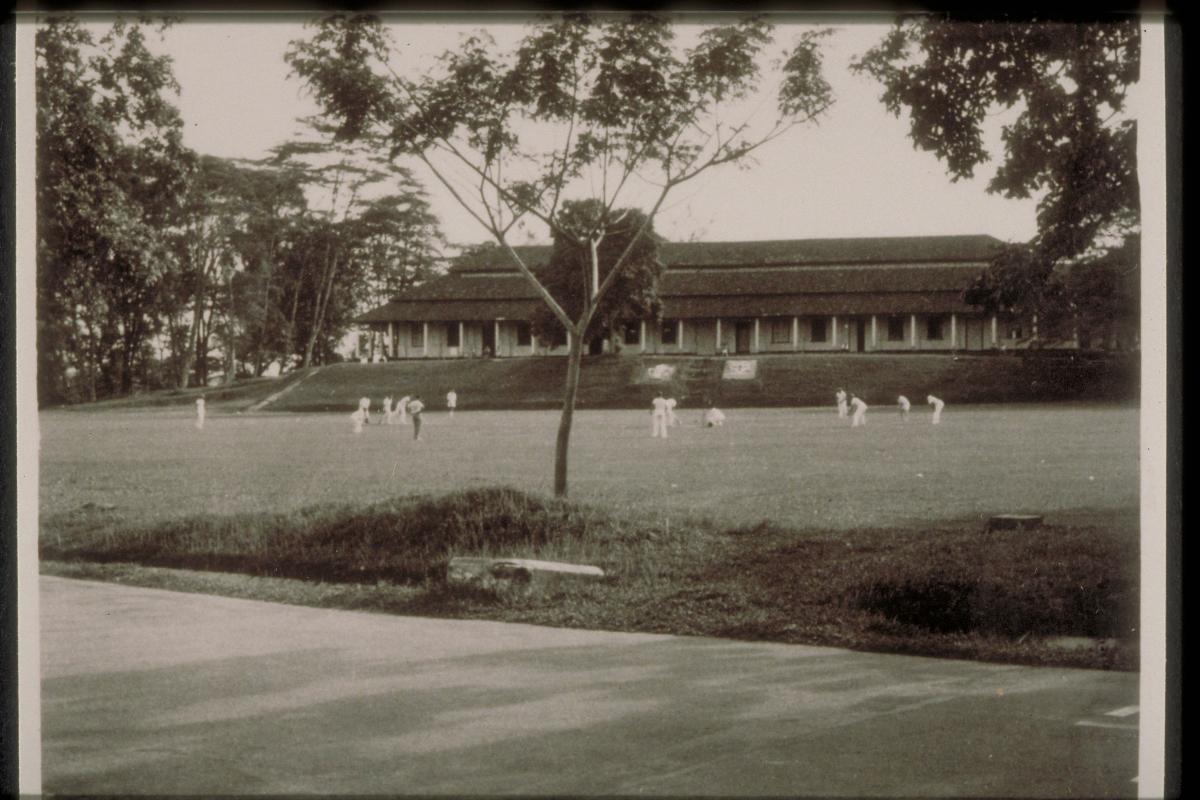

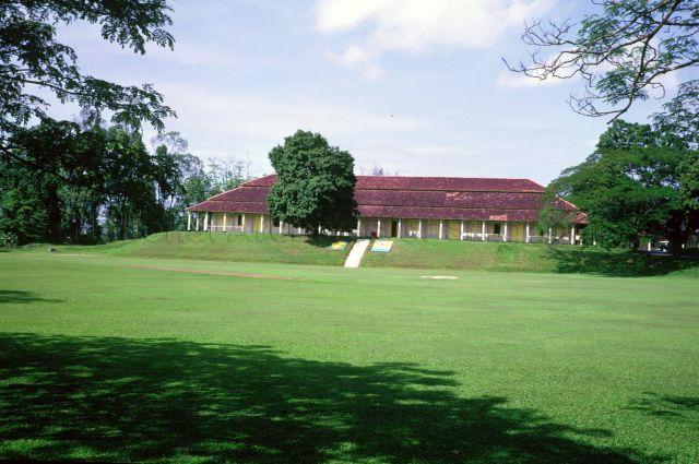


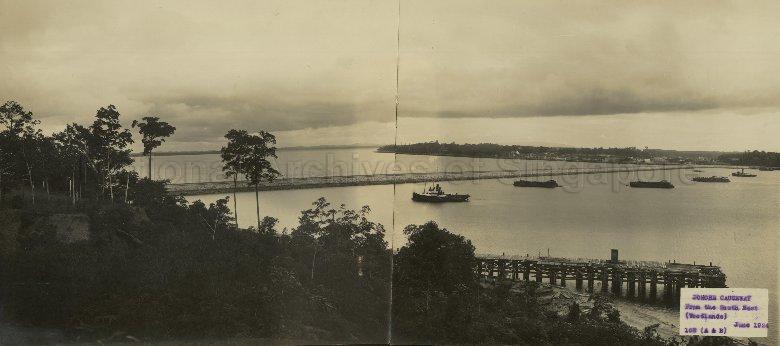


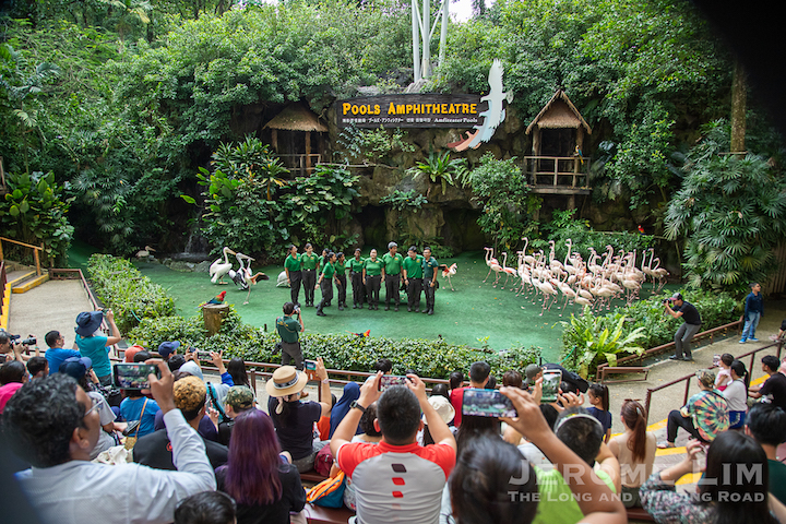


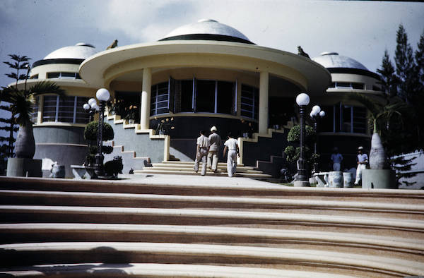


")


