 Highlights of a heritage tour of Sembawang, “Sembawang Beyond the Slumber”, with a focus on the Sembawang that I was familiar with in the 1970s. This was conducted through the Sembawang Public Library on 27 March 2011. The two and a half hour tour included a visit to the last kampung mosque in Singapore, as well as to several other points of interest in Sembawang:
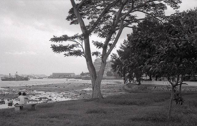
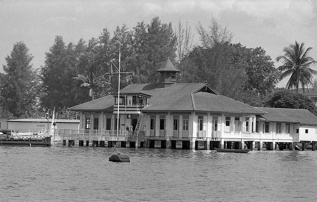
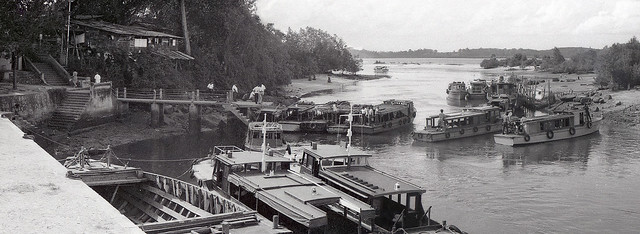
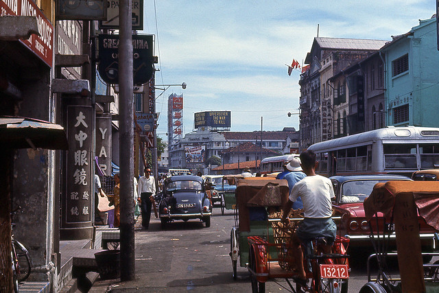
The Sembawang of the 1970s was a place that I spent many a happy moment at. Back then, it was a place that, as with many of the coastal areas of Singapore, had the air of a sleepy part of Singapore where one could escape from the hustle and bustle of the urban world that I had in brought up in. The Mata Jetty at the end of Sembawang Road had then been the focal point of many of the seemingly long journeys to the northern most area of Singapore, dominated then (as it is now) by the huge shipyard around which life seemed in those northern part, to revolve around.

The destination that first brought me in contact with the post Naval Base Sembawang of the 1970s, the Mata Jetty.
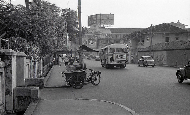
The shipyard was to many who lived in the area, a source of sustenance, having provided a living to many who settled in the area since it started life as the repair dockyard of the largest Naval Base east of the Suez (said to have enough berthing space to take in the entire Royal Navy fleet at that time) over the 1920s culminating in the opening of the dockyard’s graving dock in 1938. Opened by the then Governor of Singapore, Sir Shenton Thomas on 14 February 1938, the King George VI dock (fondly referred to as KG6), was then the largest ever naval graving dock, one which is still very much in use today. The establishment of the dockyard had been a godsend, coming at the time when a slump in rubber prices meant that many who worked in the area which had depended very much on the rubber plantations introduced by Lim Nee Soon would have had an uncertain future. The dockyard attracted many from far and wide and was responsible for the establishment of the largest community of Malayalees in Singapore in the north. The announcement of the pullout of the British forces in 1968 had cast a shadow of doubt on the future for many who worked there as well as in many of the military bases around the island, coming at a time when a newly independent Singapore was struggling to find its feet, with the bases combined contributing to 20% of Singapore’s GNP. The establishment of a commercial shipyard on the site of the dockyard (the dockyard was transferred to the Singapore government for a token fee of $1) on 19 June 1968, had however, secured the future for many.

The shipyard which was established on the site of the former naval dockyard brought much life to the areas around Sembawang in the 1970s.
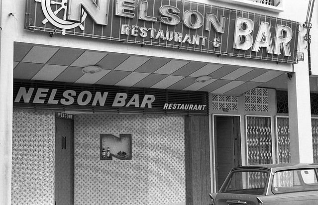
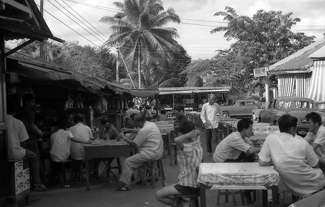
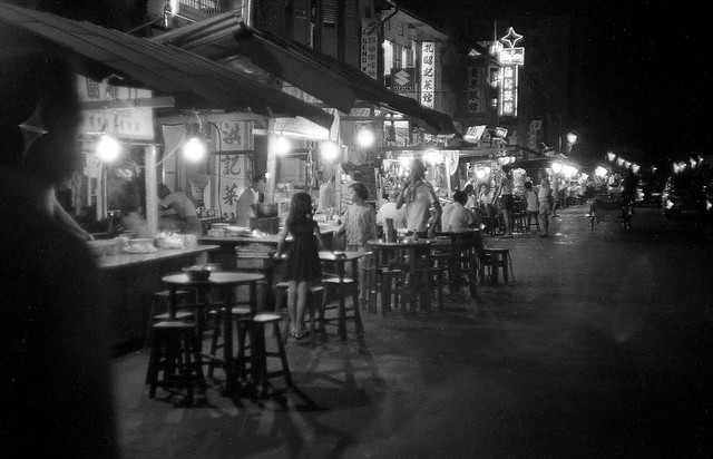
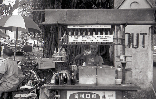
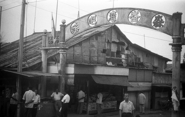
By the time I started frequenting the jetty, the British had disappeared, and the ANZUK forces installed in place. By the time 1974 arrived, it was only the New Zealand Force SEA that was left with the withdrawal of the Australian Forces, and their presence didn’t go unnoticed in the area – with “The Strip” – a row of shop houses at Sembawang Village which contained several watering holes including the popular Nelson Bar being a popular hangout. Sembawang Village , established outside the Naval Base’s Sembawang Gate on Admiralty Road had several “makan stalls” including a row of Indian stalls that was popular for Mee Goreng as well as having hosted a bicycle shop that perhaps supplied the families of the many British, Australian and New Zealand military personnel that passed through the area, Cheap John’s which is still in the area – further down Sembawang Road close to Sembawang Shopping Centre.

Sembawang Village grew on the outside of the Sembawang Gate of the former Naval Base, catering to many who lived on the base (Courtesy of Mr Derek Tait).

“The Strip” around Sembawang Village, provided watering holes for the many foreign servicemen in the area, which included the popular Nelson Bar.

“The Strip” seen in the 1970s (Source: ANZ Military Brats of Singapore).

Sembawang Village was also where Cheap John’s – a popular bicycle shop started some 40 years ago, was located. The shop is still around, currently located further south along Sembawang Road close to Sembawang Shopping Centre (Source: ANZ Military Brats of Singapore).

Cheap John’s at its current location is still very much a source of bicycles for Sembawang residents.
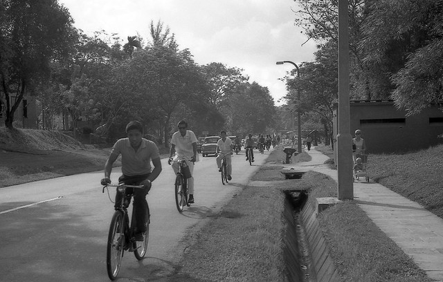
Despite the presence of the foreign military personnel, it was probably the workers of the shipyard that were responsible for perhaps rousing Sembawang from its slumber in the 1970s, bringing much colour and life not just to the villages that provided housing to many of them, but also to the streets around. One of the sights that greeted the early morning scene along the narrow Canberra Road that wove its way past the old Canberra Gate (another of the former gates of the Naval Base), of which one concrete pillar remained close to a bus stop that always looked busy with the comings and goings of the many schoolchildren who attended the few schools along the road, and the extended Chong Pang Village which grew to the west of Canberra Road all the way to the marshy land on the banks of the Sungei Sembawang, was that of the convoy of bicycles, their riders in the colourful overalls marked with the seahorses that Sembawang Shipyard had adopted as its logo.
")
Canberra Gate along Canberra Road in 1968 – near the junction with Sembawang Road. (Courtesy of Mr Derek Tait)

A scene reminiscent of the Sembawang of the 1970s and 1980s – the stream of bicycles along a part of Canberra Road that has remained relatively unchanged.
Along Canberra Road across from the area where Sembawang Mart is today, the sight of a Hindu temple set in a clearing would greet the traveller. That was what was the original Holy Tree Sri Balasubramaniar Temple built in the 1960s around an altar to Lord Murugan set up by a dockyard worker. It was at this temple where a annual festival which provided the area with much colour, Panguni Uthiram, involving a procession of a chariot and a kavadi procession, was first celebrated in the area in 1967, a tradition which continues till today, with the temple having moved to a new location in Yishun Industrial Park A in the 1990s.

The area still plays host to the annual Panguni Uthiram festival, which now takes a different route. The festival was first celebrated at the old temple in 1967.
There were several other houses of worship which rose up prominently along some of the main roads of the area as well: the distinctive St. Andrew’s Church, built in 1963 to serve British Military personnel in the area along Admiralty Road close to what had been Sembawang Gate, which is still around; Masjid Naval Base which was close to the junction of Delhi Road and Canberra Road (since demolished); and the Church of Our Lady Star of the Sea (now in Yishun) at the corner where Canberra Road branched off from Sembawang Road. One that was in an obscure location – nestled in the wooded coastal kampung area to the east of what is today Sembawang Park, in the Malay Settlement, Kampong Tengah, established by the British to house Malay dockyard workers, the Masjid Petempatan Melayu, built from the 1960s right up to the 1970s when the bulk of it was completed, is also still around in a setting very much unchanged (except that the kampung around it has since deserted it), having been granted an extended lease of life on a temporary basis. What the future holds for the mosque, dubbed the “Last Kampung Mosque in Singapore”, no one really knows, as Mdm. Zaleha of the mosque’s management committee laments … Today, the mosque comes alive during the school holidays, with camps run by the mosque for Muslim schoolchildren being a popular activity. One of the participants of the walk thought that it would be a nice idea to set up a holiday campsite in the area for schoolchildren of other religions as well.

Masjid Petempatan Melayu Sembawang – the last kampung mosque in a kampung setting.
")
Mdm. Zaleha of the Mosque’s Management Committee speaking to two of the participants.
Around the St. Andrew’s Church is the area dominated by the stately residences of the military personnel, many of which were built in the 1920s and 1930s as the Naval Base came up, both to the north of Admiralty Road all the way to the coast, and to the south towards Canberra Road. Many of the houses, referred to as “Black and White” houses for the way in which they are painted, are still there today, housing military personnel from the US Navy’s Logistics Base which now occupies part of what was the Stores Basin of the Naval Base just west of Sembawang Park. The former Stores Basin is also occupied in part by the Sembawang Wharves, run by the Port of Singapore Authority (PSA), established in the 1970s when it was vacated by the British. Sembawang Wharves had since been associated with timber, rubber and container imports, as well as being at one time one of the entry point for cars imported to Singapore.

St. Andrew’s Church, built in 1963 for the British Military personnel and their families.

Sembawang has a generous distribution of “Black and White” houses built in the 1920s and 1930s to house military personnel and their families.

The Stores Basin seen in 1962 (source: http://www.singas.co.uk). Part of it is used as a US Navy Logistics Base and the rest is part of PSA’s northern gateway, Sembawang Wharves.
In the cluster of Black and White houses south of the park, along Gibraltar Crescent, there is an interesting find – an entrance to a bunker engulfed by a Banyan Tree that has grown over it – a scene similar to that which greets a visitor at the ruins of the Ta Prohm temple complex in Siem Reap. Bunkers were commonly found nestled amongst the houses – most have been covered over now, including one at Gibraltar Crescent of which the only evidence left is a grass mound, as is one that used to greet the eye behind Beaulieu House.

The entrance of a WWII bunker engulfed by a Banyan tree along Gibraltar Crescent.

Another view of the bunker’s entrance.
Speaking of Beaulieu House, it is one of a few buildings in the area with conservation status, having been granted that in 2005. Built as a seaside home of a wealthy plantation owner in the early 1900s, it was acquired by the British military as the Naval Base was being built, serving as a home for the engineers and later for senior naval officers and it is mentioned that from 1940 to 1942, an Admiral Geoffrey Layton, the Commander-in-Chief for Britain’s China station stayed at the house and the house was occupied by Senior Fleet Officers after the war. The URA’s write-up on the house mentions that the name was derived from a certain Admiral Beaulieu, a Chief of Staff of the Royal Navy, but makes no mention of whether he stayed there.

Beaulieu House started life as a seaside home of a wealthy plantation owner, before being taken over by the British as the Naval Base was being constructed in the 1920s. Beaulieu House was included URA’s conservation list in 2005.
Beaulieu House, overlooks what was referred to in the 1970s as the Mata Jetty, being located at the end of Mata Road, which took one past two Muslim graves at a bend under a tree close to the fence line of the former Stores Basin. The jetty brings with it many memories of the smell of rotting fish used as bait in square bamboo framed crab traps weighed down by lead weights wrapped at each of its four ends of the frame, tied to the jetty with nylon or raffia twine. What comes back as well to me are the burnt planks and the railing-less sides and end off which a car was driven off at high speed in 1975. The waters around the jetty were great for harvesting shrimps with butterfly nets while wading in the eel and puffer fish infested waters. The shrimps eyes stood out when a light was shone in the water and that enabled one with a quick hand to scoop them out with the net. These often ended up over an open fire which we often built on the beach – the smell of fresh seafood over the fire and the crackling sounds that accompanied them as they cooked are still fresh in my memory.

Beaulieu House overlooks the Mata Jetty which was built in the 1940s and is today a popular jetty for fishing and crabbing.
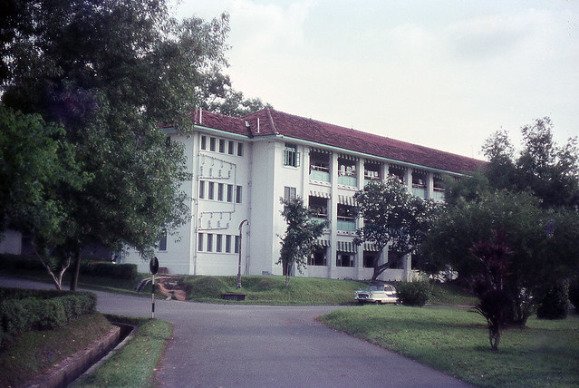
Other buildings in the area which have some form of conservation status include Old Admiralty House which has been gazetted as a National Monument in 2002, and the former Sembawang Fire Station which was given conservation status in 2007, both of which we did not visit due to physical limitations. Old Admiralty House on Old Nelson Road (just across Canberra Road from Sembawang MRT Station), a two-storey brick bungalow housed the Commodore, Malaya and Officer in Charge of His Majesty’s Naval Establishments in Singapore.Constructed in 1939, iIt was later used as was the official residence of the Commander-in-Chief, Far East Station from 1958 up until 1971, when it was named Admiralty House. The URA also provides some information on the former Sembawang Fire Station (which is now within the grounds of Sembawang Shipyard): “built in the 1930s, this two-storey concrete building is designed in a simplified Art Deco-Modern style and has an elegantly proportioned fire-hose tower. The building is a local landmark for both the Sembawang area and the Shipyard”.

Admiralty House, built to house the Commodore Superintendent of the Dockyard and later used to house the Commander-in-Chief of the Royal Navy’s Far East Station was gazetted a National Monument in 2002.

Another building with conservation status is the former Sembawang Fire Station built in the 1930s with its distinctive fire hose tower. The building is within the premises of Sembawang Shipyard.
The last stop was perhaps the highlight for many, a visit to the site of the hot springs that has long been associated with the area. The hot springs, dubbed “Sembawang Hot Springs” was for much of my younger days, associated with the Seletaris bottling plant that came up in 1967 under a subsidiary of soft drink giant Fraser and Neave (F&N), Semangat Ayer Limited. The existence of the spring, based on a heritage guide published by the HDB and the National Heritage Board, had been known as far back as 1908 (which a book written by Song Ong Siang, “One Hundred Years of the Chinese in Singapore” puts as 1909), when a Municipal ranger called W. A. B. Goodall discovered it. The land owner, a certain Mr Seah Eng Keong proceeded to start bottling the water under the brand “Zombun” soon after, after he had established that it was safe to drink, establishing the Singapore Natural Mineral Hot Springs Company. F&N bought the company over in 1921 and bottled the water right up to the war under several brands which included “Zom”, “Salitaris”, “Singa Water” and “Vichy Water” until the Japanese Occupation, during which the Japanese built thermal baths in the area. This was destroyed during an allied bombing raid on Singapore in November 1942 which interrupted the flow of the spring water to the surface and on advise of a geologist after the war, F&N left the spring until flow was naturally restored in the 1960s. When Semangat Ayer’s bottling plant was established in 1967, there had actually been plans to build a spa in the area – but that never took off, and bottling continued until the 1980s, when the land on which the spring was on was acquired by the Government to build an airbase. That would have sounded the death knell for the hot spring and if not for an outcry from the local community, we might have seen the last of the only hot springs on mainland Singapore. A corridor was built in 2002 within the perimeter of the airbase along Gambas Avenue leading to a concrete base with standpipes which channel the spring water to taps, allowing the public use of the hot spring which is thought to have curative properties for several ailments. As several of the participants were to find out, the water which reported flows out at 65 degrees Celcius, does, based on its acrid smell, have some Sulphur content which is said to be useful for the treatment of skin problems.

Sembawang Hot Springs was the source of Seletaris – a brand of mineral water bottled by F&N’s subsidiary, Semangat Ayer Limited up to the 1980s (source: http://www.picas.nhb.gov.sg).
The visit to the hot springs brought back memories of another part of Sembawang that I was fond of, one that was accessible through a road Jalan Ulu Sembawang that lay at the back of what is now the Seletaris Condominium complex, developed by F&N on the site of part of what had been the Seletaris Bottling plant. A little stub of the road is still left, but no more than that. The road had once provided access to a vast area of farmland and fishing ponds – rising up onto a crest of a hilly area that overlooked what had seemed like rolling plains of vegetable farms. My father had in the 1970s and 1980s been fond of driving along the road just for that view … one that I remember as being one of the most picturesque in Singapore. The road lead to the Lorong Gambas and Mandai area which many who did National Service in the 1970s and 1980s would remember for the training areas they contained. Like much of what was around Sembawang, that is now lost, as is the large Chong Pang village that dominated much of the are south of the Naval Base which was demolished in 1989 after residents moved out in 1986 or so. Much of the area now occupied by the new Sembawang HDB estate. The plot of land where the heart of Chong Pang was, the roundabout near which the Sultan Theatre stood and where some of the best food in Singapore could be found, still lies empty, with plans to build a sports complex over the area. While that has gone, there are still many reminders that remain – particularly the areas on which the Black and White houses are located, the jetty and of course the old kampung mosque. There are also some reminders of the traditions that existed, the stream (albeit a smaller one) of bicycles heading down Canberra Road being one … and there is the most colourful one of all – the procession of kavadis that still make its way down once a year … on a different route, but one that reminds us of what Sembawang is all about, beyond that apparent slumber.


")
")
")


")


