Motoring Days on Orchard Road

26 11 2020

It is hard to imagine it today, but Singapore’s famous main shopping street, Orchard Road, was once lined with car showrooms and motor workshops. Car brands such as Volkswagen, Mercedes Benz, Austin, Morris, Ford, Vauxhall, Fiat … and even Rolls Royce, had a presence there. It was certainly the go-to place to do a test drive and place an order for the still affordable family car, or to send the car for servicing and repair.

Orchard Motors, which was at the corner of Orchard and Bideford Road, became The Orchard in the early 1970s — the home of the (in)famous Tivoli Coffee House (Orchard Motors photo used with the kind permission of Mr Bryan Soh).

Two showrooms that were rather prominent in the regular journeys that I made as a child along Orchard Road between C K Tang and Cold Storage, were Champion Motors and Orchard Motors. Champion, which was then a dealer for Volkswagen is today where Lucky Plaza stands, while Orchard Motors — which dealt with Vauxhalls and Chevrolets, was first converted into The Orchard — a small shopping mall that was better known as the location of the (in)famous Tivoli Coffee House, before being replaced by the Paragon’s original wing.

The Orchard, seen with Lucky Plaza coming up on the site of the former Champion Motors showroom.

Today, only two buildings that bear testament to Orchard Road’s motoring past still stand. One is the wonderfully designed sunburst gabled no 14 to 20 Orchard Road — now used by MDIS, which has a history that goes back to Orchard Road’s early motoring days when it was purpose-built as showroom cum office building for Malayan Motors, a Morris dealer. That stands in a conserved row now opposite Dhoby Ghaut MRT Station — along a stretch of Orchard Road that attracted a host of showrooms and workshops in the early days of motoring and was where Ford motorcars were initially assembled in Singapore. Names such as Universal Cars, a Ford dealer and Borneo Motors, an Austin dealer turned Toyota agent, were also connected with the stretch.

The former Malayan Motors showroom seen in 1984 (courtesy of Henry Cordeiro).

While it does seem quite well established that the former Malayan Motors showroom is still around, much less has been said about Liat Towers, which was constructed as the headquarters and showroom of Mercedes Benz. Its construction came at a time when the street was on the cusp of its transformation into the world-renowned retail destination that it is today. It would not be long before shopping malls such as Plaza Singapura (1974) and Lucky Plaza (1978) launched the transformation of the street into a retail destination.


The ‘sunken temple’ of Toa Payoh

18 09 2013

A curious sight that greeted anyone travelling down Lorong 6 close to the Temple / Kim Keat Estate area of Toa Payoh in its early days and one I well remember was a temple that at road level, appeared to be have buried in the ground. The temple, Poh Tiong Keng 普忠宫 (Pu Zhong Gong), which I would refer to as the ‘sunken temple’, was one which went back to the village origins of the area, well before the towering public housing blocks of flats arrived.

The only photograph I have managed to find of the Poh Tien Keong with Block 33 seen behind it (online photograph at http://aliciapatterson.org/stories/aged-singapore-veneration-collides-20th-century).

The area where the 'Poh Tien Keong was as seen today.

The area where the ‘Poh Tien Keong was as seen today.

The Block 33 view of the area where the 'sunken temple' was.

The Block 33 view of the area where the ‘sunken temple’ was.

Set in what would have been an undulating area, the levelling of the surrounding ground to put up blocks of flats in the late 1960s, it found itself in a hole in the ground with the 11 storey block 33 towering above it, surrounded by retaining walls put up by the Housing and Development Board (HDB) to protect the temple from being buried. The temple was one of three existing temples which were left untouched by the HDB in clearing the land in the area for the development of the new housing estate. The other two were the Siong Lim Temple and the  Seu Teck Sean Temple.

The temple finding itself in a hole in the ground as work on the new public housing estate of Toa Payoh was being carried out in 1968.

The temple finding itself in a hole in the ground as work on the new public housing estate of Toa Payoh was being carried out in 1968 (Source: online catalogue of the National Archives of Singapore http://www.nas.gov.sg/archivesonline/).

Another photograph taken during the development of Toa Payoh in 1968.

Another photograph taken during the development of Toa Payoh in 1968 (Source: online catalogue of the National Archives of Singapore http://www.nas.gov.sg/archivesonline/).

Sadly the sight is one we no longer see. The temple was demolished in late 1977, not long after I moved out of Toa Payoh. The area where the temple was will now also see a huge change – the block of flats behind where the temple was along with several others in the area – some of which were leased out temporarily to Resorts World Sentosa to house their workers after residents were moved out, are due to be demolished (one of the blocks which will be demolished is Block 28, in front of which the iconic dragon of  Toa Payoh can be found).

The hole in the ground after the temple was demolished in 1977 (Source: online catalogue of the National Archives of Singapore http://a2o.nas.sg/picas/)

The hole in the ground after the temple was demolished in 1977 (Source: online catalogue of the National Archives of Singapore http://www.nas.gov.sg/archivesonline/)

A last look around Block 33

JeromeLim 277A2174

JeromeLim 277A2170

JeromeLim 277A2189

JeromeLim 277A2190

JeromeLim 277A2193

JeromeLim 277A2196

JeromeLim 277A2199


Afternote:

It has been brought to my attention that the Poh Tiong Beo (普忠庙) located diagonally across the road from this site was built to replace the ‘sunken temple’ as drainage was poor in the recess the original temple sat in and that would get flooded everytime it rained heavily.


The swastika at the tenth mile

9 07 2013

One very distinct memory from a childhood of many wonderful moments to remember is of the red swastika at Somapah Village. The village was one I had many encounters with in the late 1960s and very early 1970s, stopping by or passing through it on the many journeys we made to Mata Ikan at the other end of Somapah Road where a favourite holdiay destination for my family – the Mata Ikan Government Holiday Bungalows was located.

A photograph of the old Red Swastika School along Somapah Road (source: Red Swastika School's website).

The red swastika along Somapah Road (source: Red Swastika School’s website).

The swastika belonged to the Red Swastika School, just down the road from the main part of the village. It adorned the simple single storey zinc-roofed  school building, rising above it over the entrance and never failed to catch my attention from my vantage in the back seat of the car – a symbol I would always associate with the now lost village. The memories I do have of the village and the school are largely contained in a post I had put up at the end of 2010 on the village:  Memories of the lost world that was Somapah Village. What motivated me to touch on this again is a few old photographs of the school, apparently taken during a school sports day in the 1970s, sent by a reader Mr. Alvin Lee, which follows.

10

5

The school traces its history back to the founding of the Wan Tzu School by the World Red Swastika Society at the village in 1951, built to serve residents of the rural community in the Changi 10th Mile area where Somapah Village was located and provided free education to them. Sometime in the 1950s, the name of the school was changed to the Red Swastika School – a name now well respected for its academic achievements.  Its enrollment was to grow quickly, from 300 at its starting, it had by the end of its first decade a population of some 1000 students who were accommodated in its 12 classrooms over two sessions. With the days of the village coming to an end in the 1980s the school moved to new premises in Bedok North Avenue 3 in 1981 where it still operates today.

6

7


A church once occupied by Sin

19 03 2013

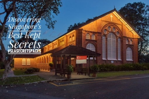
I took a walk by what, for a short moment, appeared to be a church in the woods. In an area in which woods in any form would have long abandoned – the corner of Waterloo Street and Middle Road, the building which resembles a small village church has for the better part of a century not actually used as one. Together with an adjacent two storey building, the church is now part of the Sculpture Square complex, a space dedicated to the promotion and development of contemporary 3-dimensional (3D) art.

A church in the woods?

A church in the woods?

My memories of the buildings are ones which date back to my younger days (of which I have actually written about in a previous post). The church building itself was always a curious sight each time I passed through the area, whether on the way home from church in the late 1960s and early 1970s, or from school in the late 1970s, when it had been occupied by Sin. The walls of the building were then coloured not just by the colour of its fading coat of paint, but also by streaks of motor oil and grease, having been used by a motor workshop, the Sin Sin Motor Co. My mother remembers it being used as a motor workshop as far back as her own days in school (she went to St. Anthony’s Convent further down Middle Road in the 1950s). The building next to it, which is built in a similar layout as many in the area which might ones which have been homes of wealthy merchants, had in those days been used as the Tai Loke Hotel (previously Tai Loke Lodging House) – one of several rather seedy looking budget hotels found in the area.

The church building when it was used as a motor workshop and the Tai Loke Hotel next to it, 1987 (source: http://a2o.nas.sg/picas/)

The church building when it was used as a motor workshop and the Tai Loke Hotel next to it, seen from Middle Road in 1987 (source: http://a2o.nas.sg/picas/).

While not much is known about the building which the Tai Loke occupied, there is enough that is known about the church building which was erected from 1870 to 1875, based on information on a National Heritage Board (NHB) plaque at the site as well as on Sculpture Square’s website. It first saw use as the Christian Institute. The Methodists were in 1885, invited to use the building and it became the Middle Road Church (or Malay Church) after a transfer to the Methodists was made in 1892, until the church moved to Kampong Kapor in 1929. Interestingly, the building also housed the Methodist Girls’ School which was started at nearby Short Street for a while until 1900. According to information on Sculpture Square’s website, the building had apparently also seen life as a Chinese restaurant, the “May Blossom Restaurant” during the war.

A photograph of the abandoned church building in the 1990s - after the motor workshop had vacated it (from Sculpture Square's website).

A photograph of the abandoned church building in the 1990s – after the motor workshop had vacated it (from Sculpture Square’s website).

Following years of neglect, the former church building when it was vacated by the motor workshop possibly at the end of the 1980s, was left in rather a dilapidated condition and it was a local sculptor, Sun Yu Li, who saw its potential for use as an arts venue which was opened as Sculpture Square in 1999.


Sembawang beyond the slumber

29 03 2011

Highlights of a heritage tour of Sembawang, “Sembawang Beyond the Slumber”, with a focus on the Sembawang that I was familiar with in the 1970s. This was conducted through the Sembawang Public Library on 27 March 2011. The two and a half hour tour included a visit to the last kampung mosque in Singapore, as well as to several other points of interest in Sembawang:


The Sembawang of the 1970s was a place that I spent many a happy moment at. Back then, it was a place that, as with many of the coastal areas of Singapore, had the air of a sleepy part of Singapore where one could escape from the hustle and bustle of the urban world that I had in brought up in. The Mata Jetty at the end of Sembawang Road had then been the focal point of many of the seemingly long journeys to the northern most area of Singapore, dominated then (as it is now) by the huge shipyard around which life seemed in those northern part, to revolve around.

The destination that first brought me in contact with the post Naval Base Sembawang of the 1970s, the Mata Jetty.

The shipyard was to many who lived in the area, a source of sustenance, having provided a living to many who settled in the area since it started life as the repair dockyard of the largest Naval Base east of the Suez (said to have enough berthing space to take in the entire Royal Navy fleet at that time) over the 1920s culminating in the opening of the dockyard’s graving dock in 1938. Opened by the then Governor of Singapore, Sir Shenton Thomas on 14 February 1938, the King George VI dock (fondly referred to as KG6), was then the largest ever naval graving dock, one which is still very much in use today. The establishment of the dockyard had been a godsend, coming at the time when a slump in rubber prices meant that many who worked in the area which had depended very much on the rubber plantations introduced by Lim Nee Soon would have had an uncertain future. The dockyard attracted many from far and wide and was responsible for the establishment of the largest community of Malayalees in Singapore in the north. The announcement of the pullout of the British forces in 1968 had cast a shadow of doubt on the future for many who worked there as well as in many of the military bases around the island, coming at a time when a newly independent Singapore was struggling to find its feet, with the bases combined contributing to 20% of Singapore’s GNP. The establishment of a commercial shipyard on the site of the dockyard (the dockyard was transferred to the Singapore government for a token fee of $1) on 19 June 1968, had however, secured the future for many.

The shipyard which was established on the site of the former naval dockyard brought much life to the areas around Sembawang in the 1970s.

The Dockyard’s gates seen in the 1960s (source: http://www.singas.co.uk).

By the time I started frequenting the jetty, the British had disappeared, and the ANZUK forces installed in place. By the time 1974 arrived, it was only the New Zealand Force SEA that was left with the withdrawal of the Australian Forces, and their presence didn’t go unnoticed in the area – with “The Strip” – a row of shop houses at Sembawang Village which contained several watering holes including the popular Nelson Bar being a popular hangout. Sembawang Village , established outside the Naval Base’s Sembawang Gate on Admiralty Road had several “makan stalls” including a row of Indian stalls that was popular for Mee Goreng as well as having hosted a bicycle shop that perhaps supplied the families of the many British, Australian and New Zealand military personnel that passed through the area, Cheap John’s which is still in the area – further down Sembawang Road close to Sembawang Shopping Centre.

Sembawang Village grew on the outside of the Sembawang Gate of the former Naval Base, catering to many who lived on the base (Courtesy of Mr Derek Tait).
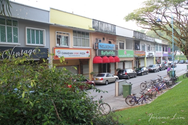
“The Strip” around Sembawang Village, provided watering holes for the many foreign servicemen in the area, which included the popular Nelson Bar.

“The Strip” seen in the 1970s (Source: ANZ Military Brats of Singapore).
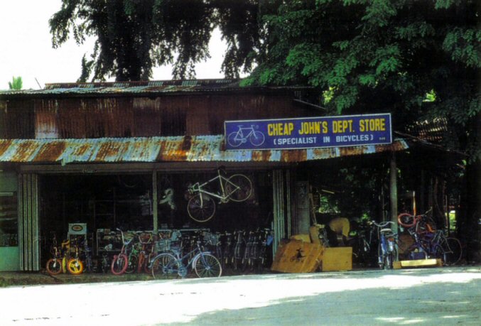
Sembawang Village was also where Cheap John’s – a popular bicycle shop started some 40 years ago, was located. The shop is still around, currently located further south along Sembawang Road close to Sembawang Shopping Centre (Source: ANZ Military Brats of Singapore).

Cheap John’s at its current location is still very much a source of bicycles for Sembawang residents.

Despite the presence of the foreign military personnel, it was probably the workers of the shipyard that were responsible for perhaps rousing Sembawang from its slumber in the 1970s, bringing much colour and life not just to the villages that provided housing to many of them, but also to the streets around. One of the sights that greeted the early morning scene along the narrow Canberra Road that wove its way past the old Canberra Gate (another of the former gates of the Naval Base), of which one concrete pillar remained close to a bus stop that always looked busy with the comings and goings of the many schoolchildren who attended the few schools along the road, and the extended Chong Pang Village which grew to the west of Canberra Road all the way to the marshy land on the banks of the Sungei Sembawang, was that of the convoy of bicycles, their riders in the colourful overalls marked with the seahorses that Sembawang Shipyard had adopted as its logo.

Canberra Gate along Canberra Road in 1968 – near the junction with Sembawang Road. (Courtesy of Mr Derek Tait)

A scene reminiscent of the Sembawang of the 1970s and 1980s – the stream of bicycles along a part of Canberra Road that has remained relatively unchanged.

Along Canberra Road across from the area where Sembawang Mart is today, the sight of a Hindu temple set in a clearing would greet the traveller. That was what was the original Holy Tree Sri Balasubramaniar Temple built in the 1960s around an altar to Lord Murugan set up by a dockyard worker. It was at this temple where a annual festival which provided the area with much colour, Panguni Uthiram, involving a procession of a chariot and a kavadi procession, was first celebrated in the area in 1967, a tradition which continues till today, with the temple having moved to a new location in Yishun Industrial Park A in the 1990s.

The old Holy Tree Sri Balasubramaniar Temple off Canberra Road (source: http://www.picas.nhb.gov.sg).

The area still plays host to the annual Panguni Uthiram festival, which now takes a different route. The festival was first celebrated at the old temple in 1967.

There were several other houses of worship which rose up prominently along some of the main roads of the area as well: the distinctive St. Andrew’s Church, built in 1963 to serve British Military personnel in the area along Admiralty Road close to what had been Sembawang Gate, which is still around; Masjid Naval Base which was close to the junction of Delhi Road and Canberra Road (since demolished); and the Church of Our Lady Star of the Sea (now in Yishun) at the corner where Canberra Road branched off from Sembawang Road. One that was in an obscure location – nestled in the wooded coastal kampung area to the east of what is today Sembawang Park, in the Malay Settlement, Kampong Tengah, established by the British to house Malay dockyard workers, the Masjid Petempatan Melayu, built from the 1960s right up to the 1970s when the bulk of it was completed, is also still around in a setting very much unchanged (except that the kampung around it has since deserted it), having been granted an extended lease of life on a temporary basis. What the future holds for the mosque, dubbed the “Last Kampung Mosque in Singapore”, no one really knows, as Mdm. Zaleha of the mosque’s management committee laments … Today, the mosque comes alive during the school holidays, with camps run by the mosque for Muslim schoolchildren being a popular activity. One of the participants of the walk thought that it would be a nice idea to set up a holiday campsite in the area for schoolchildren of other religions as well.

Masjid Petempatan Melayu Sembawang – the last kampung mosque in a kampung setting.

Mdm. Zaleha of the Mosque’s Management Committee speaking to two of the participants.

Around the St. Andrew’s Church is the area dominated by the stately residences of the military personnel, many of which were built in the 1920s and 1930s as the Naval Base came up, both to the north of Admiralty Road all the way to the coast, and to the south towards Canberra Road. Many of the houses, referred to as “Black and White” houses for the way in which they are painted, are still there today, housing military personnel from the US Navy’s Logistics Base which now occupies part of what was the Stores Basin of the Naval Base just west of Sembawang Park. The former Stores Basin is also occupied in part by the Sembawang Wharves, run by the Port of Singapore Authority (PSA), established in the 1970s when it was vacated by the British. Sembawang Wharves had since been associated with timber, rubber and container imports, as well as being at one time one of the entry point for cars imported to Singapore.

St. Andrew’s Church, built in 1963 for the British Military personnel and their families.

Sembawang has a generous distribution of “Black and White” houses built in the 1920s and 1930s to house military personnel and their families.

The Stores Basin seen in 1962 (source: http://www.singas.co.uk). Part of it is used as a US Navy Logistics Base and the rest is part of PSA’s northern gateway, Sembawang Wharves.

In the cluster of Black and White houses south of the park, along Gibraltar Crescent, there is an interesting find – an entrance to a bunker engulfed by a Banyan Tree that has grown over it – a scene similar to that which greets a visitor at the ruins of the Ta Prohm temple complex in Siem Reap. Bunkers were commonly found nestled amongst the houses – most have been covered over now, including one at Gibraltar Crescent of which the only evidence left is a grass mound, as is one that used to greet the eye behind Beaulieu House.

The entrance of a WWII bunker engulfed by a Banyan tree along Gibraltar Crescent.

Another view of the bunker’s entrance.

Speaking of Beaulieu House, it is one of a few buildings in the area with conservation status, having been granted that in 2005. Built as a seaside home of a wealthy plantation owner in the early 1900s, it was acquired by the British military as the Naval Base was being built, serving as a home for the engineers and later for senior naval officers and it is mentioned that from 1940 to 1942, an Admiral Geoffrey Layton, the Commander-in-Chief for Britain’s China station stayed at the house and the house was occupied by Senior Fleet Officers after the war. The URA’s write-up on the house mentions that the name was derived from a certain Admiral Beaulieu, a Chief of Staff of the Royal Navy, but makes no mention of whether he stayed there.

Beaulieu House started life as a seaside home of a wealthy plantation owner, before being taken over by the British as the Naval Base was being constructed in the 1920s. Beaulieu House was included URA’s conservation list in 2005.

Beaulieu House, overlooks what was referred to in the 1970s as the Mata Jetty, being located at the end of Mata Road, which took one past two Muslim graves at a bend under a tree close to the fence line of the former Stores Basin. The jetty brings with it many memories of the smell of rotting fish used as bait in square bamboo framed crab traps weighed down by lead weights wrapped at each of its four ends of the frame, tied to the jetty with nylon or raffia twine. What comes back as well to me are the burnt planks and the railing-less sides and end off which a car was driven off at high speed in 1975. The waters around the jetty were great for harvesting shrimps with butterfly nets while wading in the eel and puffer fish infested waters. The shrimps eyes stood out when a light was shone in the water and that enabled one with a quick hand to scoop them out with the net. These often ended up over an open fire which we often built on the beach – the smell of fresh seafood over the fire and the crackling sounds that accompanied them as they cooked are still fresh in my memory.

Beaulieu House overlooks the Mata Jetty which was built in the 1940s and is today a popular jetty for fishing and crabbing.

Other buildings in the area which have some form of conservation status include Old Admiralty House which has been gazetted as a National Monument in 2002, and the former Sembawang Fire Station which was given conservation status in 2007, both of which we did not visit due to physical limitations. Old Admiralty House on Old Nelson Road (just across Canberra Road from Sembawang MRT Station), a two-storey brick bungalow housed the Commodore, Malaya and Officer in Charge of His Majesty’s Naval Establishments in Singapore.Constructed in 1939, iIt was later used as was the official residence of the Commander-in-Chief, Far East Station from 1958 up until 1971, when it was named Admiralty House. The URA also provides some information on the former Sembawang Fire Station (which is now within the grounds of Sembawang Shipyard): “built in the 1930s, this two-storey concrete building is designed in a simplified Art Deco-Modern style and has an elegantly proportioned fire-hose tower. The building is a local landmark for both the Sembawang area and the Shipyard”.

Admiralty House, built to house the Commodore Superintendent of the Dockyard and later used to house the Commander-in-Chief of the Royal Navy’s Far East Station was gazetted a National Monument in 2002.

Another building with conservation status is the former Sembawang Fire Station built in the 1930s with its distinctive fire hose tower. The building is within the premises of Sembawang Shipyard.

The last stop was perhaps the highlight for many, a visit to the site of the hot springs that has long been associated with the area. The hot springs, dubbed “Sembawang Hot Springs” was for much of my younger days, associated with the Seletaris bottling plant that came up in 1967 under a subsidiary of soft drink giant Fraser and Neave (F&N), Semangat Ayer Limited. The existence of the spring, based on a heritage guide published by the HDB and the National Heritage Board, had been known as far back as 1908 (which a book written by Song Ong Siang, “One Hundred Years of the Chinese in Singapore” puts as 1909), when a Municipal ranger called W. A. B. Goodall discovered it. The land owner, a certain Mr Seah Eng Keong proceeded to start bottling the water under the brand “Zombun” soon after, after he had established that it was safe to drink, establishing the Singapore Natural Mineral Hot Springs Company. F&N bought the company over in 1921 and bottled the water right up to the war under several brands which included “Zom”, “Salitaris”, “Singa Water” and “Vichy Water” until the Japanese Occupation, during which the Japanese built thermal baths in the area. This was destroyed during an allied bombing raid on Singapore in November 1942 which interrupted the flow of the spring water to the surface and on advise of a geologist after the war, F&N left the spring until flow was naturally restored in the 1960s. When Semangat Ayer’s bottling plant was established in 1967, there had actually been plans to build a spa in the area – but that never took off, and bottling continued until the 1980s, when the land on which the spring was on was acquired by the Government to build an airbase. That would have sounded the death knell for the hot spring and if not for an outcry from the local community, we might have seen the last of the only hot springs on mainland Singapore. A corridor was built in 2002 within the perimeter of the airbase along Gambas Avenue leading to a concrete base with standpipes which channel the spring water to taps, allowing the public use of the hot spring which is thought to have curative properties for several ailments. As several of the participants were to find out, the water which reported flows out at 65 degrees Celcius, does, based on its acrid smell, have some Sulphur content which is said to be useful for the treatment of skin problems.

Sembawang Hot Springs was the source of Seletaris – a brand of mineral water bottled by F&N’s subsidiary, Semangat Ayer Limited up to the 1980s (source: http://www.picas.nhb.gov.sg).

The visit to the hot springs brought back memories of another part of Sembawang that I was fond of, one that was accessible through a road Jalan Ulu Sembawang that lay at the back of what is now the Seletaris Condominium complex, developed by F&N on the site of part of what had been the Seletaris Bottling plant. A little stub of the road is still left, but no more than that. The road had once provided access to a vast area of farmland and fishing ponds – rising up onto a crest of a hilly area that overlooked what had seemed like rolling plains of vegetable farms. My father had in the 1970s and 1980s been fond of driving along the road just for that view … one that I remember as being one of the most picturesque in Singapore. The road lead to the Lorong Gambas and Mandai area which many who did National Service in the 1970s and 1980s would remember for the training areas they contained. Like much of what was around Sembawang, that is now lost, as is the large Chong Pang village that dominated much of the are south of the Naval Base which was demolished in 1989 after residents moved out in 1986 or so. Much of the area now occupied by the new Sembawang HDB estate. The plot of land where the heart of Chong Pang was, the roundabout near which the Sultan Theatre stood and where some of the best food in Singapore could be found, still lies empty, with plans to build a sports complex over the area. While that has gone, there are still many reminders that remain – particularly the areas on which the Black and White houses are located, the jetty and of course the old kampung mosque. There are also some reminders of the traditions that existed, the stream (albeit a smaller one) of bicycles heading down Canberra Road being one … and there is the most colourful one of all – the procession of kavadis that still make its way down once a year … on a different route, but one that reminds us of what Sembawang is all about, beyond that apparent slumber.

The Ulu Sembawang area was very scenic with its rolling slopes of vegetable farms (source: http://www.picas.nhb.gov.sg)..

The area was also home to several fishing ponds (source: http://www.picas.nhb.gov.sg).


Memories of the lost world that was Somapah Village

16 12 2010

I have but vague memories of a world that once lay at the gateway to my playground by the sea. It was a world that now seems so distant in time and in space, and one that for me comes back in bits and pieces. That was the world that was once the bustling Somapah Village, located close to the 10th milestone of Changi Road, a place that was a major settlement in the area, deserving a mention in the RAF Information Booklet for New Arrivals for its Veterinary Clinic from which dog licenses could be obtained: “Travelling from Changi, Somapah Road is the first turning left after the overhead pedestrian crossing in Suicide Village – an off-white bungalow almost at the end of the road”.

Somapah Village was one of the main settlements in the area and served as the gateway to some of the villages that lay along the old coastline (source: National Archives).

My acquaintance with the village goes back to the early days of Singapore’s independence, when my parents who were in the civil service, made regular use of the Government holiday bungalows near Mata Ikan Village. Somapah Village was where Somapah Road met Upper Changi Road and served as a gateway to the coastal villages that lay to the south-east of it, including Mata Ikan, which was located a mile or so down the road at the coastal end of Somapah Road. Passing through the part of the village which had always seemed a hive of activity in the mornings was also the trigger for me to look out for the red swastika that would be perched on the top of a building, having developed a fascination for the symbol from the many encounters I had with the Nazis that had to do less with my overactive imagination than with the nightly dose of the exploits of Vic Morrow’s character Sgt. Saunders on Combat! The red swastika belonged to the Red Swastika School that was in a quiet part of the village along Somapah Road on the right as we made our way towards Mata Ikan, and was the left facing symbol used by the Taoist Red Swastika Society as opposed to the right facing swastika used by the Nazis, not that I noticed it then.

A photograph of the old Red Swastika School along Somapah Road (source: Red Swastika School's website).

Besides the memories of the red swastika, I do have some further memories of Somapah, two of which relate to visit to the GP’s clinic which was on the right side of the village along Somapah Road (facing south). What I can recollect was that it was perched on a raised area from the road, a unit in a row of shophouses. Both visits made to the GP were certainly painful ones, the first involved my mother who needed the GP’s attention to remove a fish hook which had lodged into the flesh around her knee as she climbed over a sea wall at Mata Ikan. The second was made for my benefit, one in which I sought relief from a painful encounter with the zipper of my shorts.

A scene from Somapah Village in 1986 - I believe the GP's clinic was in the row of shops in the background (source: National Archives).

It wasn’t so much the GP’s clinic that my earliest memories of the village were connected with. Those were of the market, which I believe was on the side opposite the shops where the GP’s clinic was located. It was where (the bungalows we holidayed at were self-catering and featured a well equipped kitchen), my mother would on every other day during our stays, shop for supplies of fresh produce and fish. We could of course rely on the mobile vendors: vegetables, fish, meat and eggs were sold from the back of a pick-up or a van that went from house to house, but the market always offered a much larger assortment. The market was where I had my earliest memories of seeing Sting Rays up close, displayed on the table of a fishmonger close to the entrance of the market. Being the inquisitive child that I was, the market was always a great source of fascination for me.

A barber's shop at Somapah Village (source: National Archives).

On the subject of mobile vendors, one that I was particularly fond of seeing was the bread vendor, who made an appearance every morning with his colourful display of bread dangling from a rack of sorts that was mounted on the back of a motorcycle. His arrival meant I could get my day’s supplies of the sweet grated coconut buns that I never could wait to sink my teeth into. Another one on two wheels that I would look out for would have been the milkman, with a milk can mounted at the back of his bicycle from which he would dispense milk in glass bottles. It is only very recently that I realised that the milk actually came from a dairy farm that was in Somapah Village itself – learning of the farm’s existence from an article on the ThinkQuest website.

A Chinese Temple (source: National Archives).

There are a few who remember the area having lived in the village, including a few readers who were kind enough to share their memories of Somapah on my post on Mata Ikan. One was a Mr Koh who described where the GP’s clinic I mentioned was: “The GP’s clinic was indeed situated close to a row of shophouses. It was located up a small slope called Jalan Somapah Timor. It was opened in 1962. Opposite the clinic and across the road was an open field with some cattle for diary purpose. Beside the clinic was a PAP kindergaten, my first school. Opposite it was a small police post. The market was an open-air market. Some of the vendors had shops with wooden top for their goods; the rest would place their items on ground sheets”. Another who goes by the moniker “sotong” added “my first sch was the PAP kindergarten too. i used to stayed in a house at jalan somapah timor, where the airport was separated from my place by a major road..still rem often seeing and hearing plane flying over my house. Also rem the days accompanying my mum to the market near my kumpung, eating chicken rice in this shop for i think 50cents per pack. but unfortunately i can’t rem exactly where my old house use to be located”.

Chinese Medicine Shop at Somapah Village (source: National Archives).

These days, there isn’t really much to remind us of that Somapah. The village and all around it has all but disappeared and only a few remnants of the area are left. Most of Somapah Road has gone, just a little maybe 50 metre stretch left of it located somewhere close to where Singapore Expo is off Changi South Avenue 1, relegated to a road that serves as a driveway to a car park. Across the road there are a few reminders of the time from which my experiences of Somapah Village were connected with including some of the roads such as Jalan Tiga Ratus and the buildings that were the former Changkat Changi Primary School that rose on a small hill along the Changi Road (now Upper Changi Road) next to Jalan Tiga Ratus which was built in the later half of the 1960s.

Across the road at Jalan Tiga Ratus, the buildings that were the Changkat Changi Secondary School (1st Photo) and Changkat Changi Primary School (2nd and 3rd Photo) built in the latter part of the 1960s still stand.

Across the road a big void greets the observer where once a bustling Somapah Road and Village had stood.

A gate stands across where Somapah Road had once run towards the coastal village of Mata Ikan.

What used to be Somapah Road near the junction with Upper Changi Road.

Where a village once stood ... now an empty field.


The little bit of Somapah Road that's left ... relegated to an access road for a car park.

A dead end for Somapah Road.

The view of the empty grassland from the south.


The second part of the walk down the Bukit Timah corridor: The mysteries around Hillview

24 10 2010

Leaving the compound of St. Joseph’s Church (Bukit Timah) with the sun peeking through the clouds, after a pause in our trek down Upper Bukit Timah Road, it was a good time to get reacquainted with the railway track side of the road. We crossed the overhead bridge which provided a wonderful vantage point from which I was able to take in the tremendous changes that the area, which lies in the shadow of Singapore’s tallest hill, Bukit Timah Hill, has seen over the three to four decades since I had first become acquainted with it. Somehow, it didn’t seem that long ago when I would view the area from the backseat of my father’s car en route to an adventure across the causeway or on a visit to the orchid nursery in the Teck Whye area which was run by a friend of my mother. There was a time as well – that would have been in the 1980s, when I did pass through the area on my own – on my way to a friend’s place up on Chestnut Drive, when the road was a lot narrower and the area around seemed a lot less built up.

The area where the tracks run opposite St. Joseph's Church.

After another pause at an area by the train tracks, accessible from the main road as what has become a popular short-cut had been trampled through the vegetation from Hillview Avenue, where we were able to have a wonderful view of what we could imagine of as a pass that was carved through a hill and where we were treated to a dash of bright blue in the form of a White-Throated Kingfisher perched on a branch of a tree by the tracks , we made our way south towards a building that had served for many years as a landmark in the area. The building is the Standard Chartered Bank branch building at the entrance to Hillview Road – a building from which I could count the number of bus stops to ensure I stopped at the correct one, on a side of the road that had once been devoid of any form of landmarks to identify where one was – especially in the dark of night. I would be always be reminded by my friend to stop at the second bus stop after seeing “Chartered Bank” – which had stood at the same spot – almost unchanged since it was first opened in April 1957.

A view of the "pass" near Hillview Avenue.

The tracks, looking north, near the shortcut to Hillview Avenue.

The Chartered Bank, a popularly referred to landmark in the area, as it looks today.

The Chartered Bank branch building at Bukit Timah seen at its opening on 6 April 1957 (source: The Free Press, 16 April 1957).

The view from Upper Bukit Timah Road of the entrance to Hillview Road had in itself, always interested me since the days of my backseat adventures. Hillview Road, and Hillview Avenue beyond it was one area that my father never seemed to go through. Looking through the narrow passage under the concrete supports of the railway girder bridge that runs across Hillview Road – always seemed to somehow suggest a sense of mystery of what lay beyond – the rise of the road beyond the bridge obscuring what lay beyond the little that was visible through the passage under the bridge. It was only much later in life that I actually discovered, to a sense of disappointment, what had lay beyond the bridge, on a visit to the Lam Soon Building during the early days of my working life. Later – the road would be one that I would become familiar with, on the many visits made during the course of my work to the installation that stands at the top of Bukit Gombak. By that time of course, much of the area that had in fact been one that was home to many factories in my days of adventure, being where the likes of the Union Carbide and Castrol factories had been located – had been turned into an area where many new sought after private condominiums had sprung up.

The narrow passage under the girder bridge at Hillview Road always seemed to suggest what lay beyond it was a mystery.

On top of the girder bridge at Hillview Road.

The other side of the "pass" near Hillview Avenue.

A scene of what's left of rural Singapore ... found along the railway tracks in the Bukit Timah Corridor - just next to the girder bridge at Hillview Road.

Across the road from the Standard Chartered Bank, I was pleasantly surprised to see a very recognisable distinctive roof structure proudly stood atop a hill – one that I had been familiar with in my days wandering around the area close to St. Joseph’s Institution in Bras Basah Road as a schoolboy there at the end of the 1970s, and one that had hitherto remained unnoticed by me. It is of course the roof of the church that is part of the Trinity Theological College, and is identical to the one on top of the building that was church of the same college, that still stands today – at the original location of the college atop Mount Sophia, next to what had been the Methodist Girls’ School – close by the shortcut I had used to get over to Plaza Singapura as a schoolboy.

The roof of the Trinity Theological College church - identical to its predecessor on the top of Mount Sophia.

The buildings that used to be part of the Trinity Theological College on top of Mount Sophia.

Crossing back to the other side of the road to the Fuyong Estate area where Rail Mall is, we were able to get on the side where the tracks crosses Upper Bukit Timah Road over the first of the two black truss bridges that I have somehow always identified the area with, pausing again for some photographs of the bridge. What is nice about the bridge is the arched pedestrian passageway through the concrete supports of the bridge on the footpath below. Getting a first glimpse of the bridge – I was able to appreciate the beauty of the riveted steel structure that has given the area its distinct flavour for close to eight decades. What I was also able to appreciate was the amount of effort that it would take to maintain the bridge if it was to be conserved once the railway has no use for it when the terminal station is moved from Tanjong Pagar to Woodlands – something that perhaps might prove prohibitive in any considerations taken be the authorities for their preservation – something that many of us would like to see.

The Rail Mall is close to the first of the black truss bridges on the southward journey down the Bukit Timah Corridor.

The view of the black truss bridge from the Rail Mall area.

The northbound view of the black truss bridge from the tracks.

The southbound view along the tracks from the black truss bridge.

Another view of the tracks up the black truss bridge.

The arched pedestrian passageway under the bridge.

Further along Upper Bukit Timah Road – we came to the area opposite the Old Ford Factory – I guess we would all be familiar with the factory and its significance in Singapore’s history as this is already very well documented. A lesser known fact about the area is perhaps the existence of a keramat – one that as some believers would have it, had a part to play in the cessation of fighting (prior to the surrender of the British to the Japanese at the Old Ford Factory) during the Second World War. That keramat, the Keramat Habib Syed Ismail, also popularly referred as the Keramat Batu Lapan – a reference to its location at the eight milestone of Bukit Timah Road, had laid in a clearing across the railway tracks, through a path into the seemingly thick vegetation that had existed in the area. The keramat was excavated several years ago and doesn’t exist today. The keramat, one that is of an Indian Muslim saint, was said to have been where Muslims had prayed for an end to hostilities during the Japanese invasion in early 1942 and fighting had as some would have it, stopped miraculously just across the road – making the keramat a highly venerated shrine for many years that followed.

Another view of the black truss bridge ... the bus is heading south towards the area where the old Ford Factory and the site of the former Keramat Batu Lapan is.

The ridge of the hill where the former Ford Factory, which was once an busy assembly plant for Ford Cars, also featured Hume Industries – a steel maker to the north – and it was these greyish structures that would come into sight on the southbound journeys in the backseat before one of my favourite sights along the way would come into view – the huge Green Spot bottle that stood at the entrance to the Amoy Canning Factory which stood next to the Bukit Timah Fire Station, close to what had been a traffic circus. The station was one that was in fact typical of the Fire Stations found in rural Singapore and much of Malaysia in the1960s and 1970s – one that had with it flatted quarters for the firemen and their families. Interestingly – there is also a crest on the station that I noticed passing by – one of the old Coat of Arms of Singapore – similar to the one that can be found atop Mount Emily at the entrance to Mount Emily Park – just next to Mount Sophia. Further along the way – where again private housing now stands across the road opposite the area close to where the entrance to Hindhede Road is – there was another factory on the ridge – one with a logo painted on the wall that was well known to me – from the many ice lollies that I had feasted on as a child, the Magnolia Factory.

The old Singapore Coat of Arms on the former Bukit Timah Fire Station.

Similar to the one that appears at the entrance to Mount Emily Park.

The former firemen's quarters next to the former fire station.

The rest of the trek took us to another another girder bridge, past Jalan Anak Bukit across a notorious shortcut to Rifle Range Road, past the other black truss bridge and onto our end point – Bukit Timah Station – something I guess I would have to find time later to prepare a post on.


A walk down the Bukit Timah corridor: Wandering along the new railway and rediscovering the old

20 10 2010

During much of a rain and lightning interrupted eight kilometre walk with friends from the level crossing at Choa Chu Kang Road, I was surprised to discover that, despite the high-rises on the horizon and the other signs of modernity that have replaced what was a rural feel of much of Singapore beyond the city limits, I was able to immerse myself in a countryside where time seems to have forgotten. The walk, motivated by the sense of nostalgia for the old railway line which was prompted by the impending shift of the KTM station to Woodlands, allowed us to have a glimpse perhaps of a slice of Singapore that would be forgotten very soon after the last of the trains of the old railway which has been with us since 1903, makes a final stop at Tanjong Pagar sometime before the first of July next year.

Starting point of the walk - the Phoenix LRT Station in the new Singapore that has replaced the countryside of the old.

The walk took us through many of the areas that I have mentioned in another nostalgia related post on the railway, “Journeys Through Tanjong Pagar: The Station at Bukit Timah” (also on asia! as “Keeping Track of Time”), allowing me and several others a last look at the stretch of line that is characterised by the two black steel truss bridges that crosses Bukit Timah Road. For me, it was also a chance to revisit the area which I had become familiar with as a young child, and as a consequence, my childhood, having first been acquainted with it staring out of the opened window of my father’s Austin 1100 on the many road trips made through the area.

How the area might have once appeared to me ... a scene from the backseat of a car further south along Upper Bukit Timah Road (source: http://www.singas.co.uk).

The same general area as it looks today.

The first stop we made, having met at Phoenix LRT station, was the level crossing at Choa Chu Kang Road. This provided a wonderful opportunity for me to do what as a child I always enjoyed – that is catching the train traversing what must certainly be the last major level crossing in Singapore, a crossing that is today, made across the six lanes of Choa Chu Kang Road. Somehow, watching the trains running across at road level, just in the shadow of a modern elevated urban railway line, the Bukit Panjang Light Rail Transit (LRT) system, seemed surreal … as was the scene around the level crossing. Looking up the tracks on the north bound side of the crossing, it looked as if the tracks were taking a path to an abyss – the abyss being a plot of land that I had once been familiar with from the many occasions that I had walked through it as a shortcut to Woodlands Road from one of the camps I had been at during my National Service – Stagmont Camp. I had on many occasions as well been on training exercises during my stint at the camp which involved walking up and down the areas around the tracks – once leaving a rifle behind in the dark, which I was fortunate enough to find with the help of my army mates, only having discovered my carelessness a few kilometres up the tracks.

The northbound track into the "abyss" that I once was familiar with from my days in National Service.

On the other side of the crossing, a little hut that serves as the control station for the crossing stands – with a little yellow outhouse behind it, as well as a village like house that was perhaps a common sight in the area once, that served as the quarters of the railway staff manning the crossing. The area of the control hut is probably close to the site of Bukit Panjang Station, one of the stations on the original Singapore to Kranji Railway line. Bukit Panjang Station was also one of the main stops along the line after the 1932 Railway Deviation which gave us the grand station at Tanjong Pagar and the two black truss bridges we see in the area. I am not sure when the station stopped functioning or was demolished – but perhaps like the Phoenix that the nearby Phoenix Estate and LRT station is named after, a new Bukit Panjang Station is slowly – but surely, rising out of its ashes nearby – part of the new railway line – the Downtown MRT line, which for a large part, will run parallel to the original railway line which ran from Kranji down via Newton to the original terminal at Tank Road.

The KTM control hut at on the other side of the level crossing.

A scene reminiscent perhaps of the countryside of old.

The KTM staff was kind enough to allow the use of the outhouse ....

The new railway is being built to replace the old ... the Downtown Line is being constructed parallel to the old railway line.

Deciding that it was too dangerous to walk physically along the tracks, not just because of the dangers of walking along or close to the railway track, but also in anticipation of the fury that, the god of thunder, Thor, seemed to want to unleash, we made our southward trek first along Upper Bukit Timah Road. This took us past the Murugan Hill Temple, a relatively recent addition to the area, having moved to its current location in 1992 from its original home in Sungei Tengah where it could trace its history back to a shrine that was put up in 1962. In getting there, we had also walked past a structure that is reminiscent of the very first overhead bridges in Singapore – constructed of steel with open sides – a temporary overhead bridge erected across Upper Bukit Timah Road that has perhaps been recycled from a decommissioned first or second generation overhead bridge.

An overhead bridge reminiscent of the first overhead bridges in Singapore.

The new Murugan Hill Temple which shifted to the Bukit Panjang area from its original home in Sungei Tengah in 1992.

Continuing further south, we had a quick look at the second level crossing in the area – a smaller one with a delightful old wooden gate, and some of the abandoned buildings around before the sheets of rain that accompanied Thor’s fury came down forcing us to take what little shelter the KTM buildings in the area had offered. After a while, with the rain not showing any signs of abating, we decided to cross the road to wait the rain out at a coffee shop and it was probably an hour before we were able to continue with our walk.

A scene from the "countryside" enroute to the level crossing at Gombak Drive.

Parts of Upper Bukit Timah Road still have that old world feel.

More of the old world feel ...


The railway building near the level crossing at Gombak Drive where we took shelter from the storm.

Looking north from the level crossing at Gombak Drive.

Further along the route, we walked past the Boys Town complex … this was the destination that, as boys growing up in the 1960s and 1970s, many feared they would end up in for misbehaving – or so many of our parents then had us believe. It was probably a huge misconception that existed then that Boys Town was a correctional facility and a home for delinquent boys – although it did actually house a boys home, as well as a vocational school which did also take in troubled boys as well as orphans, with a view to providing a home as well as an education. The home and vocational school was started in 1948 by the Gabrielite Brothers, a Catholic Missionary group, as the St. Joseph’s Trade School before being renamed as “Boys Town”.

The once feared Boys Town complex ...

Further along the way, we decided to explore the Stations of the Cross at St. Joseph’s Church – probably one of the last remaining village Catholic churches in Singapore – with a cemetery in its yard. The cemetery had once been a shortcut for me – getting from the church to a friend’s house up Chestnut Drive. Back then, the church side of Chestnut Drive had been lined with single storey wooden houses that were rented from the church who owned much of the land around Chestnut Drive. What is unique about the Stations of the Cross is that this is the only Catholic church in Singapore where the stations are located outside the church. The church building in itself is also rather unique – featuring a 33 metre tall pagoda like roof structure that rises above the area rather prominently. The building was completed in 1964 and consecrated by the then Archibishop of Malacca-Singapore, Michael Olcomendy on August 30, 1964, and built to cater for the growing congregation on the site of a previous building that had been built some 110 years prior to that.

The St. Joseph's Church building built in 1964 on Upper Bukit Timah Road features a pagoda style roof that rises some 33 metres.

The original St. Joseph's Church, built 110 years before the structure we see today (source: St. Joseph's Church website http://www.stjoseph-bt.org.sg/St_Joseph_Website/About_Us.html).

The outdoor Stations of the Cross - unique to St. Joseph's Church in Singapore.

Chestnut Drive as it appears today. It used to be lined with houses that were rented from the church.

There are probably not many who know this, but Chestnut Drive was where a temporary Magistrate’s Court was set up in 1967 in the newly built school building that became the Chestnut Drive School. The next part of the walk continued southwards towards the area where the first of the two black truss bridges in the area, as well as the girder bridge that straddles Hillview Road are … which I will continue with in another post.


Crossroads in my journey

18 10 2010

Wandering around the Bukit Panjang area with a group of old friends and some new found ones … I was transported back to a time when I had somehow seen the Bukit Panjang area as a crossroads of sorts. It had in fact, always been one in the physical sense – the former Bukit Panjang roundabout – what is now the junction of Woodlands Road, Upper Bukit Timah Road, Choa Chu Kang Road and Bukit Panjang Road, serving as a major intersection where north or south bound traffic could make a turn towards the rural and industrial areas that lay to the west via the then long and narrow Choa Chu Kang Road. The area was I guess where I had once come to another crossroad in life – one in which seated at the back of a 3-ton truck, I was transported into a journey into the abyss that was Pulau Tekong, first stopping off at Keat Hong Camp off Choa Chu Kang Road to pick up the kit bag that was to accompany me for the next two years of my life.

The intersection of Choa Chu Kang, Woodlands and Upper Bukit Timah Roads had always been a major crosss road ... back when Bukit Panjang Roundabout served the junction. The area which one boasted of a Railway Station has seen a huge transformation and now sees a Light Rail Line running across the old railway.

I had first come to know the area in my childhood on the many journeys through the area on the way to the Causeway when life in the back seat of the car involved taking the scenes that flashed by the opened windows rather than that on the 3 inch screen of a hand held game console. There were also several journeys especially those taken during the lunar New Year holidays on which we would turn off to the west – towards the Teck Whye area where a friend of my mothers ran an orchid nursery on a little road that turned upwards from Choa Chu Kang Road – and it was on those journeys that I first became acquainted with the level crossing just a short distance up the road.

The level crossing at Choa Chu Kang Road ... the last major rail level crossing in Singapore.

I am not quite sure how I had developed a fascination for trains –something that might have been fed through the many visits to the Robinson’s toy department which had a wonderful collection of model train sets that I often had my sights on and perhaps having had many encounters with the Hooterville Cannonball on black and white television, while being entertained by the then popular comedy, Petticoat Junction, but having had a fascination for trains – I also found anything else that had to do with trains fascinating – including many of the features seen along the tracks, particularly the few level crossings that I had come across, of which the first was the one on Choa Chu Kang Road.

Could my fascination with trains have been from the diet I had of black and white television in which I had become acquainted with the Hooterville Cannonball in Petticoat Junction? (Source: http://petticoat.topcities.com/hooterville_cannonball.htm)

I am not sure when I had first seen that particular crossing in operation, but it was something that I would look forward to seeing each time we were in the area. It always seemed surreal somehow how traffic would grind to a halt, as the man who manned the crossing, flag in hand, hurried about closing the wooden gates of the crossing, followed by the sight beyond the gate of a train zooming its way across the road …

I had always looked forward to seeing a train zooming past the level crossing at Choa Chu Kang Road whenever I was in the area ...

The wonderful sight of a train crossing the road ...

Signal flag used at the level crossing.

The crossing had been one that in the later part of my youth, I had left behind me, as school going years intervened and visits to the orchid nursery became less frequent. It was only many years later when I was doing my National Service that I had become reacquainted with the crossing during the four months that I had spent at nearby Stagmont Camp. By that time, much of the area had become unrecognisable and the roundabout had taken a bow. Somehow it did not seem the same – with most of what was around had disappeared, only a few rows of old shop houses along Upper Bukit Timah Road and Woodlands Road had been left behind … one for some reason that I had remembered for a fruit shop that seem to have the juiciest lychees that I had ever seen. I guess with that and perhaps not having had to time to explore much of the area which I had previously been familiar with, I took less of an interest in what was arond – passing at most a cursory glance at the crossing that I once held a fascination for.

The area which I would have used as a shortcut coming down from Stagmont Camp to Woodlands Road ... I crossed the tracks here on many occasions, as well as having been involved in many exercises along this same set of tracks.

The area where Ten Mile Junction is today used to have a row of shop houses as well as the huts of villages behind them and Stagmont Camp.

The new railway is being built to replace the old ... the Downtown Line is being constructed parallel to the old railway line which will be disused after the shift of the KTM station to Woodlands. Bukit Panjang used to also be where a main Railway Station had once been located - now a new Bukit Panjang station for the DOwntown Line will erase any memories we may have of the old Bukit Panjang Station.

With the impending shift of the KTM station in Singapore to Woodlands – we would soon see the last of level crossings such as the one at Choa Chu Kang Road, the last major level crossing that remains in Singapore – there are two other smaller ones that are along the same stretch of the railway line, one at Kranji Road and another at Gombak Drive. There isn’t much time left for me I guess … to relive that childhood fascination I had for them …

Besides the crossing at Choa Chu Kang Road, there are also smaller level crossings at Gombak Drive and Kranji Road.


We will soon see the last of the railway level crossings that had once been a feature of the railway in Singapore.


An Oasis lost

3 10 2010

With the news carried by the local print media on Thursday that the demolition of the National Stadium has started, there has been much focus on the stadium itself and how it would remain in the hearts of the many Singaporeans who have sat on its terraces since it was built for the 7th South East Asian Peninsula (SEAP) Games in 1973. Having been a landmark in the Kallang area for close to four decades, the area would probably look a little bare once the grey icon and its four floodlight towers makes an exit from the landscape off Nicoll Highway and Mountbatten Road.

The Today report on the start of demolition at the National Stadium on 30 Sep 2010.

Demolition work has began in earnest and access to roads in the vicinity of the stadium are now restricted (seen on 1 Oct 2010).

For me, the stadium always seemed an invariable part of the landscape in the Kallang area, one that stood firm despite the many changes that have overtaken the area around it since the days when it first dominated the area. Some of the sights familiar to me that had kept the stadium company in the earlier days of the stadium had since abandoned the Grand Old Lady. One of these was the bright and lively Guillemard Circus that I had always been fond of passing … with its colourful neon signs that transformed it into a wonderland of light at night – one that somehow I recall being dominated by the huge Knife Brand Cooking Oil advertisement. There was of course the old Wonderland Amusement Park that had my favourite ride – a roller coaster that I would persuade my parents to return to the park for time and time again – the Wonderland was in fact how I had first become acquainted with the area. Years later, I was to spend a short period of time at a shipyard on the banks of the Geylang River just by the area where the Wonderland was located, walking past the stadium from a bus stop in Kallang everyday to get to the area around Jalan Benaan Kapal which has since been transformed in a way that makes it had to imagine slipways lining what were dirty and muddy river banks.

The newly constructed stadium was the most modern in South East Asia and provided an ideal setting for the birth of the Kallang Roar. The stadium had stood as a landmark in the area since it opened in 1973.

The stadium being prepared for demolition on 28 Sep 2010.

I have had over the 37 years had a love affair with the Grand Old Lady, one that started in 1974 with the first leg of the Malaysia Cup semi-final match played between Singapore and Penang. It was where I had first watched a football match live … and became part of the frenzied atmosphere that accompanied the matches played in the stadium featuring Singapore which became known as the much Kallang Roar. In its heyday, as many as 70,000 pairs of feet would stamp on the terraces combined with 70,000 voices that gave the stadium that thunderous blare that put fear in many visiting teams at the stadium.

A reflection on an icon that will soon be a mirage ...

The stadium had often in its life been referred to as the “Lions’ Den”, not after the pair of stone Merdeka Lions that had once stood guard at the ends of the span of the Merdeka Bridge, being moved to stand guard at the area on which Stadium Boulevard had been constructed, but after the national football team which besides being referred to as the “Boys in Blue” – a reference to the sky blue jerseys they wore in the 1970s and 1980s, were also referred to as the “Lions”. The pair of lions also abandoned the stadium – sometime perhaps at the end of the 1980s.

One of the floodlight towers that dominated the Kallang landscape.

A lion watches sadly from across Nicoll Highway as the former Lions Den is being torn down.

Whilst there were many that abandoned the Grand Old Lady, there had been a few that managed to stay with it throughout its life. Among those that have kept the stadium company were the nearby Police Coast Guard (Marine Police) headquarters which moved to Pulau Brani with the construction of the Marina Barrage, and a somewhat forgotten icon of the area: the Oasis Restaurant complex. The Oasis would be going the way of the stadium as well, having stood where it was for some forty years. Indeed the Oasis had been as much of an icon in the Kallang Park area since it was opened in 1969 as the Oasis Theatre Restaurant, Cabaret and Nightclub. Comprising a three storey main building and three auxiliary buildings built on stilts extending out some 100 metres over the Kallang Basin, the complex was a popular night spot for many years. The octagonal shaped auxiliary buildings which housed restaurants provided the complex with its distinctive character which Singaporeans immediately identified with the complex and provided a unique dining experience for many were completed in 1970 and operated until the closure of the complex a few years back. The octagonal shaped buildings and the three storey main building are also in the process of being torn down, and a feature that will also be missing from the area very soon.

The former Police Coast Guard HQ near the stadium.

The distinctive octagonal structures on stilts that used to be part of the Oasis Restaurant complex over the Kallang Basin.

The 3-storey main building of the former Oasis being demolished (as seen on 28 Sep 2010).

The octagonal buildings being reflected off the Kallang Basin. Once giving a distinctive character to the basin, the reflections of the basin will soon reflect only the sky (as seen on 28 Sep 2010).

One of the octagonal buildings being demolished (as seen on 28 Sep 2010).

With the icons of its past being dismantled, Kallang will no doubt never look the same again. That change is inevitable in land scarce Singapore is something that we as Singaporeans have come to accept. In the case of Kallang, the change is certainly necessary – one that will give Singapore a sorely needed modern sports hub that is sorely lacking at the moment. Still, there is that part of me that doesn’t want to let go … the part that will always remember Kallang fondly for the roller coaster rides not just that Wonderland brought with it, but the ones that the Lions took us on in the thrills and spills that accompanied their exploits in the Malaysia Cup.

Vanishing scenes around Nicoll Highway.

The north east floodlight tower looks like it would be the first of the four to come down.

More views around the stadium and its environs taken on 28 Sep 2010:


Journeys through Tanjong Pagar: The Station at Bukit Timah

27 09 2010

My earliest impressions of the Malayan Railway were formed perhaps not so much by the station at Tanjong Pagar, but by the two black steel truss railway bridges that seem to give the area of Bukit Timah that they cross its character. I often passed under the bridges as a child, seated in the backseat of my father’s car on the many trips he took us on to and from the Causeway and to Jurong or to the Teck Whye area to visit a friend of my mother’s who ran an orchid farm there. Each time I passed under, my attention would be drawn to the heavy steel trusses, sometimes hoping that I could see a train traversing one of them. The bridges would serve as a landmark for me on the long road journeys from the Causeway. The stretch from the Causeway down Woodlands and Bukit Timah Roads always seemed endless, particularly having had been seated in the backseat for a large portion of the journey along the winding roads north of the Causeway, taking us past the monosodium glutamate processing ponds close to the Causeway and the Metal Box factory, then Bukit Panjang Circus and Bukit Gombak, and further on past Boys Town before the first of the two black bridges came into view. Seeing the first meant that the long and boring part of the journey would be coming to its end and I could look forward to seeing the Hume Factory, Ford Factory, and Magnolia Dairies on the hill, before the Bukit Timah Fire Station came into sight and with it, the huge Green Spot bottle at the entrance of the Amoy Canning Factory that I would never fail to look out for.

One of the two steel truss bridges that give the Bukit Timah area its distinct character.

Passing under the bridges and catching an occasional glimpse of a train on one of them would also bring with it a desire to make a train journey of my own, something that I only managed to do later in life. When I did finally embark on that very first train journey and on my subsequent journeys, I did find that there was a lot more than the bridges that captivated me. The train rides always provided an opportunity to catch a glimpse of a Singapore that would otherwise remain hidden to me, with the route that the train takes meandering through parts of Singapore that could very well be in another world. Two spots came to my attention on that first ride, having been provided with a good glimpse of from the unscheduled stops that the train made prior to reaching the Causeway. The two were a short distance apart, on either side of the first of the railway bridges that cross Bukit Timah Road, the first being at the Bukit Timah Station just before the bridge, a station that I had hitherto not known about, and the second just after the bridge – at the stretch just behind the Yeo Hiap Seng factory.

A southbound train crossing the bridge near the site of the former Yeo Hiap Seng factory.

The trains to and from Tanjong Pagar take a route through some untouched parts of Singapore.

Having caught a good look at Bukit Timah Station that very first time in the dim illumination it was provided with, I was fascinated, seeking to find out more about it when I got back to Singapore. From what I could see of it, it had looked to me like one of the little rural stations that might have depicted in one of the Ladybird books that I had spent my early years reading, one that could be one used to model a miniature station for one of those model train sets that I had often looked longingly at in the toy department of Robinson’s. It was in future train journeys in the daylight that I would get a better glimpse of it, being something that I would never tire looking out for on all my journeys by train.

Bukit Timah Station is a little known about station in Singapore, off Bukit Timah Road.

Bukit Timah Station could pass off for one of the little stations on a model train set.

The station I was to learn, was built in 1932 as part of a realignment of the original railway line which had run from Woodlands down to its terminal at Tank Road via Newton Circus. The realignment or “deviation” as it was referred to then, was carried out at considerable expense at the end of the 1920s, partly motivated by the need to elevate certain portions of the track as the old line had been prone to being overrun by the frequent floods that afflicted the low lying Bukit Timah corridor the line ran through, and at the same time allowing at the the number of what were considered to be dangerous level crossings to be minimised. The realignment also allowed the construction of a brand new and much grander terminal at Tanjong Pagar, one that could be considered as befitting of its status as the southern terminal of the railway line, and more importantly, as the gateway from the colonies in the Malayan Peninsula to Europe and also to the Far East by sea. Bukit Timah Station was also strategically placed to serve what was to prove to be a very lucrative service – the transport of racehorses to and from the racing circuits on the peninsula and the island, being a stone’s throw from the old Turf Club at Bukit Timah. The deviation of 1932 also gave us the two wonderful bridges that were to lend themselves towards giving the area its distinct flavour.

The distinctive truss bridges over Bukit Timah Road and Bukit Timah Station were completed in 1932 as part of a deviation to the rail line that cost a considerable sum of money.

The road out to Bukit Timah Road from the station ... a route that would have been taken by the many racehorses that were transported on the train to Singapore, bound for the old Turf Club.

A old signboard pointing towards Bukit Timah Station from the main road.

A train passing Bukit Timah Station.

The stretch after crossing the bridge over Bukit Timah and Dunearn Roads I had a good view of  through not what one might have called a stop, but a series of stops and starts. That gave me the opportunity to see what had occupied the narrow strip of land wedged between what was the railway track, the old Yeo Hiap Seng factory on one side and Rifle Range Road on the other. The strip was then, packed with some of the last remaining squatters that had survived in the 1990s, something I hadn’t been aware of until I had peered out of the window on that first train journey, right into what were the illuminated dwellings of the squatters which had seemed to be only an arm’s length from me. Much of Singapore had by then been cleared of squatters, most having by the time the 1990s arrived, been resettled in the high rise public housing that marks most of the landscape of what had once been rural Singapore. It was then difficult to evict the squatters with the then poor relations between Singapore and the Malaysian government that had effectively owned the corridor of land that the trains run through.

The bend in the tracks where the Yeo Hiap Seng factory was.

The narrow strips of land along the tracks in the area were occupied by the wooden shacks of squatters living on land belonging to the Malayan Railway.

Corrugated zinc sheets and wooden shacks were once a common sight along much of the railway line.

Another view of the tracks around Rifle Range Road which were once lined with the dwellings of squatters living on the Railway land.

A train carrying bricks passing a popular shortcut from Jalan Anak Bukit to Rifle Range Road, one that would have been used by squatters living in the area.

The shortcut from Jalan Anak Bukit over the tracks to Rifle Range Road.

Looking north from Rifle Range Road ... the train takes a path through much of a Singapore that would otherwise remain unseen.

Looking back, I suppose one of the things that came from having a Malaysian railway line operating through Singapore was that it allowed large tracts of the land along the railway and much of the areas around to remain undeveloped and retain the rustic charm that has been lost in much of our island through the rapid modernisation that has overtaken us since our independence, much of which I guess would soon be consigned to the past with the recent agreement on the land swap and the redevelopment of the Railway land. There isn’t much time left I guess for us to savour the rustic charm of the Railway land and some of the buildings that lay around it. I would certainly like to take a last train journey, to take all this in for one last time and to say a fond farewell to what will soon be lost.


This post is also featured on asia! through asian eyes, an online and mobile platform for Asian bloggers and other writers. asia! offers a place to get a feel for what ordinary Asians are thinking and saying and doing providing a glimpse of the Asia that lies beyond the news headlines.


Once Tanah Merah …

16 08 2010

There was at Tanah Merah, an idyllic world that in the Singapore of today, would be rather difficult to imagine. Set on a landscape on which the gentle undulations seemed to blend those of a forgotten sea, except for where a set of cliffs – the larger of two from which the area derives its name – stood, it was a most picturesque of spots and one in which many found an escape.

Caressed by the gentle breeze of the forgotten sea, Tanah Merah was where life was pretty; both for the occupants of the generously diemnsioned villas overlooking the sea, as it was for those whose humbler dwellings were marked by their thatched attap roofs.

Life was very much a beach for me, spending magical holidays by the sea in the Tanah Merah of old!

I first met the acquaintance of Tanah Merah as a child of three. A holiday taken at a huge government bungalow my parents were guests at, was to be the start of many early childhood encounters I was to have with the area.

Plymouth, the bungalow by the sea, near the village of Ayer Gemuroh, was one of two of a similar sort. The other was called Newquay. Perched on a small elevation that had overlooked the sea, it was typical of a colonial era house, its well selected position, a testament to the knack the British had for the best locations to house their colonial administrators.

The grounds of the bungalows at Tanah Merah, the Plymouth, at which I stayed at in Dec 1967 can be seen in the background.

As was typical of such houses, the bungalow was raised over the ground on stilt like columns. That I suppose, not only kept the vermin out, but also allowed ventilation through the slits in the wooden floorboards to keep the house cool in the oppressive tropical heat.

The bungalow would have been handed over to the Singapore government in the transition of the island from the colony to a state in the Federation and then independence. Several in the east, where the best beaches in Singapore were, were turned into holiday bungalows. This was to the benefit of the many civil service officers, in days when holidays at home by the sea were the fashion.

The entrance doorway of the Plymouth was accessible through a short flight of stairs.

The bungalow’s grassy and expansive grounds were shared with the neighbouring bungalow. A flight of stairs at its seaward end led to a terrace where benches allowed one to stare at the beach and sea beyond it.  Both the beach and the sea were accessible via another flight of stairs.

From the grounds, one climbed a short flight of stairs to the raised floor of the bungalow. This brought one up to a landing that led to a well ventilated lounge and dining area. Large airy bedrooms were also spread across the bungalow’s single level. The kitchen, and what would have been rooms that served as servants’ quarters, were found on behind the bungalows at ground level.

The expansive grounds where the bungalows were located was on a hillock close to Kampong Ayer Gemuruh that overlooked the sea.

The area around Ayer Gemuroh all was rather interesting. I would be given many views of the area from the back seat of my father’s Austin 1100 over the years that were to follow. The drives would take us from the holiday bungalows we would subsequently stay at in Mata Ikan, just southwest of Ayer Gemuroh, all the way to eastern ends of Changi Beach near Telok Paku where the waters were more pristine and also beyond which a favourite haunt of my parents, Changi Village, lay.

Map of the Kampong Ayer Gemuruh area showing the location of the Plymouth and Newquay (map source: Peter Chan).

The drives would take us through Wing Loong Road, down the area of the cliffs near where the road ended at Tanah Merah Besar Road. Moving beyond the T-junction, the road would become the marvellous Nicoll Drive, which ran along the casuarina lined beach and the sea, taking us past among other things, a children’s home.

Village scene, Kampong Ayer Gemuruh, 1963 (source: Peter Chan who obtained this photograph through a British guy whose father had worked in RAF Changi in the 1960s).

One of the sights to look out for during the drives would be David Marshall’s house by the sea. I was to learn much later that Marshall, who served as Singapore’s first Chief Minister upon the attainment of self-government, had the house named Tumasek and that it was where he entertained guests with his famous Sunday “curry lunches”. Marshall had set eyes on the house from a very young age and was able to purchase it only much later when its owner, a retiring accountant, wanted to sell it.

Aerial view of the coastline at the Tanah Merah area in 1964, close to the junction of Wing Loong Road with Tanah Merah Besar Road showing the “white cliffs” (source: Peter Chan).

The house then seemed a wonderful sight to behold. Set high over the sea, it greeted you especially on the approach from the northeast. It was from this point that the road  wound its way to Ayer Gemuroh and continued to the area where Mata Ikan was. The road moved inland from Mata Ikan towards Somapah Village. A path along the coastline would have taken one to Padang Terbakar and just beyond that to Bedok Corner

I had my first encounter with Kuda Kepang, a somewhat mystical dance of Javanese origins in which two-dimensional representations of horses are used, in passing Ayer Gemuroh on one of the drives. It was being performed in a clearing in the village for a wedding, as it would have been commonly seen in those days. Another sight from the village that would be etched in my memory is that of a group of boys walking around with their sarongs held away from their bodies by a frame. I would learn that the boys had just been circumcised and the frames, which presumably made of rattan, kept the sarongs from making painful contact with what must have been an especially tender spot.

Aerial view of the coastline at the Tanah Merah area in 1964, showing also Wing Loong Road (source: Peter Chan).

Another description of the area has also be provided by Peter Chan, who often guest blogs on Lam Chun See’s wonderful Good Morning Yesterday blog. I am also grateful to Peter for his aerial photographs, maps and some of the photographs in this post:

When you travel down Tanah Merah Besar Road, (after the junction with Tampines Road) you go down the “valley” and up the top then down the “valley” until you reach Nicoll drive junction. There was a sand pit on the left of Tanah Merah Besar Road (just before the junction) – you see like what you find in Malaya’s tin mining open cast mining this wooden “slide”.

Once you turn into Nicoll Drive on your right was Casuarina Motel (later called Aloha Rhu Village opened in 1971) with Hawaiian waitresses dressed in grass skirts. Then next was the Singapore Handicapped Home or Cheshire Chidlren’s home. In front of those homes was a WW2 pill-box.

You would then drive to 14 milestone Nicoll Drive. On your right you see one wooden community building – PA operated I think, called Tanah Merah Holiday Camp. There is a sharp bend to the right because there was the RAF Eastern Dispersal Area, and a road straight again to the Teluk Paku Road junction.

After this junction you find government division 1 holiday bungalows (black and white type, modern bungalows also – now where I think the SIA Engineering hangers are).

Teluk Mata Ikan was accessible from Wing Loong Road (metaled road), also from David Marshall house, from which one must pass 2SIB HQ called Tanah Merah Camp, which was built in 1966, There was also access from the north through Somapah Road.

There was a kampung and mosque at Ayer Gemuroh facing a cliff. Here are some photos you might need. I have written these up in my memories book. The PA venue could be called either Tanah Merah Holiday Camp or Changi Holiday Camp. The modern bungalows during RAF era were called B & H Bungalows (Brighton & Hoove still operate similar place in south England today)”.

The gateway to Tanah Merah. The junction of Tanah Marah Beasr Road, Changi Road and Tampines Road. The watch tower was a landmark in the area and was to watch over the perimeter fence around the piece of land in the background where prisoners from Changi Prison would be put to work (source: Peter Chan).

I suppose, beyond the descriptions provided, it would still be hard to fully appreciate what Tanah Merah was. Sadly for us and for the residents of the area, all the wonderment that a most beautiful of places provided, lives now only in our memories. That Tanah Merah, and its beautiful coast, lies in an area swallowed up by the massive land reclamation project of the early 1970s. Altering much of Singapore’s southern shores. In the case of Tanah Merah, it was to provide the land on which Changi Airport was to be built (a September 1970 news report in the Straits Times provides some information on the reclamation effort).

What has happened to the magical Tanah Merah Coastline …

The reclamation brought to not just a time of magical adventures for me. It altered the lives of many who had lived and had an attachment to an area of which little evidence other than a name, is left these days. Some of the area lies under Changi Airport with Ayer Gemuroh itself, buried under Taxiway WA (which runs along Runway 02L of Changi Airport). I have included a Google Earth map below, in an attempt to identify the approximate locations of the places I have mentioned.

The idyllic setting of Mata Ikan village as captured by Singapore artist Harold Ong.

All I have left of the most magical of places are some photographs, many fond memories, and a deep longing to return to an area that provided me with a joy that I have never again had the experience of.

tanah-merah

Tanah Merah Besar, 1958, posted by Graham Collins on Facebook.


Moments in space: Changzhou, China

25 06 2010

There is nothing I enjoy more than seeing and being able to immerse myself in the sights, smells, tastes and sounds of a new place. I enjy being able to do so, especially in much of Asia, where the streets are very much alive with people living their daily lives. There are times, however, when passing through a place, or on a working trip, when the situation does not permit me to do that, and I have to contend with looking from a distance, from a vantage point that provided me with some wonderful childhood memories – the backseat of a car.

Looking at the streets of Changzhou, Jiangsu Province, from the backseat of a car.

Finding myself in Changzhou for a two day visit, and without much of an opportunity to do what I would like to have done, I could but only have an experience of the city through the windows of the backseat of the car, which was a pity as there is a lot more to see and feel of the sprawling industrial city in Jiangsu, with a bit of history and what is also the world’s tallest Pagoda. So it was that I became that child again, looking at wide avenues of Changzhou from a distance, looking at what I see around me with the curiousity of a child. It is wonderful these days to be able to so easily capture the images that I see, as I look at the world, even if it is difficult to manage a good photograph through the tinted, dust covered window of a moving vehicle. It doesn’t matter I suppose, as it provides me with the opportunity to freeze not just a moment in time, but to capture what I see in time and in space – what is to me that moment in space. Space and what we do see at any moment in space being very much influenced by the passage of time.

Looking from the backseat provides me with a reflection of how life is in a world other than my own.

Watching the world pass him by through the window of a bus.

A glimpse of life can be seen on the streets anywhere in the world, even from the vehicles parked on the streets.

Getting home to watch the World Cup?

The scene of a minor accident.

A two dimensional balancing act.

What's that doing up there?

Plastic pipes.

Anywhere is a good place for a shut-eye.

Including on a motorcycle!

Crossing the wide intersections in Changzhou can prove to be a challenge.

... especially if you need to text.

Public transport blues.

but ... there's an alternative waiting!

... or you could rely on the good old method of getting about ...

... or you could hitch a ride ...