Northern journeys: where Admiralty Road’s East meets West

22 07 2020

Thought of as “ulu” or remote, Sembawang is still a place where much of the past seems still to be around. It is for this reason that it is still one of the prettiest area of Singapore even if some of its beauty spots — such as the once beautifully wooded hill on which old Admiralty House is perched, have since yielded to the march of urbanisation.

I always enjoy a walk around the lesser developed parts of the area and a stroll along its still natural shoreline. Mornings are especially pleasant by the sea, when it can serve as a very nice backdrop for an especially dramatic sunrise. The area’s lush greenery, found not only in Sembawang Park, but also in the areas where the residences of the former naval base still stand, should also be celebrated — especially with the threat of redevelopment now looming over it.

Where Admiralty Road East and West meets – an area around which some of the oldest residences built for the former naval base can be found.

An area that has been spared from redevelopment is the stretch of Admiralty Road East and Admiralty Road West that runs between Canberra Road and Sembawang Road.  Much of the area has been today marked out either for future residential redevelopment or as a reserve site (see Master Plan 2019). The use of the area to serve existing military arrangements, as a port and the continued use of the former naval base dockyard by Sembawang Shipyard has seen that its flavour has been kept, although some of its old structures fronting the road were lost to a road widening exercise that took place at the end of the 1980s. The end of the lease that the shipyard holds on the what it calls Admiralty Yard is however, on the horizon. That will expire in 2028, although the yard does intend to move its operations to Tuas by 2024. Detailed planning for the area will likely take place to coincide with this move and until then, it would not be known what the future for a still green area will hold.

Among the earliest residences to be built for the naval base were these 1929 built dockyard chargemen’s residences along Wellington Road. Many of the area’s roads are named after cities in the Commonwealth.


More photographs:


A 2013 photograph showing the beautiful settings in which the old residences of the former naval base in Sembawang have been given.


A bridge built by Japanese Surrendered Personnel on the grounds of the former residence of the dockyard’s Commodore Superintendent.


The former vicarage of the Dockyard Church of St Peter. The old church, which fronted this along Admiralty Road East, was consecrated in the 1950s and was demolished in the late 1980s to allow the road to be widened.


Timber walled residences – built in the 1940s.


Canada Road.


Many of the residences built in the 1930s are of designs adapted from PWD plans.


Another view of a 1930s built residence.


Admiralty Road West – there used to be visible entrances to underground bunkers in the area opposite the dockyard entrance.


The Jacksons of Sembawang

30 07 2019

Sembawang is one of just a few places in Singapore in which still holds the charm of a bygone era. The modern world, dominated by the sea of concrete is however, knocking increasing at its door; its latest convert being the the wonderful settings that lent context to (old) Admiralty House. The National Monument, built as the home of Commander of the huge British naval base in 1940, has seen the isolation it was provided with taken away in the effort to provide residents in the area with a sports and community hub. Similarly threatened with modernisation is the area by the coast just east of Sembawang Park and once an area of idyllic seaside villages where the villages of the new world have started to take root. One project that quite thankfully bucks the trend is the recently announced dementia-care village at Gibraltar Crescent. Currently the subject of a URA tender exercise, the village will make use of existing structures inherited from the days of the naval base and (hopefully) preserve some of the environment that the structures now find themselves in – at least for a 30-year period following the award of the tender.

A window into the past.

A quiet area of seemingly typical colonial residences,  a closer examination of the buildings of Gibraltar Crescent will reveal that they are actually quite unique even if they bear quite a fair bit of resemblance to and have many of the features of the residences that have come to be described as “black and white houses”. With the exception of a building that served as the former Dockyard Theatre or the “Japanese Theatre”, the longer than typical structures are raised on concrete columns of a height sufficient to permit a person to walk comfortably underneath the floorboards. Wood is also the main material on the buildings and masonry seems to have been used quite sparingly and used, besides in the supporting columns, in wet areas and in the ground level service structures. Quite interesting because of the wood featured in the buildings’ exterior walls, the structures tended to look more black than white in the days of the naval base as black bituminous paints that weatherproofed the wood.

A view towards the former Dockyard Theatre – a uniquely built structure along Gibraltar Crescent. It is the only large building along the street that is not raised on columns.

There are quite good reasons for the features adopted in the buildings, which were among the first to be erected by the contractor for the naval base, Sir John Jackson & Co, for the purposes of housing its European staff. Known as The “Jacksons” for this reason, they were completed in mid-1929. Features found in other “black and whites”, such as the raised supports, generous verandahs and openings, pitched roofs and wooden floorboards, kept the interiors cool, airy and bright. Although now among the oldest “permanent” residences in the former naval base, as well as being the first to have been purpose built, the buildings were intended as quasi-permanent residences and hence the extensive use of wood.

The Jacksons are raised on concrete supports and feature wooden walls except in the service areas and wet spaces.

Two “Jacksons” under construction in April 1929 (online at National Archives of Singapore).

It is also interesting to note how the various residences, while similar in appearance, have been laid out in what seems to be two distinct arrangements. One type seems to have had more of a layout with more common spaces and was perhaps used to house the lower ranking staff. This design has a centrally arranged service area and besides the access staircases at the back has two arranged at each end in the buildings’ front. The other design seems to have been subdivided into individual units, each with a service area and with what appears to have been an access staircase at both the front and the back.

A unit with a layout that lends itself to a more dorm-like use.

A Jackson which would have been subdivided into three individual units – each with its own service area.

Reports relating to the construction of the base, point to it being one of the largest engineering projects in the world at the time. The contractor employed a daily average of 3,000 coolies and had at least 30 European staff at any one point supervising through the 8 year period (from 1928 to 1936) over which the main contract was executed. The reports point to some 23 residences were built for European staff, along with numerous coolie lines. The residences were eventually handed over the the Admiralty and several among the 23 survived including the structures that are now the subject of the tender survived the war.

The front of one of the Jacksons with projections that would have served as staircase landings.

An exception may have been the Dockyard Theatre, the site of which, based on older maps seems to have been occupied by another of the “Jacksons”. Thought to have been constructed during the occupation – hence the references to it as the “Japanese Theatre” – the multi-use hall is built on a ground-level platform of concrete and is also built primarily of wood. The theatre was used as a to hold live performances including pantomimes and performances by the Naval Base Singers, as well as serving as a hall in which badminton was played in the period after the war until the British pull-out in 1971.

One of two access staircases at the rear in the first type of residence.

The verandah of the second type with privacy screens at what would have been the boundaries of the individual units.

Inside one of the residences.

Inside one of the residences.

Inside one of the residences. 


News related to the tender for the dementia care village:


Discovering Singapore’s Best Kept Secrets is back

18 05 2018

Information on the series can be found at this link.

Do note that there are no further tours to Old Changi Hospital planned.

The idea behind these tours is to permit members of the public to gain access to the otherwise restricted sites to allow history and also alter misconceptions many may have about the sites such as Old Changi Hospital.

Contrary to popular belief, the site – originally part of the Royal Engineers’ Kitchener Barracks – only became a hospital after the war in 1947. That was after the RAF established an air station at Changi, building on an air strip laid during the Japanese Occupation.

Kitchener Barracks was part of the larger POW camp complex in Changi in the early part of the Occupation until early 1943. During that period, a POW hospital was set up in Roberts Barracks – in what is now Changi Air Base (West) – where the Changi Murals were painted.

Kitchener Barracks was vacated when a significant proportion of POWs were moved out of Singapore to work on projects such as the Siam-Burma “Death” Railway and was subsequently used by Japanese personnel involved in supervising the construction of the airstrip.

There are no accounts of torture and in fact accounts of POWs held at Kitchener Barracks tell us that the POWs had minimal contact with the Japanese troops during their time there. Dispatches sent by General Percival to the War Office in London prior to the Fall of Singapore also confirms the fact that there was the hospital at Changi did not then exist.


First of 2018 visits will be to the former Naval Base housing area in Sembawang

Details of Visit:

Date : 2 June 2018

Time : 10 am to 11.45 am

Registration: https://goo.gl/forms/bcdJ8nlccdtBiqSo1 (Limited to 30 persons)
[Registration has closed as all places have been taken up. An email with instructions will be sent to all who have successfully registered through the above link.]

Participants must be 18 and above.

Do note that a unique registration is required for each participant. Walk-ins on the day will not be permitted. There is also a list of terms and conditions attached to the visit as well as clauses relating to indemnity and personal data protection you will need to agree to. Please read and understand each of them.

Do also note that some walking will be required for this visit.


A second series of “Discovering Singapore’s Best Kept Secrets” guided State Property visits is being organised this year with the very kind permission and support of the Singapore Land Authority (SLA). The visits will take place once a month starting from June and will possibly run until December 2018. The series will present an opportunity for registered participants to visit several State properties as well as discover each of the sites’ histories. The series this year will also see the participation of the Urban Sketchers Singapore (USKSG), who will be invited to sketch the properties involved (sign-ups managed separately by the USKSG).

The “Japanese Theatre”, thought to have been built during the Japanese Occupation.

The first guided visit of the series will be held on 2 June 2018. This will take participants into the heart of the former Sembawang Naval Base’s residential complex, set in an area where the base’s first housing units came up. The properties that will be visited each represent a different period of the base’s history: pre-war, the Occupation and the last days of the base. The properties involved are a Black and White house at Queen’s Avenue, a community hall cum theatre thought to have been built during the Occupation at Gibraltar Crescent and a rather uniquely designed block of flats – one of two that came up in the early 1960s at Cyprus Road.

The staircase of a tropical modern apartment block built in the 1960s.

The construction of the Naval Base, which stretched along Singapore’s northern coastline from the Causeway to what is today Sembawang Park, was a massive undertaking. Construction began in the late 1920s and included the relocation of villages, clearing of land – much of which was acquired by the Straits Settlements Government from Bukit Sembawang and donated to the Admiralty. It was only in the late 1930s that the base was completed. Built in response to the post World War I Japanese naval build up, the base was sized such that the entire British naval fleet could be accommodated. The base also boasted of the largest graving dock east of the Suez – the King George VI (KG6) dock.

A pre-war housing unit.

To accommodate the large numbers of British personnel that were needed, first to construct and then later to operate the base (the latter with their families), large numbers of residential units were built. Amenities, such as recreational facilities and schools, were also constructed. Many of these can still be found – spread across large areas of the former base given to housing. These properties and the settings they are still found in, provide an idea of the considerations that were taken by the military facility planners to provide a maximum of comfort and ease living conditions in what would then have been a strange and harsh tropical setting.

Found in the housing area – the “Ta Prohm” of Singapore?

With the pullout of the British military forces in 1971, the base ceased operations. Besides the large number of former residences1, parts of the base are still very much in evidence today. These include some of the base’s working areas – such as the former dockyard (which was taken over by Sembawang Shipyard in 1968) and the former Stores Basin (now used as a naval supply depot and as the wharves of Sembawang Port).

The block of flats in Cyprus Road.


1Some 400 former residences including low-rise flats were handed over to Singapore in 1971 when the British pulled their forces out. Many saw use by the ANZUK forces and later the New Zealand ForceSEA.


Previous Discovering Singapore’s Best Kept Secrets visits to the former Naval Base:

More on the Naval Base:


A time machine to the Singapore of the 60s

31 05 2016

It is wonderful that technology allows the wealth of photographs that exist of a Singapore we no longer see to be shared. Those especially taken by those whose stay in Singapore was temporary, offer perspectives of places as they were that the local might have thought little of capturing. One of my favourite sets of photographs are those of a David Ayres. Shared through a Flickr album Oldies SE Asia containing some 250 photographs, they take us back to Mr. Ayres’ days in the Royal Navy and include many scenes of places of the Singapore of my childhood that I would not otherwise have been able to ever see again.

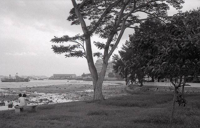
A part of Singapore we can never go back to. The view is of the waterfront and the Inner Roads from a vantage point just across the mouth of the Stamford Canal from Esplanade or Queen Elizabeth Walk. Land reclamation has since taken this view away, replacing it with a view that will include One Raffles Link and Esplanade Theatres by the Bay (David Ayres on Flickr).

Mr. Ayres interactions in Singapore came from his two stints at HMS Terror (now Sembawang Camp) in the Naval Base. The first in 1963/64, just about the time I was born, and again in 1966/67. Now 71, he finally managed a trip that he said he he just had to make having not been back to Singapore since he last saw it almost 50 years ago at the end of his second stint in 1967.

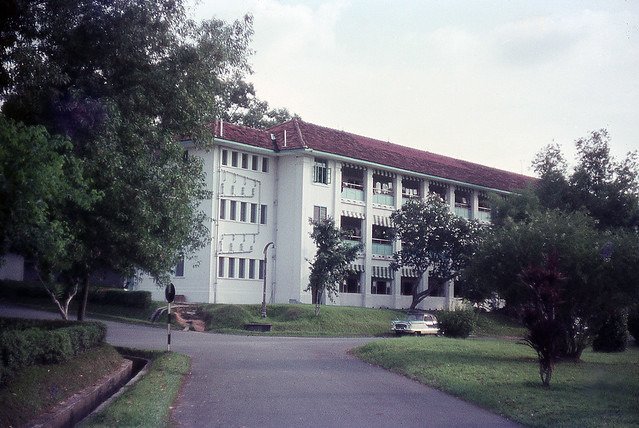
A HMS Terror (now Sembawang Camp) barrack block, one that is familiar to me as it was the same block I was accommodated during my reservist in-camp training stints in the 1990s (David Ayres on Flickr).

I managed to say a quick hello to Mr. Ayres during his short visit, managing a short chat with him at a coffee shop in what had once been Sembawang Village, an area that is quite well represented in Mr. Ayres’ set of photographs.  Once a busy area of watering holes, shops and makeshift eating stalls located just across one of the main entrances to the huge Naval Base – an entrance used especially by personnel headed to HMS Terror,  all that it has since been reduced to is the row of two-storey shophouses in which the coffee shop was at.

David Ayres (R), with Phil and Nora, the founder of Old Sembawang Naval Base Facebook group.

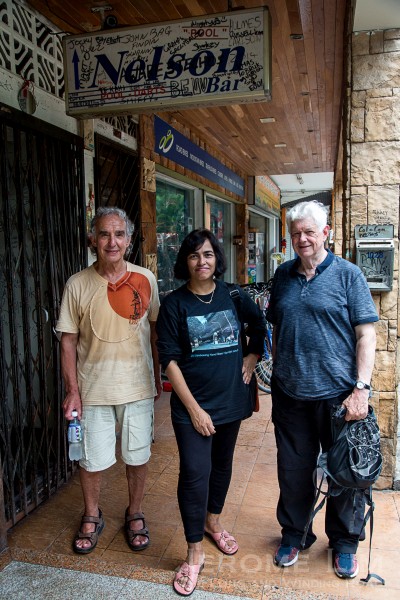
David Ayres (R), with his mate Phil and Nora, the founder of Old Sembawang Naval Base Facebook group, in the shadow of the Nelson Bar of today.

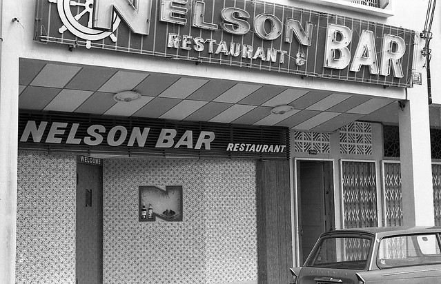
The Nelson Bar as seen in 1967 (David Ayres on Flickr).

It was interesting to learn that there was much Mr. Ayres could still recognise from his walk earlier in the day around the former Naval Base, a walk he did with his mate Phil with the help of Nora of the Old Sembawang Naval Base Facebook group. It is perhaps fortunate for Mr. Ayres that Sembawang, a part of Singapore he would have been most familiar with, is one of few places left in Singapore in which much of its past is still to be found in the present.

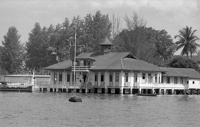
The Red House, as the Fleet Sailing Centre was referred to because of its red roof (David Ayres on Flickr).

The Red House today as seen from SAF Yacht Club. It's red roof tiles have since been replaced by green ones and the sea pavilion is now in a rather dilapidated state.

The Red House today as seen from SAF Yacht Club. It’s red roof tiles have since been replaced by green ones and the sea pavilion is now in a rather dilapidated state.

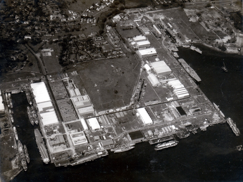
A good part of the base housing still remains intact, as do the former dockyard and stores basin, both of which still operating under another guise. Part of HMS Terror is also still around, a part that is visible over its perimeter fence. There also is the former “Aggie Westons” on the hill across from the dockyard gates. This saw use as the Fernleaf Centre in the days when the NZ Force SEA had troops based in Sembawang and is now in use by HomeTeam NS as a recreation centre. A sea pavilion, which served as the Fleet Sailing Centre in the days of the Naval Base, is also still visible from the SAF Yacht Club. Referred to as the “Red House” for its red roof tiles, the pavilion has since been turned green and as observed by Mr. Ayres, now looks rather dilapidated.

‘Aggie Westons’ in David’s time in Sembawang, it became Fernleaf Centre during the days of the New Zealand Force SEA and is today used by HomeTeam NS as a recreation centre. David made a stop here during his recent visit to Sembawang (David Ayres on Flickr).

As we pored over some photographs Mr. Ayres had printed over glasses of lime juice, he also made mention that the row of shophouses we were at had not been around during his first stint at HMS Terror. One of the area’s last additions, it had been put up before Mr. Ayres came back for his second tour. It is in the row that several bars including the Nelson Bar were housed and was a popular drinking spot for servicemen up to the days when the New Zealand forces had a presence in the area. It is also worth mentioning that the cluster of stalls found in the area, popular as stopover for personnel looking for a quick bite, was where the improvised hawker dish we know as Roti John is said to have originated from.

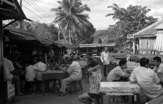
The cluster of food stalls at Sembawang Village, where Roti John was said to have been invented (David Ayres on Flickr).

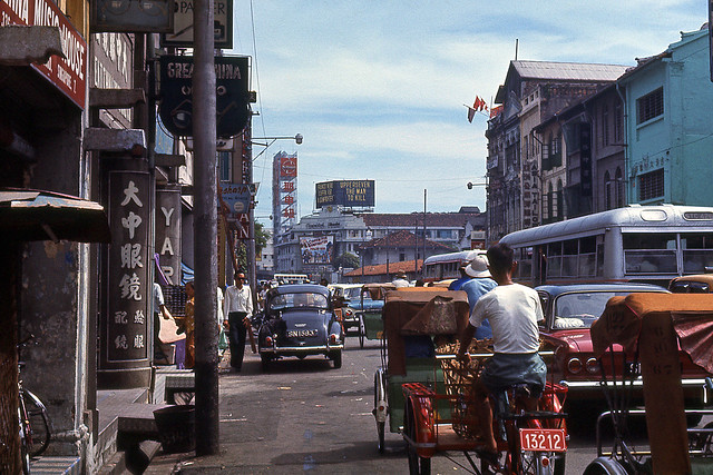
Besides those in and around the Naval Base, Mr. Ayres captures include many other places that featured in my younger days; places in and around the city centre, then referred to as Singapore, as well as a few far flung places such as Changi. There are also scenes found in the set taken in peninsula Malaysia that are familiar to me from the drives my father was fond of making north of the Causeway. The photographs of the city centre have proved to be particularly fascinating to younger Singaporeans. One taken of Raffles Place in its landscape car-park rooftop garden days  in the direction of Battery Road, made its rounds in 2012, going viral in Singapore. One impression of the modern city that had replaced the one in his photographs that Mr. Ayres and his friend Phil had, was of seeing very few elderly people in it; this perhaps is a manifestation of the disconnect with the brave new world that the city centre has become many in the older generation feel.

IMG_5830

Mr. Ayres’ capture of Raffles Place in 1966 made its rounds around the internet in 2012 (David Ayres on Flickr).

Mr Ayres’ photographs have a quality that goes beyond simple snapshots. Well composed and often offering a wider view of the places he found himself in, they not only take us back to the places we once knew but also immerse us into the scene being captured. The photographs are for me, a means to travel back in time, back to the places I could otherwise have little hope of seeing again, and back to a world I would not otherwise have been able to go home to.

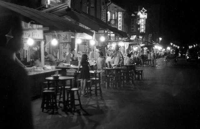
A street that once came alive in the evenings with its food offerings – the section of Albert Street at its Selegie Road end where Albert Court Hotel is today (David Ayres on Flickr).

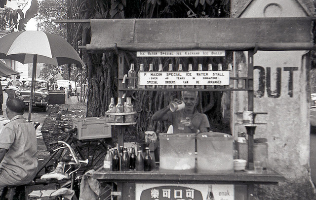
An “Ice Water Stall” outside what is today the National Museum (David Ayres on Flickr).

The gate post and the Indian Rubber tree today. The tree has since gained the status of a protected tree, having been listed as one of Singapore’s 256 Heritage Trees.

JeromeLim-0236

Changi Creek, 1966 (David Ayres on Flickr).

Changi Creek today.

Changi Creek today.

A familiar scene along Canberra Road that Mr. Ayres captured in 1966. The convoy of dockyard (and later Sembawang Shipyard) workers rushing home was seen into the 1980s (David Ayres on Flickr).

Jalan Sendudok in Sembawang. Notice that the Chinese characters used for Sembawang differ from those used today. The road, which still exists, has since been realigned (David Ayres on Flickr).

Where Selegie met Serangoon over the Rochor Canal, 1966. This photograph helps take me back to visits to Tekka market, the roof of which can be seen on the left of the photo, with my mother whenever mutton curry was on the menu (David Ayres on Flickr).

The same area today, Sans the open canal and and unfamiliar buildings, it now looks completely different.

The same area today, Sans the open canal and and now unfamiliar buildings, it looks a completely different place.

1966. The North Bridge Road that I knew, close to its junction with Bras Basah Road, close to where Jubilee and Odeon Theatres were, which would have been behind the photographer (David Ayres on Flickr).

The same area today.

The same area today.

Further down North Bridge Road in 1966 – a back entrance to Raffles Institution is seen on the left and the walls of the former Convent of the Holy Infant Jesus (now CHIJMES) can be seen on the other side of the road (David Ayres on Flickr).

The same area today.

The same area today.

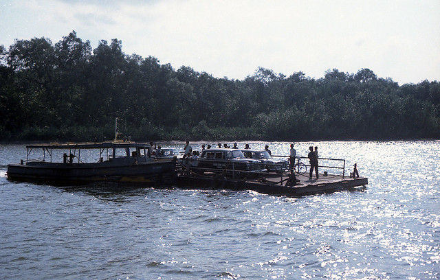
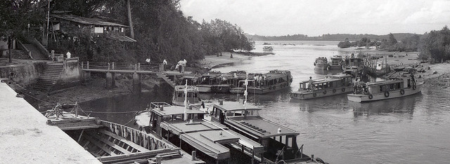
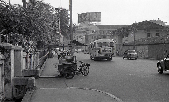
A river crossing in Malaysia in 1967. Not in Singapore but many from Singapore who travelled up north by road would have had this experience before road bridges across the major rivers were completed. One such crossing was at Muar. This existed up to the 1960s. My own experience was of two crossings on the road up to Kuantan in the 1970s and early 1980s. One had been at Endau, at which a tow boat similar to what is seen here was used. The other was a narrower crossing at Rompin that utilised a ferry pulled by wire-rope (David Ayres on Flickr).


The magazine under Talbot’s Hill

7 02 2015

An area of Singapore that still has much history buried under it is the area where the former British Naval Base was. Under parts of the former base, which covered an area stretching from the Causeway in Woodlands to what is today Sembawang Park, lies several underground structures, one of which is a the so-called Attap Valley bunker that has recently been brought to light.

The entrance to the Attap Valley bunker.

The entrance to the Attap Valley bunker below Talbot’s Hill.

Worshipping a new religion? Participants on a heritage tour to the site examining part of a ventilation system.

Worshipping a new religion? Participants on a heritage tour to the site examining part of a ventilation system.

The bunker, opened to the public for the first time today, is the last surviving structure of an armament depot constructed by the British within the huge Naval Base in the Talbot’s Hill and Attap Valley area. A ammunition and armament storage magazine, specifically Magazine No. 4, it was one of seven other bomb-proof magazines that were built into Talbot’s Hill by the British before 1942.

An extract of a 1945 map of the Naval Base showing the area and the layout of the ammunition depot, including the seven magazines under Talbot's Hill.

An extract of a 1945 map of the Naval Base showing the area and the layout of the ammunition depot, including the seven magazines under Talbot’s Hill (click to enlarge).

The National Heritage Board (NHB), which has been studying the site since April 2014, has also established with the help of a 1945 map of the Naval Base, that the magazines were part of a network of eighteen bunkers, warehouses and workshops spread over the Attap Valley site, that formed the Royal Naval Armament Depot.

The tour group being led into the bunker.

The tour group being led into the bunker.

The passage to the storage area.

The passage to the storage area.

Evidence points to the magazine, which is the size of two 5-room HDB flats, being used by the Japanese during the occupation – a cache of Japanese weapons and ammunition was found by MINDEF when they used the site for the Sembawang Ammunition Depot.

The storage area where  corrugated ceiling reinforcements can be seen along with a gantry hoist.

The storage area where corrugated ceiling reinforcements can be seen along with a gantry hoist.

What appears to be a light fitting from the time of the bunker's construction.

What appears to be a light fitting from the time of the bunker’s construction mounted on the ceiling.

According to NHB, part of the floor of the bunker, now a mess of mud and water, would have had rail tracks running over them to allow the ammunition to be moved in and out, accounting for the rusty colour of the mud and water in the bunker. While there is nothing left of the tracks to be found, there are several fixtures and fittings that might have originally been there at the time of its completion. This includes vents from an all important ventilation system, light fixtures, and pipes. A travelling gantry hoist, complete with a sign giving its Safe Working Load rating, can be seen in the inner chamber where the ammunition would have been stored. Access into the inner chamber is via a curved passageway designed so as explosions could be contained.

JeromeLim-8223

Talbot’s Hill and the surviving magazine under it now lies well within a fenced up area of land, which was returned to the State by  MINDEF when the depot was decommissioned in 2002. Access to it is only via the NHB tours, being organised as part of a Battle of Singapore commemoration that coincides with the 73 anniversary of the Fall of Singapore and also the 70 anniversary of the liberation in September 1945. More information on this, including the Case Files from the Singapore War Crimes Tribunal Exhibition scheduled to open next week at the National Museum of Singapore, can be found at the NHB website.

More photographs of the bunker and its surroundings

JeromeLim-8277

JeromeLim-8290

JeromeLim-8181

JeromeLim-8228

JeromeLim-8244

JeromeLim-8257

JeromeLim-8263

JeromeLim-8247

JeromeLim-8272


Postscript
An account relating to the last days of the Royal Naval Armament Depot before the Fall of Singapore: A Singapore Story – 1942.


Windows into Singapore: A world we soon may forget

12 02 2014

A view from a block of new housing over to colonial bungalows that had once served as the somewhat grand residences of the senior officers of the British Admiralty stationed at the Naval Base in the north of Singapore. The base, which stretched from the old Seletar Road (which was renamed Sembawang Road in 1939) to where the causeway is, occupied some 2,300 acres or 930 ha. of land along the northern coastline. As was a feature of the British military bases set up in Singapore, generously sized bungalows as well as flats were built to serve as residences for the senior military personnel.

JeromeLim 277A0045

The rolling hills of the area around which the bulk of the housing was built, on the eastern fringes of the base, did provide a wonderful setting that was close to the sea for the residences to be built on. Well spaced apart around the area, the former residences are set in the openness of lush green yards that would even then have been a luxury only the more fortunate would have been able to enjoy. The spacious and airy bungalows of the senior Admiralty, many of which are still around today, are particularly impressive, built in a style typical of the purpose – many were of single storey design and set on on a stilted foundation to allow added ventilation in the oppressive heat of the tropics, as well as to keep snakes and termites out.

The beautiful setting in which the 'black and white houses' of Sembawang find themselves in.

The beautiful setting in which the ‘black and white houses’ of Sembawang find themselves in.

These ‘black and white houses’ a term we in Singapore commonly use to refer to these bungalows due to their appearance (thought to be influenced by the Tudor revival movement that coincided with the first appearances of such bungalows in Singapore), are similar to those found other several areas in Singapore associated with former military bases. This includes the former RAF Seletar (Seletar Airbase) where 32 such bungalows are now slated for conservation at  (see: Straits Times report dated 11 Feb 2014).

Some 400 former residences including low-rise flats in the area were handed over to Singapore in 1971 when the British pulled their forces out. Many saw use by the ANZUK forces and later the New Zealand ForceSEA, with some currently used by the US Navy to house personnel based at the Commander, Logistics Group Western Pacific (COMLOG WESTPAC) and the Navy Region Center Singapore (NRCS) at the former Naval Stores Basin. Several units are also being rented out by the Singapore Land Authority (SLA).

The houses and the undulating and green landscape, provides the area not just with much of its laid back and somewhat old world charm, but also a feeling of space that is lacking in other parts of built-up Singapore. There is also that window the housing units, many of which came up during the construction the naval base in the 1930s, does also provide into a significant part of a past we might otherwise all too quickly forget.


More on the Naval Base 

A look at a ‘Black and White House’


Rooms with more than a view

28 07 2013

Tucked away on a hill some 38 metres above street level is a disused building that has gained a reputation for all the wrong reasons. Better known to most for what it has most recently been used for – the View Road Hospital, it has an uncertain beginning and was in the last days of the Naval Base, a barracks to house Asians in service with the Naval Base Police.

IMG_9915

The Naval Base Police, established at the completion of the Naval Base in 1938/39, was disbanded when the British forces pulled out in 1971. It counted in its ranks a large contingent of Sikh policemen, and later Pakistanis and Malays. A Sikh temple, the Gurdwara Sabha Naval Police has been closely associated with the force and from the time the barracks was established at View Road in 1959-60 until 1971-72, that was located right next to the barracks. The temple merged with another temple the Gurdwara Sahib Guru Khalsa Sabha Sembawang (Sembawang Sikh Temple) with the disbandment of the Naval Base Police in 1971. The Sembawang Sikh Temple in turn merged with the Gudwara Sahib Jalan Kayu as the Gurdwara Sahib Yishun and is now located at Yishun.

A July 1941 photograph showing Rimau Offices and Accommodation in the early stages of construction (National Archives UK via National Archives of Singapore online).

The Gurdwara at View Road Barracks, 1971

The gurdwara, at its closing in October 1971 (photo courtesy of Sheila Singh Sidhu).

The former View Road Hospital’s building goes a little further back. It would seem that it may have been completed in late 1941 (a 1944 map of the Naval Base – based on information developed prior to the outbreak of war – has it identified as the uncompleted “Rimau Offices”). A photograph dated 21 July 1941 from the National Archives UK shows in the very early stages of construction and another showing it almost complete in 1941. A photograph of an above-ground bomb-proof office on the site – above-ground possibly because it was built in a hurry, shows it in the late stages of completion in July 1941. Also an updated map of the Naval Base printed in 1945 shows the building completed.

img0077

Rimau Offices nearing completion in 1941 (National Archives UK via National Archives of Singapore online).

img0360

Rimau Bomb-Proof Office nearing completion in July 1941 (National Archives UK via National Archives of Singapore online).

BATU RIMAU DEC 1944 Intel Report

AA gun positions and buildings around the Bukit Rimau area, including Rimau Offices from a 1944 intelligence report.

From a 1968 edition of the map of the Naval Base, we see that it was the Naval Base Police Asian Quarters with the words “Old Maritime HQ” in parenthesis – indicating that it was built for either the RAF or the Fleet Air Arm of the Royal Navy for use it as a command centre for maritime air operations (hence the observation tower found on the building and also the “bomb-proof office” next to it). An RAF proposal to use it as such fell through in the 1950s due to signal interference at from nearby SUARA Wireless Transmitting Station. It would have only been around 1960, possibly the late 1950s, that the building was converted into a much needed barracks for Asian Naval Police personnel, many of whom had taken to renting accommodation outside the base due to shortage of quarters.

1944 War Office drawn Naval Base Map based on pre-war information.

Aug 1945 Naval Base Map showing building in place.

Following the pullout of the British forces, the building was converted for use as an secondary hospital to supplement the overcrowded Woodbridge Hospital, providing rehabilitation for recovering mental patients, particularly those with chronic schizophrenia. The first batch of 34 patients were moved into the 250 bed hopsital in September 1975. The rehabilitation  programme included providing skills training to the patients to allow the patients to return to society. A large group of about 100 would in fact be permitted to work outside the hospital, which was already running a laundry, a nursery and a cafe, in the day. The hospital was shut in 2001. The building has seen use as the View Road Lodge – a foreign workers’ dormitory – which was in use until a few years back. The building today lies unoccupied.

IMG_2006

A visit to the observation tower.

View Road Lodge in January 2011.

As the View Road Lodge in January 2011.

IMG_5359

The Bomb-Proof Office seen in Oct 2017.


The largest dock east of the Suez in the midst of a world that is to change

25 12 2012

Tucked in the far north of the island of Singapore is a huge 86 hectare shipyard which seems far out of place. Its location is far from the large concentration of shipyards and related industries which has grown in the far west of Singapore. The shipyard, Sembawang Shipyard, today stands as a physical reminder of a legacy left by the former colonial masters of Singapore. The British operated the yard as a Naval Dockyard which was an important component of a huge naval base which had stretched some six and a half kilometres along the northern coast from Woodlands (close to where the Causeway is) to Sembawang (the eastern boundary ran along the northern end of Sembawang Road from its junction with Canberra Road to where Sembawang Park is today).

An aerial view of the Naval Dockyard in 1962 (Image: Horatio J. Kookaburra on Flickr). The former Stores Basin can be seen on the lower left of the photo and the King George VI dock can be seen close to the top right. Three floating docks are today tied up along a finger pier constructed off the 850 metre northwall. The northwall is seen running along the lower edge of the photo.

An aerial view of the Naval Dockyard in 1962 (Image: Horatio J. Kookaburra on Flickr). The former Stores Basin can be seen on the lower left of the photo and the King George VI dock can be seen close to the top right. Three floating docks are today tied up along a finger pier constructed off the 850 metre northwall. The northwall is seen running along the lower edge of the photo.

The dockyard and the base was for a long time, an important source of employment in Singapore. A report in 1961 put the local workforce of the dockyard at 10,700, with the base accounting for as much as 20% of the Gross Domestic Product (GDP) of Singapore. What this did mean was that when the accelerated pullout of the British forces was announced in 1968, there were huge concerns, not only from a security viewpoint, but also on unemployment. As part of the arrangements made in the lead-up to the pullout, the dockyard was transferred to the Singapore government for a token $1 in 1968. Sembawang Shipyard Pte. Ltd. was established on 19th of June that year and a British commercial shipyard, Swan Hunter roped in to manage the transition of the yard to a commercial one.

The Dockyard's gates seen in the 1960s (source: www.singas.co.uk).

The Dockyard’s gates seen in the 1960s (source: http://www.singas.co.uk). The Naval Dockyard had been a major source of employment in Singapore. The local workforce in 1961 numbered some 10,700.

A key component of the transition was in training the local workforce, not just on the ground but also management staff to eventually take-over the running of the yard. Besides Swan Hunter, the British Ministry of Defence also seconded some 150 Naval Officers and civilians in the first year to ensure that the transition from a naval dockyard to a commercial one, over the three years it was to take the pullout to be completed, would go smoothly. The arrival of the first commercial ship came in March 1969 and by the time the year had ended, Sembawang Shipyard had docked some 66 merchant vessels and was well on its way to becoming a leading ship repair yard. The success of the shipyard was one of Singapore’s early success stories and by 1978, the tenth anniversary of the yard, a mainly local management team was in place to run the yard. The yard also introduced a highly successful apprenticeship programme in 1972 – from which many of the skilled labour and second generation supervisory staff were to come from and was key in not just raising skills levels, but also in improving productivity of the local workforce necessary to become competitive in the ship repair market.

The view of the northern area of the shipyard from the jetty at Beaulieu House. The three floating docks can be seen on either side of a finger pier off the northwall: KFD Dock on the outside on the extreme right; President Dock on the inside (with the ship on which the funnel is seen); and Republic Dock to the left of President Dock.

The view of the northern area of the shipyard from the jetty at Beaulieu House. The three floating docks can be seen on either side of a finger pier off the northwall: KFD Dock on the outside on the extreme right; President Dock on the inside (with the ship on which the funnel is seen); and Republic Dock to the left of President Dock.

The yard as we see today, has seen a huge expansion in its capacity with the addition of many facilities since it inherited the already well equipped dockyard in 1968. In addition to the King George VI graving dock (referred to affectionately as ‘KG6’), which when it was completed in 1938 was described as the largest graving dock east of the Suez (and the largest naval graving dock in the world – more on it can be found in a previous post on the Naval Base), the yard now has a huge 400,000 DWT capacity graving dock – Premier Dock built next to KG6, as well as three large floating docks. Premier Dock was an early addition to the yard, having been completed in 1975 at a cost of $50 million and opened by the then Prime Minister Lee Kuan Yew. Plans for the huge dock which measures some 384 metres in length and is 64 metres wide, built to meet a demand for the repair of huge Very Large Crude Carriers (VLCC) which were being constructed, were drawn up as early as in 1968, although the go-ahead was only given in 1972. The 150,000 DWT President Floating Dock which was one of the largest floating docks in Asia at the time was added in 1981.

A photograph of KG6 with the Queen Mary docked in it in August 1940 (source: Australian War Memorial  - 'Copyright expired - public domain').

A photograph of KG6 with the Queen Mary docked in it in August 1940 (source: Australian War Memorial – ‘Copyright expired – public domain’).

The sheer size of yard can probably only be fully appreciated attempting to walk from its entrance at Admiralty Road West to the far end of it located just west of the former Stores Basin of the Naval Base (now used by the US Navy as a logistics base) – an end which is visible from the old jetty at Beaulieu House. It does take a good half an hour to 45 minutes to do just that – an effort that I regularly had to make to get to Berths 8 and 9 of the yard during the six long months I spent undergoing training at the yard in 1983/1984 (so much so that many of us ended up bringing our own bicycles to reduce the effort). That six months is probably one that was for me best forgotten – the slump in demand for ship repair then meant many hours spent squatting in a designated area when there was no work assigned to the work gangs we were attached to. Tea-time was always a time to look forward to then – it provided that much needed break in monotony. As trainees, one of the tasks assigned was to head to kiosks located at strategic locations along the wharf sides to buy pre-packed packets of tea and coffee as well as snacks for the rest of the gang.

HMS Bulwark off the northwall of the Naval Base in the 1960s - the northwall is where the far end of the shipyard is today.

HMS Bulwark off the northwall of the Naval Base in the 1960s – the northwall is where the far end of the shipyard is today (source: http://www.acig.org/artman/publish/article_203.shtml).

The yard, besides being the location of a historically significant graving dock, is also where a conserved building in the form of the former Sembawang Fire Station can be found in. While it does look like the yard is a long time fixture in the area and so the future of this historical part of Sembawang is quite safe, we do know that the winds of change is right now sweeping across large parts of the area close by. The expansion of Yishun town and Sembawang town will bring high-rise developments that will do much to alter a unique character and charm that has been associated with the area since the days of the Naval Base. The area to the east of the yard is itself undergoing a tremendous change. A renewal programme will see the park feel a lot less like the quiet corner many like me had found an escape in, and more like any other overly manicured seaside spot in Singapore. That does I suppose does complement the private development just to its east. That development will see a shoreline where idyllic seaside kampungs could once be enjoyed and a shoreline I have continued to find an escape in, become a place in which that charm will no longer be found.

What will be one of the last escapes from the overly manicured world we now find ourselves in.

The shoreline along the former Kampong Wak Hassan is one of the last escapes from the overly manicured world we now find ourselves in we will soon lose.


Last post standing

16 07 2012

Standing somewhat forgotten and hidden under the roots of a tree is a marker of what used to be the perimeter of what had once been described as the largest naval base east of the Suez – the Royal Navy base at Sembawang that extended for some six and a half kilometres as the crow flies from Woodlands (close to the Causeway) to Sembawang (where Sembawang Park is today). The marker, a gate post belonging to the former Rotherham Gate, the northernmost gate into the former base, is the last remnant of several entrances into the huge naval facility that had once been the pride of the British Empire and a significant source of employment for residents of Singapore.

Rotherham Gate in the 1960s (source: Derek Tait).

The gate located at the western edge of the Naval Base and one of the main entrances into the base (the others being Sembawang Gate and Canberra Gate to the east and the southeast) was renamed as the Rotherham Gate in 1945 in commemoration of the role of the Commander of the RN Destroyer HMS Rotherham in the acceptance of the surrender of men from the Japanese Imperial Navy at the Naval Base in September 1945. Along with the other gates, the gate was manned by security personnel deployed by the Royal Navy stationed at the guard-houses that had once stood by the entrances, right until the end of October 1971 when British Forces formally withdrew from Singapore. Remnants of some of the gates in the form of gate posts and guard posts had in fact stood for some time after including that of the Rotherham Gate. Based on an account by a former resident of the base, Mr Kamal Abu Serah, the guard-house that had stood inside the gate had actually housed a provision shop after the opening up of the Naval Base in 1971.

The area where the Rotherham Gate once stood. The last post standing is now gripped tightly by a tree which has taken root on the post.

Hidden behind the roots of a tree and parasitic plants which have also taken root on the tree is the last post standing … close examination reveals a rectangular concrete column beneath the tree’s roots.

The gate post today, serves as a marker of the western end of what is the recent redeveloped Woodlands Waterfront , an area that for a long while had been left behind by the pace of redevelopment that has swept through much of the rest of Singapore. The area had after the opening up of the Naval Base, long been a haunt for anglers and was in fact one of the places that I frequented in the 1970s for fishing and to catch crabs. A derelict jetty which was missing most of its deck planks had been one of two jetties that my father sometimes took me to. The jetty, the old Ruthenia Oiling jetty (which my father had referred to as the Naval Base jetty) has since been demolished. It was one of several jetties that jutted out of the coastline in the area, the only one that was accessible to the public in the 1970s and became quite a popular spot for crab fishing before it was demolished. The other jetties were the Customs Jetty, the Shell Jetty (Woodlands Jetty), and the large L-shaped jetty that was used by the Royal Malaysian Navy – the Tentera Laut Diraja Malaysia (TLDM).

Parts of a 1968 map showing the location of the Rotherham Gate, the perimeter fencing and the position of the four jetties in the area (source: Ms Nora Abdul Rahman).

The TLDM had maintained not just a large jetty in the area – Woodlands had in fact hosted the main base of the TLDM, KD Malaya, up until 1979, the base having first been established in 1949 with the setting up of the Malayan Naval Forces (MNF). The TLDM continued to operate KD Malaya as a training facility even after the shift of the main naval base to Lumut up until December 1997 together with the jetty. The jetty has since been incorporated as part of the Woodlands Waterfront redevelopment and is now opened to the public. Both the jetty and the former TLDM barracks, which can be seen along Admiralty Road West, remain as a reminder of the Malaysian navy’s long-standing presence in what was an independent Singapore.

Part of the former TLDM jetty, now opened to the public, seen at dusk.

The view across the straits to Malaysia … Malaysia operated a Naval Base across the straits in Singapore up until 1997.

In between the Shell Jetty and the former TLDM Jetty is where a river, Sungei Cina, spills into the sea. Sungei Cina, for most part, still has its natural banks. The vegetation that one finds along its banks is probably representative of the vegetation which would have been found along much of the swampy shoreline that had existed before extensive reclamation work during part of the ten years it took to construct the base in between 1928 to 1938 – construction which saw substantial parts of the coastal swampland filled with earth – some of which came from excavation work around where the Naval Dockyard was being constructed to the east of the Naval Base. A large part of the land on which the Naval Base had been built was that which had acquired by the Straits Settlements from belonged to the Bukit Sembawang rubber estate and given to the Royal Navy for its use. The huge excavations around the area of the Naval Dockyard was not just to provide a dockyard that since 1968 has been used by Sembawang Shipyard, it also provided the largest naval graving (dry) dock in the world when it was opened in February 1938 – the King George VI dock (known also as ‘KG6’) which is still one of the largest dry docks in South East Asia.

A swamp once extended along the shoreline of what is now the well manicured Woodlands Waterfront – a waterfront that even before its redevelopment has attracted many anglers to the area. The Senoko Power Station and the Shell Jetty can be seen at the far end of the shoreline.

Vegetation along the banks of Sungei Cina is probably representative of the vegetation found along the coastline before the Naval Base was constructed.

Speaking of the graving dock, it has been reported that a ‘keramat tree’ was said to have been responsible for a delay in its completion, as a consequence, the completion of Naval Base. The ‘keramat tree’ had been a lone tree standing (after the rubber trees around it had already been cleared) on a hill which needed to be leveled to allow the graving dock to be constructed. The coolies assigned to cut the tree, which was thought to have stood where the top of the graving dock now is, could not be persuaded to do so, believing the tree to be occupied by evil spirits. An anonymous letter was said to have mysteriously appeared carrying a warning that if a certain sum of money was not paid to allow gifts to be offered to appease the spirits, three heads of the firm involved would die. The warning wasn’t heeded and the tree eventually blown up and an increase in malaria cases followed which was put down to the act. That wasn’t all, as was predicted, three untimely deaths did follow – that of an agent for the contractors, the managing director and a sub-agent.

A photograph of KG6 with the Queen Mary docked in it in August 1940 (source: Australian War Memorial – ‘Copyright expired – public domain’). The construction of the dock had been delayed by the refusal of coolies to remove what was referred to as the ‘keramat tree’.

The tree that has taken root on the last gate post does perhaps serve to remind us of the tree that had had resisted the base’s construction. It does however serve, more importantly, to remind us of more than that, preserving within the tight grasp of it roots a memory of the wider area’s association with a huge and strategic naval facility. The facility was one that, large enough to accommodate half of the British Empire’s fleet, provided jobs to one in ten in Singapore accounting for one-fifth of its GDP at the time and one that should not be forgotten.