The photographs of the remains of Connaught Battery contained in this post were taken during a recent recce accompanied by a member of Sentosa’s staff. Do note that the area in which the remains are found is out of bounds. It contains a number of hazards and it is not only not advisable not to visit the area without the necessary permissions and supervision, you would also be trespassing if you do so.
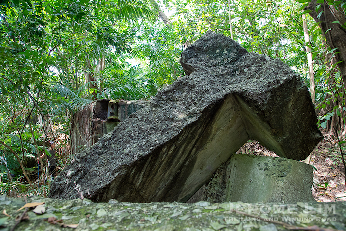
The remains of Connaught’s No 3 Gun emplacement.
Hidden in the vegetation of Sentosa’s two easternmost elevations just a stone’s throw away from one of Singapore most luxurious residential quarters, are the remains of its guns from the era of the Second World War. The better known of the two elevations, is of course Mount Serapong, which has been made accessible through public tours. A second set of guns, three 9.2 inch guns, were placed on the neighbouring elevation. These went into action during the Second World War, and were turned north and north-west to fire towards advancing Imperial Japanese Army troops in the direction of the Causeway, Jurong and Bukit Timah. All available ammunition, a large proportion of which were armour piercing and therefore ineffective against the advancing foot soldiers, was used before the guns were spiked and destroyed on 14 February 1942 — a day before Singapore capitulated. What remains of Connaught Battery include the badly damaged No 3 gun emplacement, a Battery Observation Post and an underground magazine, a retaining wall of the underground structure and several ventilation and other openings.
Another view of the No 3 Gun Emplacement (inside – the shaft and opening for the ammunition hoist can be seen)
A Battery Observation Post
Fittings for railings and a hinge on the emplacement
Inside the BOP
Inside an underground magazine (note the red brick cavity wall)
The cavity wall arrangement, which was possibly installed for moisture control
A view up the ammunition hoist
Background to the development of Sentosa’s Coastal Defence Positions and Connaught Battery
For large parts of its history, Sentosa was not as tranquil an island as its name would suggest. The so-called isle of tranquility, was previously called Blakang Mati, a name that carries with it a suggestion of death or even violence, even if little seems to be known about the origins of a name that it was known by since at least the early 17th century.1 Blakang Mati was also an island that has long had a reputation of being a pirates’ lair. This seemed to be the case as far as the 14th century, with the accounts of Yuan dynasty Chinese voyager, Wang Dayuan, describing what is now thought to be the waters in the area of the island as being infested with pirates2.
While an air of tranquility may have descended on the island following the Honourable East India Company’s (EIC) entry into Singapore with its second Resident, Dr John Crawfurd, describing it as a “beautiful and romantic spot”3, the spectre of death seem to still hang over Blakang Mati. Outbreaks of “Blakang Mati Fever” occurred. These were “of so deadly a character as to carry off three quarters of those attacked”, prompting some of those who settled on the island to flee in “fear and horror”.
The threat posed by “Blakang Mati Fever” however, did little to stop the one square mile island from being turned into one of Singapore’s most heavily armed and fortified square miles. Suggestion were in fact made as early as 1843, for an infantry garrison to be placed on the island as part of a plan to defend Singapore. While little came out of this plan in relation to Blakang Mati, the threat posed by Imperial Russia through it establishing a base in 1872 at Vladivostok on land it acquired from China, and the fact that advances in naval shipbuilding had greatly improved the speed, range, armour, and armament carrying capability of warships, prompted the building up of a coastal defence system to protect the Singapore and New Harbour. Measures taken included the placement of coastal artillery batteries on Blakang Mati. By 1878-79, batteries with fortifications were established at Fort Blakang Mati East (renamed Fort Connaught in 1890 to commemorate the visit of the Duke of Connaught to Singapore) and Fort Siloso. This effort also saw an infantry redoubt built at Mount Serapong.
Blakang Mati’s coastal defence positions and armaments on Sentosa would see overhauls over the years. Among the upgrades was the setting up of a battery at Mount Serapong following a review undertaken in 1885 with Singapore’s growing importance as a coaling station ii mind. Another upgrade, made from 1907 to 1911, came in the wake of Japanese successes in the Russo-Japanese War. This saw the battery at Mount Imbiah added, which was completed in 1912 with Fort Connaught’s battery being decommissioned as a result of it. Imbiah Battery would itself be decommissioned in 1937, when a rebuilt Connaught Battery came into play. The battery, along with a battery at Mount Serapong, remained in service up to the time of the Second World War. The rebuilding of Connaught Battery resulted in the removal of all traces of the 19th century fortifications of Fort Connaught.
While the guns at Serapong seemed to have been damaged during Japanese air raids in January 1942, the three guns at Connaught Battery were turned northwards and were fired in the direction of the Causeway and later at advancing Japanese troops at Jurong on 11 Feb 1942 and Bukit Timah on 12 Feb 1942, expanding all the available ammunition, before being spiked and destroyed on 14 Feb 1942.
________________
1 The first instance of the island being positively identified as Blakang Mati was through a map made by the Malacca-based Manual Godinho de Erédia. This was published in 1604 to aid in the discovery of the legendary islands of gold. In the map, the island is identified as “Blacan Mati” with the “c” being pronounced as a hard c.
2 In Wang Dayuan’s accounts contained Daoyi zhilüe (島夷誌略) or “Description of Barbarians of the Islands”, he provides a description of a pirate infested “Longyamen” (龍牙門) or Dragon-Teeth Gate, which is now believed to have been a reference to the pair of rocky outcrops at Tanjong Rimau at the western end of Blakang Mati and across the waters at Tanjong Berlayer. Known as “Lots Wife” to the British, they were removed to widen the entrance to New Harbour (Keppel Harbour) in 1848.
3 Among the early uses of the island in the early days of EIC Singapore was the installation of a flagstaff on the island’s highest peak, Mount Serapong, in 1833. The island would also find use for the cultivation of pineapple, jackfruit, guava and chempedak with three villages being established. One was Kampong Ayer Bendera, which was named after the flagstaff. This was located at the foot of Mount Serapong and inhabited primarily by Bugis. There was also a Malay village in the area known as Kampong Serapong, while the third village was Kampong Blakang Mati, another Bugis village. A few Chinese also found their way to the island.
Tanglin Village or Dempsey Hill, a spacious and joyous site on the fringes of Singapore’s city centre, has a history that goes back more than a hundred and fifty years. Established as Singapore’s first purpose-built military camp, Tanglin Barracks, it is a place with stories abound. There are quite a few that I find especially intriguing, including one which has as its leading protagonist a rather flamboyant German mariner by the name of Julius Lauterbach, whose exploits on and off the high seas make for quite an interestIng read.
Tanglin Village today
Lauterbach’s chapter in Tanglin’s history is set against the backdrop of the First World War, a conflict which pitted his native Germany against Singapore’s colonial master, Great Britain. Almost overnight, friends found themselves on opposing sides and even if the war may have been raging far from Singapore’s shores, its fallout extended to the island in one way or another. On 24 October 1914, some three months into the conflict, nationals of Germany and Austria in Singapore received an order to report to the P&O Wharf. There were a number of prominent members of the mercantile community amongst the group. Initially interned on St John’s Island, the group would be moved into Tanglin Barracks‘ vacant blocks and were joined by internees who had been detained in Malaya.
St. John’s Island.
The choice of Tanglin Barracks as a place of internment was only possible as the British infantry units who would have normally be quartered at the barracks were most — in Europe. This arrangement however, would leave Singapore with threadbare defences, although there seemed to be little of concern with the main threat to the island’s security having been ascertained as internal rather than external. The responsibility for maintaining order was placed squarely on the shoulders of the officers and men of a British Indian Army infantry regiment — the 5th Light Infantry, which was quartered at Alexandra Barracks.
The former Gillman Barrack’s officers’ mess – close to the site where the first shot was fired to signal the start of the mutiny.
At Tanglin Barracks, a total of about 250 civilians were held, accommodated in a cluster of barrack buildings which had been ‘wired in’ with scaffolding used as watch towers. The 5th Light Infantry provided the camp’s security details together with a handful of men from the volunteer units. Within the confines of the camp boundary was also a ‘small bungalow’ that was converted for use as a hospital for internees. Tanglin Barracks’ Teutonic flavour was also to be enhanced by a group of about sixty Prisoners of War (POWs) from the German naval cruiser, SMS Emden, which brought the total number of internees at the camp to 309. The POWs were housed separately within the confines of the camp in a barrack block that acquired the name ‘Emden Villa’.
The cricket field and P-Block.
The Emden must have been quite well known in Singapore, having gained notoriety for the damage and disruption to Allied shipping in the Indian Ocean and the China Sea that it had inflicted in the early months of the war. Among the cruiser’s exploits was a daring raid on Penang harbour during which two ships — a Russian cruiser and a French destroyer — were sunk. The Emden, as did many naval vessels on both sides, also employed tactics that could be compared to pirate ships in sending boarding parties to storm merchant ships, either to scuttle them, or if the cargo was valuable enough, to commandeer these vessels as a ‘prize’. The men of the Emden who had found their way to Tanglin were in fact members of ‘prize crews’ of three ships that were recaptured by the Allies, the most senior of whom was Reserve Lieutenant Julius Lauterbach. Lauterbach was taken along with the prize crew of the collier, Exford, which was carrying a cargo of 6000 tons of coal when it was recaptured by the armed auxiliary cruiser, HMS Empress of Japan, off Sumatra on 11 December 1914.
Lauterbach was already well known in many circles in Singapore in his days as a master mariner who was based at the port of Tsingtao (Qingdao), which Germany held as a concession port from 1898 to 1914. He had been an established fixture on the merchant marine scene and many among the civilian internees had made the passage on ships that Lauterbach had captained. His arrival at Tanglin was said to have been greeted with a loud cheer because of his fame. Being the highest ranking officer among the POWs, Lauterbach was afforded with a degree of respect by his captors, who put him in a three-room house on his own within the camp perimeter and close to the Emden Villa.
Julius Lauterbach at Tanglin
As soon as Leuterbach arrived in Tanglin, he set out plotting an escape and after having observed security arrangements at the camp, he determined that a tunnel would best serve his purpose. On 27 January 1915, with help from a group of trusted men he started on his dig right under the noses of the camp guards, under the guise of doing gardening. It could also have been that the members of 5th Light Infantry who were guarding the camp and who were free to interact with the internees, was under Lauterbach’s influence. Lauterbach was also able to have the company of a French-Chinese Eurasian admirer during his internment, albeit with a locked gate in between them. The young lady, according to a boast that Lauterbach made, had come to Singapore to see to his wellbeing having made her way from her native Shanghai once she got wind of his plight and was also able to hand information such as maps to him to aid in his intended escape.
A very special ward.
Mutiny
All this while, unhappiness was fermenting (some say fermented by Lauterbach and company) among members of the 5th Light Infantry. In January 1915, a decision was made to deploy the 5th to Hong Kong. The destination was however not communicated to the troops. There were rumours abound that the destination was not East, but West in Mesopotamia (modern day Iraq). With it large Muslim contingent, many among the rank and file were incensed by the prospect of having to fight fellow Muslims. In a move to quell the growing sense of unease, the transfer was brought forward. With the 5th due to be sent out on 16 February 1915 — the day after the three day Chinese New Year holiday weekend, the unit stood down from its duties at Tanglin on 14 February 1915 and camp security was left in the hands of one British and three native officers and twelve men of the Johore Military Forces, who were without ammunition, and a deployment of volunteers.
Remembering the victims of the Mutiny – a plaque at the Victoria Concert Hall.
The growing sense of unhappiness and the impending move to what was rumoured to be Mesopotamia provoked members of the 5th Light Infantry into action and just after 3 pm on the afternoon of 15 February 1915, members of the regiment’s Right Wing — numbering just over 400 men, mutinied (infantry regiments were then split into two wings, each with four companies). A group of about eighty rebels headed to Tanglin, intent on freeing German prisoners in the hope that they would lend support to the rebellion. At 3.45 pm, the mutineers reached Tanglin with a group among the eighty laying siege to Tanglin Military Hospital and firing into its administration building. In spite of coming under fire, Staff Sergeant Vickers, RAMC, managed to make his way to the medical officers bungalow some 300 yards away (270 metres). Finding the Medical Officer out, he was able to raise the alarm to the police, Fort Canning and a Dr Fowlie. A group of fifteen men reached the POW camp about half an hour later around 4.15 pm and also fired on the guards. The lock to the gate was then blown up. In the chaos of the attack, four officers were killed along with ten men. One German prisoner was also fatally wounded.
Buildings of the former Tanglin Military Hospital.
An eyewitness, Corporal J F Bray, RAMC, who was stationed at the prisoner hospital recalled being roused by the firing. German prisoners then told him that a mutiny had broken out. He then rushed to the POW hospital’s dispensary to get dressings in order to attend to the wounded, one of whom was a prisoner in W-Block (now Block 17). Inside W-Block, Bray witnessed six to seven members of the 5th freeing German prisoners before moving them into Y-Block (Block 26). Bray also witnessed the leader of the mutineers shaking hands with the German prisoners. Unsuccessful in their attempts to enlist the help of the Germans, the mutineers then left, promising to return with arms and ammunition. The bulk of the German prisoners, including Lauterbach, had in fact refused to take up arms; some went on to help in attending to the wounded, and transport the more seriously hurt to Tanglin Military Hospital.
Block 17 – a block that many who served National Service in the army will remember as the Enlistment Centre
Lauterbach’s Epic Escape
In the commotion of the disturbance at Tanglin, Lauterbach made a final push to finish the tunnel that he had been working on. Determined to get away unnoticed, he decided against walking out the open camp gate and use the tunnel he had worked on. Selecting a handful of prisoners to go with him for their ability to speak English made the escape as the darkness fell, having to making a vault over a final set of barbed-wire that lay beyond the tunnel exit. Leaving at around 8pm, the group decided that the main roads were to be avoided and took a route through grass, lallang and rubber plantation — a decision that got their guide and themselves lost. With some further help obtained through a handsome bribe, the group eventually found their way to the coast, some five hours after leaving Tanglin. There the scene was set for a voyage to Karimun. The long twelve hours that it would take them to get to the islands, which lay on the neutral Dutch side of the Melaka Strait, would only be the first leg of what was to become an epic journey of escape. The journey was to involve trudging through the jungles of Sumatra, a journey from Padang to Batavia (Jakarta) to Surabaya, a passage on a Dutch steamer to the Celebes (Sulawesi), a five day passage across the Celebes Sea to Mindanao in a leaking boat that required water to be bailed out by hand continuously, a voyage disguised as a Dutchman from Manila to China’s north coast where he made his way down to Shanghai. From Shanghai, he would head east to Japan, then Hawaii, and San Francisco from where he boarded a train for New York. At Hoboken — across the Hudson from Manhattan, Lauterbach signed on to a Oslo bound Danish ship as a Swedish stoke. Making landfall in Europe, he made his way to Copenhagen before finding himself on German soil on 10 October 1915 — some eight months after his escape from Singapore and ten months after his capture onboard the Exford.
Set in scenic surroundings in Singapore’s rustic north-eastern corner, the area we refer to as Changi Point, is one in which I have found great joy in. It is an area of much beauty with much of its natural geographical features intact and wears a charm that is little changed from the time I first interacted with it more than half a century ago. Over the years, I have also discovered that the area is one with quite a history; a history that is even recorded in maps of a 17th century battle off Changi. Also as fascinating is Changi Point and its more recent past, one that goes back to the early decades of Singapore as a British East India Company trading port.
Changi today – with a view towards Pulau Ubin
Remote and inhospitable and with its surroundings dominated by mangrove and terrestrial forests in British Singapore’s earliest years, Changi Point’s charm must have already been in evidence then; so much so that several adventurous souls amongst the gentry recognised its potential as a spot for a retreat. Among the first to see this was Mr Gottlieb, who put up Fairy Point bungalow on what could be thought of as the prime of prime locations on the seaward side of an elevation he christened Fairy Point Hill.
Fairy Point – the site of Mr Gottlieb’s Bungalow
In addition to Mr Gottlieb’s place of escape, the government had also had a bungalow built. Besides serving as a stay-over location for officers sent to the remote area for surveys, its use was extended for leisure purposes. By the mid-1840s, Changi Bungalow – as it had come to be known, had gained the reputation of being a “fashionable resort for picnic parties”. Constructed of wood, the bungalow had to be rebuilt several times over the years with its last iteration being demolished in 1965. The expansive grounds of the bungalow is an area that until today, has been in the hands of Singapore’s successive governments and amongst the structures now found on it is the 1950 built Changi Cottage, as well as several other holiday facilities.
Changi Cottage
One holiday home from Changi’s past that is still standing is a bungalow that belonged to Mr Ezekiel S Manasseh, who is often confused with Sir Manasseh Meyer. A founder of Goodwood Park Hotel, Mr E S Manasseh is better known for his mansion in Tanglin, Eden Hall, which is the British High Commissioner’s residence today. Mr Manasseh also maintained a holiday home in Changi Point. Located on the left bank of Changi Creek, he often extended its use to newlyweds for their honeymoon early in the 1900s. The bungalow stands today as the CSC Clubhouse.
Muslim graves at the foot of Batu Puteh Hill – a reminder perhaps of Kampong Batu Puteh.
Around this time (the early 1900s), a Japanese owned hotel also made an appearance along the beach just east of Fairy Point in the area of a Malay kampung named Kampong Batu Puteh. The wooden hotel, which was perched on stilts that extended across the foreshore, was rumoured to have offered more than a getaway and was rumoured to have been a place of ill repute. Whatever the hotel may have offered, time would soon be called on it with events on the world’s stage setting a new course for Changi Point.
While the Great War of 1914 to 1918 did not affect Singapore directly, its impact was and would be felt in many ways, not least through the fluctuations in the price of rubber through the war. There was also that episode of the insurrection that began at Alexandra Barracks during Chinese New Year in 1915 that was founded partly on a rumour being spread among the Sepoy Muslim mutineers that they were being sent to Mesopotamia to fight fellow Muslims. Among Britain’s allies who responded to calls for help were some 190 Japanese resident volunteers, and another force of 142 from two Japanese naval ships.
Memorial to the victims of the 1915 Mutiny at Victoria Concert Hall
The Imperial Japanese Navy had been on the rise for a number of decades. Having acquired knowhow to build its own naval hardware as well as in naval tactics from Britain and France, by the time the war started, the Japanese navy was in a good position to support its allies in the Entente. Japan actions in the naval arena would also however lay its ambitions bare, especially in regard to German held territory in China. The sense of discomfort in Britain grew in the post-war period with Japan having the third largest navy in the world after the United States and Britain. By 1921, a decision had been taken by Britain to protect its Far East interests through the construction of a huge naval base in Singapore.
A consequence of building the naval base in Singapore, and having it sited in Seletar – as the Sembawang area was also known as, was in the placement of coastal artillery around Changi to defend the base against naval attack. Changi, located at the eastern entrance to the Tebrau or Johor Strait, was hence, strategically sited at the entrance to the naval base. With the need to install, man, maintain and protect the guns, Changi was also developed as a military cantonment.
An extract from a 1935 map showing positions or intended positions of Defence Electric Lights at the eastern entrance to the Straits of Johor (including those at Pengerang) and their coverage (National Archives of Singapore online).
The first section of the cantonment was built at Changi Point. Work progressed in in a stop-start manner, first from 1927 to 1930 and again from 1933 to 1935, due to the evolving political situation in Britain. Being the first barracks on site and located in a prime location, this section became the home of Royal Engineers’ units as Kitchener Barracks. There would also be barracks constructed for the Royal Artillery at Roberts Barracks and for infantry units at Selarang Barracks. In addition to these, a few other camps were also established for the rank and file among the British Indian Army troops protecting the area.
Selarang Barracks Officers’ Mess
The huge investment in the base and in facilities at Changi and elsewhere across the island did little in terms of doing what it was meant to do and on 15 February 1942, the “impregnable fortress” that Singapore had been touted as, fell into the hands of Japanese forces – a mere two months after Japan launched its invasion of Malaya. Except for the feint assault on Pulau Ubin on the eve of the Imperial Japanese Army’s 8 February 1942 invasion of Singapore, and the firing of Changi’s huge coastal guns against advancing Japanese troops, Changi would see little in terms of military action in the lead up to this inglorious fall. Contrary to popular belief, the guns were used with at least one of the monster guns of the Johore Battery firing about eighty rounds before its rifling started to protrude. Although the guns were fired, they did little to stop the advance. The armour piercing rounds that they were supplied with in anticipation of a naval assault, were ineffective against ground forces. On 12 February 1942, with Japanese forces made rapid progress coming down the down and west, the order was given to units defending Changi to pull back to Singapore’s urban centre. The cantonment and its lightly damaged buildings were left empty, and Changi’s guns destroyed. It would be some days later, on 17 February 1942, that Changi would come into the spotlight.
The spiked No 2 Gun, one of three 15″ guns of the Johore Battery.
The Fall of Singapore left the Japanese invasion forces with quite a big headache. With tens of thousands of surrendering British and Australian led personnel from units that made the retreat down Malaya and troops defending Singapore, they were overwhelmed. There was the need to accommodate, secure and maintain the discipline among the Prisoners of War (POWs) and a solution provided by Changi and its abandoned cantonment. On 17 February 1942, some 50,000 prisoners-of-war or POWs, were made to march to Changi to occupy its various barracks and camps.
Barrack Hill in Kitchener Barracks – part of the POW camp for Southern Area forces from Feb 1942 to May 1943.
The former Kitchener Barracks was used to accommodate members of the Southern Area forces with some 15,000 Australian POWs occupying Selarang. The POW hospital was also to be centralised in Roberts Barracks on 26 February 1942, one of two sites – the other being Selarang – at which hospitals were established prior to the Fall of Singapore and immediately after the POWs were moved to Changi. It would be in the chapel at Roberts Hospital that the famous Changi Murals would be painted. The murals still exist today. Found in Block 151 in Changi Air Base West, they are quite unfortunately out of bounds to members of the public. In the early part of camp life, there had apparently been minimal contact with their captors, with prisoners being tasked with wiring themselves into the various barrack areas as well as taking care of their own discipline.
Block 151. Now in Changi Air Base West, this was one of the Roberts Barracks blocks that served as the POW Hospital from February 1942 until September 1943.
Life as a POW in Changi, and in Kitchener Barracks was tough for many reasons and not least through the lack of food and nutrition as well as the diseases that the POWs were exposed to due to conditions in captivity. Still, many found the strength to go on through the activities that were organised. Sports became a means to provide distractions to the routine of life as a POW – at least in the first year of captivity. Among the ranks were several professional sportsmen, including Johnny Sherwood, a footballer who played in the war time FA Cup final. The sports fields and facilities that the barracks in Changi had been provided with proved useful with cricket and football matches being played on them. Theatrical performances were also organised and college level courses. In Kitchener, classes of the Southern Area College were taught by academics, some of whom were from Raffles College. Several were members of volunteer units which had been placed under the Fortress Singapore command.
The Changi Padang – it was used for sporting activities during the first year of POW captivity.
In the many comparisons that were made by POWs at Changi, there is a consistent theme of how life may have been hard, but was in fact “heaven” compared to what many were to face elsewhere. Throughout the initial period of captivity starting in April 1942, work teams were organised and sent to various of Singapore to work on building and construction projects. Teams would also be sent to the Thai-Burma Railway, which the Japanese were constructing to provide a supply line to support their push into Burma and towards the Indian subcontinent. Often described as the “Death Railway” it was where the POWs really suffered, being put to hard labour. Besides an extreme lack of nutrition, POWs also suffered from deliberating diseases, with many succumbing to them.
River Kwai, Kanchanaburi in Thailand in Dec 1984, the area was where many POWs were sent from Singapore to work on the Death Railway .
Kitchener Barracks, being where the bulk of the troops defending Singapore were being held – as opposed to troops that had made the retreat down Malaya – had the healthiest POWs and hence, was where many of the members of the first working teams were drawn from. By May 1943, POW numbers had dwindled to the point that Kitchener Barracks was closed as a POW camp and in September 1943, Roberts was similarly closed, with the POWs and the POW Hospital being concentrated at Selarang Barracks. Both Kitchener and Roberts Barracks were taken over by Imperial Japanese Army units who were involved in the construction of an airstrip at Changi. This started with POW labour in September 1943 and by the end of 1944, the airstrip was operational.
While all this was happening, returning POWs from the Death Railway were placed at Selarang Camp and also at Sime Road Camp. A change in POW administration would however see the POWs concentrated in Changi Prison and its grounds from May 1944. Civilian internees, who were being held at Changi Prison from February 1942 to May 1944 were moved to Sime Road to make way for the POWs.
The main Changi Prison gate – one of the structures of the prison that has been kept. The prison was a site of civilian internment from Feb 1942 until May 1944, following which POWs were moved in.
One of the myths that have been spread about Changi and the POW experience is that of the hospital in Kitchener Barracks being a place of torture by the Kempeitai. There is however no basis for this myth. Not only was there no functioning hospital in Kitchener Barracks during the period of captivity, there are certainly not reports or accounts that exist. Instances of torture by the Kempeitai did however take place in the wake of Operation Jaywick, which involved a commando raid on Japanese shipping in Singapore harbour. During what has been termed as the “Double-Tenth Incident”, civilian internees at Changi Prison were suspected of aiding the commandos through radio transmissions. Several were interrogated and executed in exercise that would involve the arrest and subsequent torture of Elizabeth Choy at the YMCA in Orchard Road.
Changi would find a new purpose after the war. The Royal Air Force (RAF) found the airstrip that the Japanese had added particularly useful in landing transport aircraft bringing in much needed supplies. This would lead to the strengthening and subsequent use of the runway for the RAF’s heavy aircraft and the setting up of RAF Changi, an air station that would become the RAF’s principal air station in the Far East. The former Kitchener Barracks, would become the headquarters of the Far East Air Force (FEAF) command, with Barrack Hill, renamed FEAF Hill. The roads in the area, were also renamed after RAF air stations.
A view from FEAF Hill
To support the new air station, more accommodation was also added across the area, starting with several single floor bungalows. A number of semi-detached accommodation would also be added. Many of these buildings can still be found. In addition to this, a hospital was set up for the RAF on FEAF Hill. This initially involved the former sick quarters on top of the hill (renamed Block 37) and the former H-Block – a three-storey barrack block of Kitchener Barracks which was turned into a ward block 24. Separated by a flight of 91 steps, transfer pf patients between the two blocks required an ambulance. The construction of a third block – the six storey Block 161 (with four usable floors) – with lifts and walkways to connect the two older blocks in 1962, helped ease that burden.
Blocks 161 and 24 of the former Changi Hospital.
Following the pull-out of British Forces in 1971, the former barracks were put to use in several ways with the barrack blocks along Hendon Road accommodating Singapore’s Commando Unit and several of the accommodation units being turned into holiday facilities for civil servants. Sports and recreation clubs, such as the Changi Swimming Club, the Beach Club and the Sailing Club were also established using existing facilities left by the RAF. One outcome of the development of the air base, is the idea of developing Changi also for civil aviation. There were in fact plans announced in 1948 to develop a world class airport in Changi . That did not quite happen, but the idead came up once more in the 1970s leading to the development of Changi Airport.
One of the post WW2 semi-detached additions, seen in September 1987. These served as married quarters during the RAF days and were converted for use as government holiday chalets in the 1970s.
Today, much of the area of the former Kitchener Barracks and the RAF camp is still intact. Many of the sites and structures completed from 1928 to 1935, including barrack blocks and residences are still standing. Some, such as have gain prominence having been used by Raintr33 Hotel and Changi Hospital. There are also some still in use, such as BNP Paribas APAC Training Centre, Coastal Settlement, and the recreational spaces such as the former Officers’ Club – now the Beach Club and the Yacht Club – now Changi Sailing Club. There are also the oldest structures – the officers’ residences at Batu Puteh Hill and Fairy Point Hill, including one, that sits on the site of Mr Gottlieb’s demolished bungalow. The collection of barrack structures of the former Kitchener Barracks, are perhaps the last, almost complete set of structures from the interwar militarisation of Singapore that is still around, structures which tell a story of Changi’s development, of war, and of how through a series of twists and turns, it became a key aviation staging ground for the RAF and then for Singapore.
Join me on a virtual tour of Colonial Changi (including Old Changi Hospital) during Temasek Polytechnic’s Global Community Day, from 9 to 15 November 2020 (public virtual tours available on 15 November at this link).
The former RAF Hospital Changi – a point of interest on the virtual tour.
Changi, a promontory at the eastern tip of the main island of Singapore is marked in maps that date back to the early seventeenth century. It is however, its development during the colonial era that is perhaps most significant. That saw its transformation from a remote, forested and swampy corner of the island into one of Britain’s most important air bases after the second world war.
Pagar Beach
While a large portion of the area is today used by the air force as an air base, for leisure and recreation, there is much that exists that tells us the story of colonial Changi development. A wealth of information does in fact exist in structures still around such as former barrack blocks, former holiday homes, and purpose-built military residences as well as objects, sites and geographical features.
Married Soldiers’ Quarters – developed as part of Changi’s militarisation
The virtual tour will trace Changi’s development from a village and recreational retreat through the 1800s into the early 1900s into a military cantonment — that featured in the early part of the Japanese Occupation during the Second World War as an Prisoner-of-War camp — and beyond that into a principal air base and the aviation hub that is well-known today.
Tucked away in a forgotten corner of Changi is a reminder of one of three monster guns of the east installed as part of the coastal defences to protect the island’s naval base from an attack by sea. The reminder, the No. 1 gun emplacement of the Johore Battery and its underground network of support structures, topped by a replica of the 15 inch gun that once stood proudly over it, is in an area today dominated by the high fences of the area’s prison complexes that make it seem an unlikely site for a coastal defence gun.
The terrain and its surroundings would of course have been very different in the days when the guns were installed. The considerations for locating them in the area go back to the 1920s, when the British were in the midst of planning on turning Changi into a military base. How it came to be chosen is already well documented by Peter Stubbs on his Fort Siloso website (see: Johore 15-inch Battery) in which there is a wealth of information also on the battery and other coastal defence sites across Singapore.
The replica gun at the site today.
Named in honour of the then Sultan of Johor who had donated a substantial sum of money (in the order of £500,000) – much of which was used to set up the battery, the Johore Battery was one of several batteries of the Changi Fire Command, established to protect the entrance to the Tebrau Strait and the Naval Base. These also included 6 and 9,2 inch guns that were set up around the eastern tip of Singapore in an area that extended to Pulau Tekong and Pengerang in southeastern Johor. The 15-inch guns, installed in 1938, had a range of 21 miles.
Besides the Changi Fire Command, the coastal defences also included a Faber Fire Command to protect the port and the city of Singapore and a total of 29 large gun batteries were distributed between the two commands. The Faber Fire Command also included a Buona Vista Battery with two 15-inch guns.
The labyrinth above ground.
Much has been discussed on the effectiveness of the guns in the days that led up to the Fall of Singapore. It could be suggested that the coastal defences did served their intended purpose in deterring an attack by the sea. What is quite certain however, was that although the flat trajectory of the guns and their ammunition made them unsuitable for use over land, two working guns of the Johore Battery were trained to the north and west and fired a total of Johore Battery (Infopedia) in the defence of the island. An account of one of the gun’s use is found in a paper “The Story of the end of Johore Battery during the Battle for Singapore” based on interviews with Malcolm Nash, the son of Gunner William Nash:
Once the Japanese had commenced their attack my father stated that his gun was turned around so that it could fire to the north. I believe that he said that turning it round took 12 hours. My father was the gunner responsible for firing the gun and thought the firing to have been merely a morale booster to frontline troops, as the shells available had been designed to pierce ships’ armour. During his time at Changi Prison he said that fellow soldiers had commented that the shells had sounded like a train going overhead when they were fired.
After eighty shells had been fired it was noticed that the rifling had started to protrude from the barrel and a member of the Royal Engineers was consulted. His view was that the gun was no longer fit for action and if fired again would not have his named attached to it. The gun was fired once more which caused its destruction, and the oil tanks around my father to explode and bathe him in oil.
An 800 kg shell on display at the Johore Battery site.
The same paper describes an account of a Japanese Colonel, who recounts the guns’ armour piercing shells producing craters 15-16 metres in diameter and 5-6 metres deep and that the guns most intense phase came during 10-12 February 1942 when they were used to shell the centre and west of the Singapore. The guns were said to have been destroyed on the night of 12 February 1942. Following the end of the war, the remains of the 300 ton guns (the barrel alone was thought to have weighed 100 tons) were sold for scrap.
Loading a shell into the lift below the 15-inch gun [Australian War Memorial, copyright expired].
Besides the emplacements, a labyrinth of underground structures – a trace of which can now be seen above ground, were also built in an around the guns, in part to allow ammunition to be fed to the guns – the shells were loaded to the guns using a hydraulic lift. It was these tunnels and the emplacement of the No. 1 gun of the Johore Battery that was rediscovered in April 1991 in an area that became the Prisons’ Abington Centre and was then turned into the Johore Battery historic site and unveiled on 15 Fenruary 2002. The underground structures are currently unsafe and access to them is not possible.
An area of Singapore that does seem to have an air of mystery about it is Bukit Gombak. The location of what reputedly was one of Singapore’s most haunted places, Hillview Mansion, which once stood high on its eastward facing slope, the hill and its environs has also gained a somewhat sinister reputation for other ghostly encounters, some of which seem to have been attributed as the cause of several unfortunate incidents that have taken place in the hill’s disused water filled quarries.
A mysterious collapsed structure on the one of the western slopes at Bukit Gombak.
The rainwater filled former Gammon Quarry, now part of a park known as Little Guilin, is one that seems to hide much in terms of mystery.
Besides the supernatural, a mystery that is of a less sinister nature is that of a concrete structure. Now in a state of collapse, the structure stands at the top of a steep incline that runs up from a cut leading to the former Seng Chew Granite Quarry. The structure is one that was documented by my friends from the One° North Explorers, who had first stumbled upon it sometime in 2005 when it was in better shape and was being used to house a makeshift shrine (see: The Forsaken Quarry of the West And the Mysterious Shrine).
Little Guilin is an area of much beauty that some suspect hides several ghostly secrets.
It was in the company of James Tann, a long time resident of the area, and Andrew Him and Chris Lee of One° North Explorers, that I was to pay a visit to the structure over the weekend, with the intention to search for further clues as to what it may have been. From James, we were to learn quite a fair bit that wasn’t just confined to the area’s history, but also to the area’s geology. It was from the depths of his vast local knowledge that I was to discover that the rocky ground on which I had been standing on was in fact one of the oldest rock formations that I could stand on in Singapore (see: Singapore Landscapes: the secret lake).
Gombak norite formations seen at Little Guilin.
With the area being one that had a strong connection with the military – the British having maintained a military installation and radar station on the ridge line that ran from Bukit Gombak to Bukit Panjang, and the Japanese having set up camp on the hill during the occupation, James had suspected that the collapsed structure might have been a Japanese built pillbox from World War II. There was also a suggestion from the One° North Explorers that it could have been a blasting shelter, as one might have expected to find on the grounds of the quarry.
More of the structure.
Part of the collapsed roof.
The former Seng Chew Granite Quarry.
Bashing through.
Standing on its foundation of Gombak norite and in its collapsed state, there wasn’t much more that the structure did give away. What did seem like its flat roof, had completely caved in, burying whatever clues that might otherwise have been discovered under it. The only remnant of the structure that seemed to be left standing was a wall of concrete bricks with little else but a semi-corroded steel backing plate that might have been used to act as a support for a mounting inside the structure.
Remnants of the concrete structure on Bukit Gombak.
A view of the wall through the trees.
A close-up of the wall.
Built into the contours of the slope on the side of the quarry, there was also evidence of what did seem to be a substantial concrete structure. That might possibly been erected to act as a blast barrier – supporting the suggestion that what was there may have been that blasting shelter, along with the fact that the collapsed structure had its entrance on the slope away from the quarry. Kim Frost, a WWII vehicle expert, did also unearth a grove on the top of the thick layer of concrete that does resemble a drain – possibly to provide drainage from runoff flowing down the slope.
Another look at the wall.
The substantial concrete structure built into the quarry side of the slope.
From another angle.
Kim Frost digging for further evidence.
While all does seem to point to the structure being a blasting shelter, that is still this lingering suspicion that the structure could still be a military one, including it being an entrance to a tunnel – similar to what we do see of the tunnels at Marsiling that was recently in the news, especially so when a newspaper report I came across does give evidence of their construction at Bukit Gombak.
Kim Frost working on the top of the quarry-side concrete barrier.
What appears to be a drain that Kim unearthed.
The report, in the 17 November 1953 edition of The Straits Times that was headlined “$50 MIL. OIL PIPE PLAN IS ABANDONED“, relates to the abandonment of what it called a “top-secret project”, that is spite of half the budgeted sum already expanded in the twelve years of effort, interrupted by the war, put into carving out tunnels and oil storage tanks under Bukit Gombak. That was all part of an attempt to build what would have been a hidden storage facility, capable of holding “hundreds of thousands of gallons of petrol [sic]” to fuel the Far East Fleet based at the Naval Base.
A concrete block.
The project would have seen some fourteen underground oil tanks built along with access and maintenance tunnels and a pumping station, and with a network of pipelines laid. From the report, we can surmise that work would have started in 1941 with the Japanese continuing with it during the occupation. The Royal Navy recommenced work on it in 1946 before abandoning the project in 1953. The report does mention that the tunnels and tanks were filled up after the project was stopped as well as “several miles of underground pipes” dug up.
The entrance to a service tunnel at what is believed to be an aviation fuel storage facility at Marsiling, which may have been similar in construction to the Gombak storage facility.
This certainly is an interesting parallel to set of tunnels that have been found at Marsiling that was the subject of a recent WWII related tour organised by the National Heritage Board. While that, located on what was fringe of the Naval Base, is thought to have been built as an aviation fuel storage facility, the one at Bukit Gombak located away from the Naval Base, was being built to serve as a fuel storage for the naval fleet.
Pipelines inside the service tunnel at Marsiling.
Pipelines at the boundary wall of the service tunnel at Marsiling.
With the military presence continuing at Bukit Gombak and the developments that have taken place around the hill, there is little more evidence that can be found of what the structure might once have been. It may also not be long before the structure disappears completely – survey markers seen in the area do show signs there is recent interest in perhaps the redevelopment of the area, which does mean that we may never unravel the mystery of what the collapsed structure was.
Developments in the area mean little else is left that can be found.
Part of the slope is now a secret garden – probably planted by some of the nearby residents.
Together with 9 other bloggers and thanks to Tigerair Philippines and the Philippine Department of Tourism, I found myself on a dream trip to Boracay in July 2013. Read about the fantastic experience I had at Boracay Island Escapade or on my blog.
Courtesy of the Hong Kong Tourism Board (HKTB), I had the opportunity to have a 4 day adventure in Hong Kong with 9 other bloggers. To read our collective Hong Kong Travel Blog entries, please click on the icon below:


![Gun No. 2 of the Johore Battery being fired in November 1941 [Imperial War Museums collection ©IWM (K 755)].](https://thelongnwindingroad.wordpress.com/wp-content/uploads/2015/07/c2a9-iwm-k-755s.jpg)


![A soldier loading a shell into the lift below the 15-inch gun [Australian War Memorial, copyright expired].](https://thelongnwindingroad.wordpress.com/wp-content/uploads/2015/07/011596s.jpg?w=510)


")


