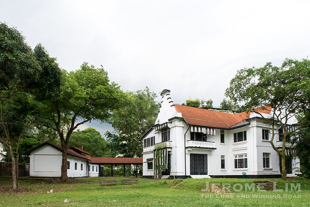
Perched on a small hill just south of hills given to the those who have passed on at Bukit Brown, is a place built as a dwelling for the living, so grand, that it has had members of royalty, a president as well as many powerful military men, find shelter within its walls. The dwelling, Command House, is well hidden from the public eye. It only is on the incline of its long driveway, well past the entrance gate at Kheam Hock Road, that we get a glimpse of its scale and appearance; the drive in also provides an appreciation of the expanse of the sprawling 11.5 acre (4.5 ha.) estate the house is set in.

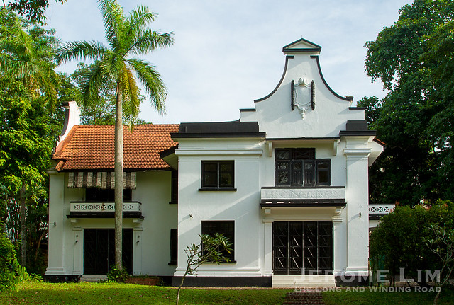
Command House at 17 Kheam Hock Road.
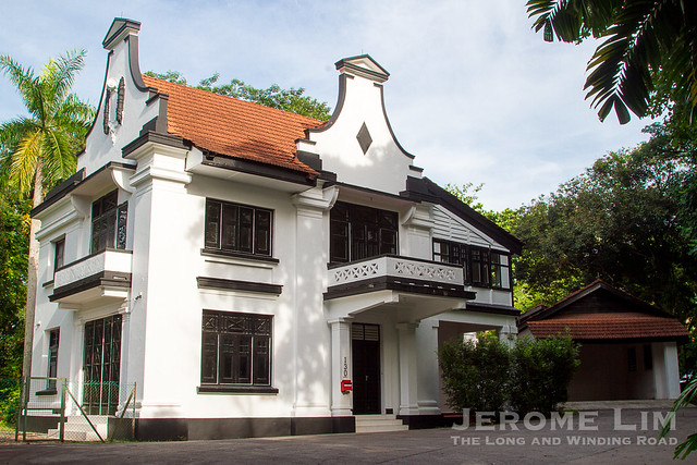
The scale of the mansion, built in 1938 with six bedrooms with bathrooms attached, a huge wine cellar as well as servants quarters and other service buildings laid out over its grounds, must impress. It however is its simple but aesthetically pleasing design that catches the eye. Said to have been inspired by the Arts and Craft movement of which its creator, the well respected Singapore based architect Frank W. Brewer, once of Swan and MacLaren, was a keen follower of, the mansion features elements of Brewer’s interpretation including the distinctive exposed brick voussoirs that is also seen in other Brewer designed houses (some examples: 5 Chatsworth Park and 1 Dalvey Estate).

Many examples of Brewer’s work feature very distinctive exposed brick voussoirs.

Several recognisable architectural contributions have been attributed to Brewer. In Singapore, these include the Cathay building and St. Andrew’s School. Visitors to Cameron Highlands would not have missed another of his works, the Tudor style Foster’s Smoke House, a landmark in the popular Malaysian mountain resort.

A Google Maps satellite view of the grounds and the surrounding area.
Built as Flagstaff House, the residence of Malaya’s most senior military commander, the importance placed on its intended occupants can be seen in the house’s grand appearance, as well as in its expansive setting and its somewhat lofty position. Flagstaff House’s completion had come at the end of decade in which the emphasis was on building Singapore up militarily to support its role as an outpost for the British in the Far East.

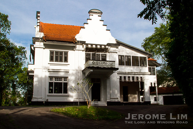
Command House after refurbishment in 2007 (photo courtesy of Singapore Land Authority).

The back of the mansion.
Laid out on a “butterfly plan”, commonly seen in the architecture of the early Arts and Crafts movement, the mansion and its beautiful grounds must be as perfect a spot as any in Singapore for a dream wedding. While that may not be possible today given the current use of Command House, playing host to a grand wedding reception was in fact what Flagstaff House’s very first act was, shortly after its completion. In September 1938, Flagstaff House played host to a reception for a wedding described in this Singapore Free Press and Mercantile Adviser article of 8 September 1938 as being “the biggest military wedding yet seen in Singapore”.


The wedding was of Lieutenant O C S Dobbie and Ms Florence Mary Dickey, held just a month or so before the house’s intended occupant, the General Officer Commanding (GOC) of Malaya, was to move in. This was possible as the groom, Lieut. Dobbie, was not only the GOC’s aide-de-camp, but also his son. Lieut. Dobbie’s proud parents, Major General W G S Dobbie, had then still not moved from the older Flagstaff House at Mount Rosie.

Two other GOCs were to occupy the house before the Japanese made nonsense of the illusions the British held of their invincibility. The last before the inglorious event was Lieutenant-General Arthur Percival, the unfortunate face of what has been described as “the worst disaster and largest capitulation in British history”. Based on an account by an eyewitness, Herman Marie De Souza, an officer in the Straits Settlements Volunteer Force, at his interview with the National Archives, the last time Percival set foot in the house would have been on Saturday 14 February 1942:
“On a Saturday afternoon, I was at Flagstaff House ground when I saw a large car approaching. I jumped to the road and stopped the car. And there was Percival in the car. I recognised him, I had met him before. And I said, I don’t think you place is very safe, because the shells are flying all the time. You hear the whizzing over. But he said he had something to do there. He went in there, and I didn’t realise he was burning his papers. And there I was holding, looking after him, sort of, until he finished what he had to do and went off. He wished me goodbye and went back to Singapore.”

Following the fall, the mansion is thought to have been used to accommodate Japanese troops. The British military commanders returned to live in the house after the occupation ended. Lord Mountbatten, the uncle of the future Duke of Edinburgh, Prince Philip, was one, he stayed in the house in his capacity as the Supreme Allied Commander, South East Asia Command, in 1946. Prince Philip, the consort to the Queen, was also to stay as a guest later, doing so during a visit to Singapore in February 1965, by which time, the property was already referred to as Command House.

In all, Flagstaff / Command House was to see some fifteen commanders pass through its doors as residents; Commanders-in-Chief of the British Far East Land Forces in the post-war period. The pull-out of British forces in 1971 gave the Singapore government possession of the property and it continued its distinguished service when it became the official residence of the Speaker of Parliament. Dr Yeoh Ghim Seng, who held the position from 1970 to 1989, was the only speaker to have taken up residence at Command House. Dr Yeoh’s successors, Mr Tan Soo Khoon in 1989 and Mr Abdullah Tarmugi in 2002, decided against using the official residence.


It was during Mr Tan’s tenure as Speaker that Command House was briefly made the official residence of the President of the Republic of Singapore, who was then Mr Ong Teng Cheong. The move was necessitated by the extensive renovations to the Istana that took place between 1996 and 1998.

Command House, when it was used as the official residence of the President. Here, we see the then High Commissioner-designate of Zambia at his ceremonial welcome in 1997 (Photo: National Archives of Singapore online catalogue).

Command House after refurbishment in 2007 (photo courtesy of Singapore Land Authority).
Today, Command House, stands not as a residence, but as a place of learning, the UBS Business University. Its tenancy was taken up in 2007 by UBS, a Swiss based financial services company, who initially used it as the UBS Wealth Management Campus-Asia Pacific, before relaunching it as the Business University. Command House was gazetted as a National Monument on 11 November 2009.


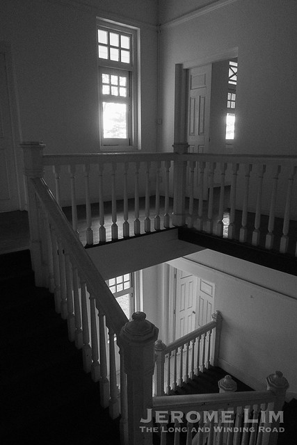
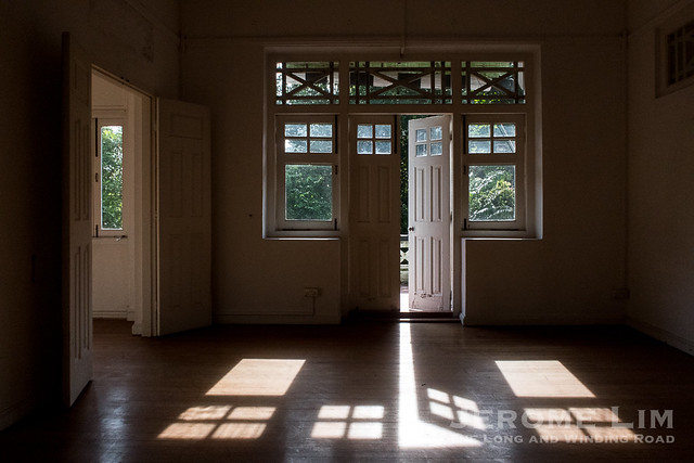
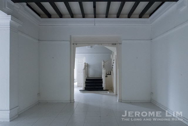
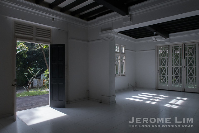
An view of the interior after refurbishment in 2007 (photo courtesy of Singapore Land Authority).

An view of the interior after refurbishment in 2007 (photo courtesy of Singapore Land Authority).

An view of the interior after refurbishment in 2007 (photo courtesy of Singapore Land Authority).


")


