Easing a different Singapore to JB jam 100 years ago

17 09 2023

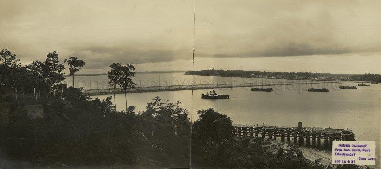
It was a hundred years ago on this very day, the 17th of September 1923, that the Causeway first came into use, when a cargo train made the crossing on tracks laid temporarily on the completed half of rubble mound which had been intended for its roadway.

A train crossing the partially completed Causeway in 1923.

Linking the island state of Singapore with Malaysia across the Straits of Johor, the one-kilometre long link is a hundred years later, one of the busiest land border crossings in the world. Hundreds of thousands cross daily with most using motor vehicles. The sheer volume of vehicles using the link does mean that traffic congestion on the Causeway and the roads leading up to it are quite a frequent occurrence, so much so that the Causeway has become synonymous with traffic jams.

A passenger train going across the Causeway in 2023.

It was in fact to solve the problems caused by heavy cross-strait traffic, albeit of a different kind, that the Causeway was built. It was also for the same reasons that Causeway was first made available for use by freight trains, which was a matter of urgency. The cross-strait movement of goods railway carriages had been made possible December 1909 when a wagon ferry built by the Tanjong Pagar Dock Board was put into operation, with a second added soon after. With the Johore State Railway (JSR) having been completed earlier in that same year, the wagon ferries permitted whole railway freight carriages to be moved between Singapore and the parts of the Malay Peninsula that the JSR and other lines that it was connected with.

Vie of the Causeway under construction with the railway wagon ferry jetty at Woodlands also in view (Tessa Mitchell Collection, National Archives of Singapore).

Fed by the growing demand for rubber in the 1910s, the volume of rail carriages carried across the strait by wagon ferry grew by leaps and bounds. In 1911, some 11,500 carriages were being carried across the strait. By 1917, cross-strait cargo wagon traffic grew five-fold with some 54,000 carriages were moved by the ferries. Carrying six freight carriages at any one time, the ferries were made to operate continuously day and night to cope with the demand, which put a huge strain on them. On the recommendation of Mr P A Anthony, the General Manager of the Federated Malay States Railway or FMSR (which had absorbed the JSR and the Singapore Government Railway by that time), a decision was taken to construct a link.

The Causeway under construction, 1923 (National Archives UK, no known copyright restrictions).

While a bridge across the strait might have been a desirable outcome, the relative ease with which a rubble causeway could be constructed and maintained together with the associated savings in cost, pushed the decision towards a causeway. Designed by consulting engineers Coode, Fitzmaurice, Wlison and Mitchell and constructed by Topham, Jones and Railton, work on the Causeway commenced in April 1920. The large amounts of granite that was required, came from either quarries in Bukit Timah, or the island of Pulau Ubin. Granite from Pulau Ubin could quite conveniently be transported by hopper barge and dumped directly on site and it was from the island that the bulk of the material came from.

A typical cross section through the rubble causeway. Most of the granite that was used came from the island of Pulau Ubin.

With granite coming by barge from Pulau Ubin, the Causeway could only be finished west to east once the gap was closed, meaning that the roadway side of its width was completed before its railway side. It was for this reason that temporary tracks were laid to permit the freight trains to use the link first. Two weeks after the link for cargo trains was established, passenger trains followed, with the first passenger train, an overnight mail train from Kuala Lumpur being the first to cross on 1st October 1923. The Causeway would only open to road traffic more than half a year later, following its completion and rescheduled official opening on the 28th of June 1924, with the very first car to cross carrying the Governor of the Straits Settlements Sir Laurence Guillemard, and Sultan Ibrahim of Johore.

The Causeway Lock under construction (National Archives UK, no known copyright restrictions).

Completed at a cost of 6.5 million Straits Dollars, three quarters of which was borne by the FMSR, some 1.5 million cubic yards (1.15 million cubic metres) of granite was used to build the 60 feet wide and 3465 feet long link. A feature of the newly completed Causeway which is no longer seen was a 50′ wide and with a 32′ clear span rolling lift bridge, and a 170 feet long lock with a width of 32 feet at the gates. Running across the Johore end of the Causeway, the lock permitted the east-west passage of small vessels such as fishing craft with the bridge fitted to cross the gap. The lock and bridge were deliberately destroyed by British-led forces as they withdrew from Malaya into Singapore on 31 January 1942 (with a 70′ gap was also blown in the Causeway). Along with the lock, ten 5 feet diameter culverts were also built into the Causeway, which allowed water to flow across the width of the link and prevented the accumulation of rubbish. The culverts, several of which were destroyed during the British January 1942 withdrawal, are now mostly out of action.

The Causeway with a gap blown into in on 31 January 1942.

The “Causeway jam” does seem to have been a perennial problem. Just two years after it opened to road traffic, the first traffic jams were reported. The jams were due to the digging up of sections of the roadway so that a pipeline to carry water from the intended Gunong Pulai Reservoir to Singapore could be laid. The post-Second World War era would see much greater traffic snarls. In 1948, increased security checks (due to the Malayan Emergency), saw to traffic hold ups. The traffic situation on the Causeway seemed to worsen through the next decade. In 1950, crowds heading to the Johore Grand Prix were reported to have caused a 3-mile (5 kilometre) traffic jam, which resulted in the start of the races being delayed. A “monster traffic jam” on 17 September 1955 β€” the 32nd anniversary of the Causeway’s first use following Sultan Ibrahim’s Diamond Jubilee celebrations resulted in 10,000 people being stranded in Johor Bahru. Festive traffic also caused traffic hold-ups, with “chaotic scenes” on the Causeway being reported during the Chinese New Year in 1959. As a result of increasing demands, the Causeway has been widened on several occasions starting with a 1.5 metre increase in its width in 1964.

The Causeway in the 1970s.

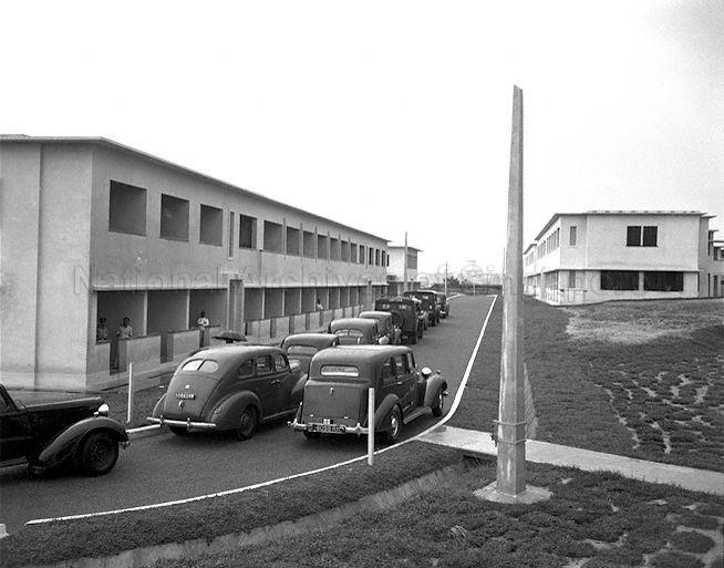
The appearance of the new Customs Checkpoint at the JB end in 1957 β€” just in time for Malaya’s independence from Britain, would be a sign of things to come. With Singapore and Malaya being pulled in opposite directions following a brief merger that ended with Singapore’s independence in 1965, immigration controls became necessary. It was however only in 1967 that full immigration controls were implemented β€” on 1st July 1967 by Singapore and on 1st September 1967 by Malaysia.

The JB Customs Checkpoint in 1957.

In 1998, a second link was opened across the strait. While this might have gone some way to ease the load on the Causeway, the sheer growth in cross-strait traffic now sees regular jams taking place on both crossings. In March 2020, the Causeway (and the Second Link) did however fall silent. This was a result of the border closures due to the global pandemic. The links were only reopened on 1 April 2022.

The Causeway fell silent due to the Covid pandemic.

Now one hundred years later, a third crossing is being established in the form of the Rapid Transit Link or RTS, a light rail line that will be carried over a 25 metre high bridge across the strait between Singapore’s Woodlands North MRT Station and Bukit Chagar in Johor Bahru. When completed in 2026, the RTS will replace the conventional railway (now reduced to the rail shuttle service between JB and Singapore run by Keretapi Tanah Melayu). And with that, Singapore’s twelve-decade long association with the conventional railway, and a hundred year conventional railway link with the Malay Peninsula β€” the Causeway’s original raison d’Γͺtre, will be brought to a close.

The RTS being built just a stone’s throw from the Causeway, a century after the Causeway was being built. The RTS will replace the KTM run shuttle service between Singapore and JB.


Goodbye to a View

30 05 2022

The pace of development in the north of Singapore, a part of the island of which I have some wonderful childhood memories of, seems to be quickening. The recent demolition of all but one of the blocks of KD Malaya and the loss of its parade square has left the section of the old naval base closest to the causeway almost unrecognisable. Nearby, former residents of another marker of memory, the former “Torpedo Lines” at Khalsa Crescent β€” most recently a prison, returned to say goodbye and have their memories collected ahead of its probable eventual demolition in an event organised by the Urban Redevelopment Authority (URA) last week. A little further east, it has already been some time since the loss of part of the elevation that played host to a UNHCR refugee camp for “Boat People” fleeing South Vietnam. The same elevation was also home to the former View Road Hospital, a branch of Woodbridge Hospital (now Institute of Mental Health), which stood at its top. The building that housed it, which dates back to 1941 and is still standing, is a longtime marker that if the URA Master Plan for the area is to be realised, may also soon disappear from sight.

The observation tower at View Road.

Although the former View Road Hospital, once also a home to Asian Naval Base Policemen and their families may be of little architectural value and of little significance in the whole scheme of buildings within the former naval base, it has, since I started conducting tours in collaboration with the Singapore Land Authority (SLA) in 2017, has become one of my favourite places. Why that is so is for the views one is able to get from its lookout tower, one that now provides an idea of the scale of redevelopment that is taking place in and around it. An example of the development work that is now in evidence, is the Rail Transit System link that will connect Woodlands North to Bukit Chagar in Johor Bahru via a 25 metre high bridge. Scheduled to open by the end of 2026, it will transform the area into a major entry point for cross border human traffic with its peak capacity of 10,000 passengers per hour.

Among the other developments that is already taking place in the area, is that of the future Woodlands North Coast, a component the overall Woodland Regional Centre. Based on the URA Master Plane, that does appear to spell the end for the former hospital.

The future of View Road (URA Master Plan 2019).


Parting Glances: Khalsa Crescent, home turned prison

24 05 2022

Once home to a huge naval base that stretched from the Causeway to Sembawang Road, Singapore’s rather sleepy northern coast seems set for a huge transformation. Work to build a much-anticipated rail transit system link to Johor Bahru is already underway and the signs are that the ground is already being prepared for a role as key component of the future Woodlands Regional Centre. The demolition of much of the former KD Malaya complex is now already complete, and all that is left of the longtime landmark, sited in an area close to Woodlands North MRT Station is gone, save for the conserved administration building. One set of structures that may likely disappear is the former quarters at Khalsa Crescent, which many of us would only know as Khalsa Crescent Prison.

The former Khalsa Crescent Prison, which has a much storied past. Block 6 (Prison Block F) was used as accommodation for policemen and featured a recreational space below where lectures and police parties during Sikh religious festivals were held. The space also functioned as a games room.
The watchtowers of the former prison are what draws notice to the complex.

Built in 1950 on the site of the Torpedo Depot “coolie lines”, Khalsa Crescent (Asian) quarters provided Asian members of the naval base workforce and their families, with a roof over their heads. Among those who were housed on the site were members of the Naval Base Police Force and the Naval Base Fire Service, for whom the set of quarters was affectionately known as “Torpedo”, having been know initially as “Torpedo Depot Lines”. When built, the quarters comprised seven two-storey blocks cont laid out with some 170 rooms that could accommodate up to 180 families. Among the blocks were ones housing bachelors with common spaces such as rest and mess rooms and recreational spaces found on the ground floors. Flag Officer (Malaya), Rear Admiral Clifford Caslon, who opened the estate on 10 January 1950, described the construction of new housing units as evidence that interest to the welfare and comfort of the base’s civilian staff was being shown by the Admiralty.

The newly built accommodation blocks in 1950, with Blocks 1 and 2 (far end) on the left, and Blocks 3 (far end) and 4 on the right.
The scene today.

During its first years, the quarters accommodated a fair number of Sikhs families, who men served in the Naval Base Police Force. As a result of this, a gurdwara was established in the eastern section of the ground floor of Block 5. Due to this association with the Sikh members of the force, the road through the estate was named “Khalsa”, which means “pure” in Punjabi. Khalsa, which also describes the guiding principle of the Sikh religion community, is often used as a reference to the Sikh community. The gurdwara moved to View Road (Rimau), where an Asian Naval Base Police Barracks was established, together with the Sikh policemen and their families in 1959. Some naval base policemen continued to stay in Khalsa Crescent while there were others who also relocated to Cochrane Crescent at about the same time. In the 1960s, a surau for Muslim policemen and their families was established at Block 5.

The section of Block 5 where I am told the gurdwara was.

The British military pullout, which took place at the end of October 1971, also saw to the eventual disbandment of the various services associated with the naval base and while the quarters continued in their use as accommodation units, the winds of change would eventually blow through the estate. In late 1974, some three years after the pullout, several of the accommodation blocks at Khalsa Crescent were converted for use as a remand centre and the forerunner of the DrugΒ RehabilitationΒ Centre (DRC) β€” the DRC system was apparently formalised in 1977, although the term was already in use – as part of a broader scheme to segregate drug inmates (also according to the number of times they were hauled in). But while this may have been the intention, one of the centre’s first uses was for the detention of illegal immigrants, more specifically a group of 56 who had fled South Vietnam as the situation deteriorated in the lead up to the Fall of Saigon in April 1975. The group of 56, with 18 women and 10 children among them, arrived on a stolen military plane on 3 April 1975. Having come without the necessary visas, they were detained as illegal immigrants and were held at Khalsa Crescent where they spent 3 weeks, after which they were sent on to Guam.

A view of the former prison.

This drug rehabilitation scheme saw further changes to it and by 1995, drug addicts would first be sent to Sembawang DRC, where they would be observed and further processing was carried out. They would then be placed based on their previous records. Khalsa Crescent DRC was where third time offenders were sent to. Khalsa Crescent’s capacity was increased from 500 to 1050 during a renovation exercise that was carried out in anticipation of this new arrangement. In June 2005, Khalsa Crescent DRC became simply Khalsa Crescent Prison.

Members of the Khalsa Crescent Sikh Community.

The modernisation and expansion of the Changi Prison complex in 2009, saw to the move of some 5000 inmates from prisons like Khalsa Crescent Prison, which was described as the “largest transfer of prisoners in local history”. What that also meant was that older facilities such as Khalsa Crescent Prison were made redundant and surplus to requirements. Decommissioned, the former prison lay hidden behind its tall green security fence β€” that is until 21 May 2022 when former residents of the one-time Asian quarters were allowed to take a short but sweet walk back in time in anticipation of the complex’s eventual demolition.

Memories of Khalsa Crescent.

Vietnamese Refugees in Singapore
Following the incident involving the 56 refugees arriving by plane, the opium treatment centre at St John’s Island was temporarily set aside for refugees. Addicts under treatment on the island displaced by the arrangements were then moved to Khalsa Crescent Remand Centre, where the 56 had been held. The island refugee camp would be closed in October 1975 and subsequent to that, Singapore took a strong stand against refugees who began to leave the former South Vietnam by boat. A policy of restocking refugee boats before towing the boats back out to sea was initially put in place. It would only be in 1978 at a time when the refugee crisis reached its peak that Singapore permitted refugees to land on the condition that a guarantee was made of resettlement in a third country within three months by the United Nations High Commissioner for Refugees (UNHCR). The UNHCR was also allowed to set up and run a refugee camp at Hawkins Road, not far from Khalsa Crescent.


The evolution of the area through maps and aerials

Maps of the Torpedo Depot area showing the former coolie lines in 1945 and the blocks of the Asian quarters in 1968.
Plans of the site before and after the quarters were built.
Aerial views of the site during the time of the coolie lines and after the barracks were built (Maps from National Archives of Singapore)
What the crystal ball that is the URA Master Plan says that the Khalsa Crescent will be – a future residential development.

A walk around the former prison

The caged passageway built for the prison along the former Block 5, which became the prison’s Admin Block.
An Interview Room in the Admin Block.
A passageway between the Admin Block and the Workshop section of the prison.
A view towards the former RMN Sports Grounds, where the Rail Transit System link from Woodlands North to Bukit Chagar in Johor Bahru is being built.
Inside Workshop 2, one of two prison workshops that were added during the prison days.
Inside a second workshop.
Staircase at Block 7, which was apparently a bachelors’ block.
Block 7, which had bachelors’ accommodation on the top. A Sikh cook prepared meals for the bachelors according to one former resident.
The Kitchen at Block 7.
Potential weapons have to be kept safe.
The Housing Unit – the roof was added to allow the space between the former accommodation and service blocks to be usable.

Inside a “Housing Unit”


More views of the former prison


Breaking KD Malaya’s last ship up

11 03 2022

For those whose connection with Singapore’s far north go back to the 20th century, the road to the causeway was one littered with an interesting range of sights. One such sight that would certainly have caught the eye, was that of KD Malaya, a camp from which Malaysia’s navy – Tentera Laut DiRaja Malaysia (TLDM) or Royal Malaysian Navy (RMN) had its fleet based at until 1979, and which was used as a TLDM training facility right until 1997.

KD Malaya from Admiralty Road West – the layout of the buildings gave an appearance of the bow of a huge ship.

The centrepiece of the base was it large parade ground, beyond which an administrative building and two barrack buildings took on the appearance of the bow of a huge ship with the camp’s flagstaff seemingly a foremast. This was quite a remarkable sight, as one came around an area of Admiralty Road West that contained Hawkins Road refugee camp and View Road Hospital (the area was featured in Secrets in the Hood Episode 5).

The former KD Malaya, seen in 2020 after Admiralty West Prison vacated it.

The wondrous sight of the former KD Malaya is now one has quite sadly been lost to the frenzy of redevelopment has now reached Singapore’s once sleepy north, with the Woodlands North Coast development beginning to take shape. While the camp’s streamline moderne inspired former administration block may have been kept for posterity, the two barrack buildings that contributed to the sight has since been demolished. Along with that, the parade square, which had provided the setback to take the wonderful view in, has also been consigned to history. This breaking of a link with our shared history with Malaysia, through the removal of a significant physical reminder of it seems especially ironic with the development nearby of a new link to Malaysia through the Rapid Transit System.

Only the administration block remains today (with a granite-faced staircase leading up to it).

I shall miss the sight of the former KD Malaya, with which I have been familiar with since my childhood. Together with the wonderful spaces and landmarks in and around it, it has provided great joy and comfort, especially with much of the rest of a Singapore being transformed in a way made it hard to identify with. While KD Malaya’s administration block is being kept, my fear is that it becomes just another building in a space overcrowded with a clutter of structures of a brave new world – as seems the case many other developments in which heritage structures are present. An example is the transformation of the joyously green space around old Admiralty House into the monstrous Bukit Canberra development into which a ridiculous amount of concrete has been poured in and around which a clutter of structures has conspired to reduce the presence of the stately arts and crafts movement inspired old Admiralty House.

A road is being built around the site.

There is also the matter of KD Malaya’s gateposts, which will have to be relocated. Whatever happens to it and wherever it will eventually be re-sited, my hope is that it doesn’t go the way of the old National Library’s gateposts. Originally left in situ to mark the site of a much loved Singaporean building, the gateposts have since suffered the indignity of being displaced and put in a position in which it has become …. just another part of the scene.

KD Malaya’s old gate.
The road to perdition. Work on the Rapid Transit System is taking place, which will cross over that body of water that is seen to Johor Bahru.
Will the former Rimau Offices / View Road Hospital (and its unusual above ground “bomb-proof” office) be the next to go?


Lost places: Woodlands Town Centre

24 10 2019

The old Woodlands Town Centre, with its proximity to the checkpoint and the causeway, could have been thought of as a border post.

It certainly felt like it, with scores of folks crossing the causeway from Johor Bahru – many on foot – thronging the busy bus terminal and the shops in the old centre.Β  Completed in 1980/81, the centre belonged to the generation of Housing and Development Board (HDB) designs that followed on the second generation Ang Mo Kio, Bedok and Clementi New Town projects.

A unique feature the town centre was given was a bazaar, which house 88 shops resettled from the length of Woodlands Road. The town centre’s air-conditioned shopping complex could also be thought of as a pioneering attempt by the HDB to venture into shopping complex development.

Vacated in 2017, its proximity to the causeway was probably a contribution to its demise – part the the site which the now demolished centre occupies will be used to build an extension to the especially busy Woodlands Checkpoint.

A plan of Woodlands Town Centre (source: HDB).


Photographs:


The old bus terminal.


Woodlands Cinema.


\


Discovering the former View Road Hospital (2019)

15 07 2019

Registration for the event has closed as of 7.40 pm on 15 July 2019.

More on the series, which is being organised in collaboration with the Singapore Land Authority (SLA):Β Discovering Singapore’s Best Kept Secrets.


No. 10 View Road is perhaps best known as the former View Road Hospital, aΒ branch of Woodbridge Hospital (now the Institute of Mental Health) until the early 2000s. The hospital housed and treated patients undergoing rehabilitation with many finding employment in the area.

sh_01

The complex, which sits on a hill close to Woodlands Waterfront, does have a much longer history. Completed in late 1941 in the western side of the Admiralty’s huge naval base, its grounds also contains a unique above-ground bomb-proof office. The building also provided accommodation for the Naval Base Police Force’s Asian policemen and their families from the late 1950s to 1972, during which time the Gurdwara Sabha Naval Police – a Sikh temple that has since merged with the Gurdwara Sahib Yishun – was found on its grounds. The building has also been re-purposed in recent times as as a foreign workers dormitory.

IMG_2006

The visit, which is supported by the Singapore Land Authority (SLA), provides participants with the opportunity to learn more about the site through a guided walk through parts of the property.

IMG_2008


When and where:
27 July 2019, 10 am to 11.30 am
10 View Rd Singapore 757918

How to register:

Do note that spaces are limited and as this is a repeat visit, kindly register only if you have not previously participated.

Participants must be of ages 18 and above.

A unique registration is required for each participant. Duplicate registrations in the same name will count as one.

Registration shall be made using the form at this link (closed as of 7.40 pm 15 Jul 2019).

A confirmation will be sent to the email address used in registration to all successful registrants one week prior to the visit. This email will confirm your place and also include instructions pertaining to the visit. Please ensure that the address entered on the form is correct.


A voice from View Road’s past

2 11 2017

A voice from the former View Road Hospital’s past: an ex-resident Roszelan Mohd Yusof from theΒ days when it was the Naval Base Police Asian Quarters, revisits the units in which he lived from the 1960s up to 1972 (see video below).

Best known as a former mental hospital (used as a rehabilitation centre from 1975 to 2001 for long-term schizophrenia patients as well as to allow them to work, reintegrate and return to society), the building had prior to that been used as a quarters for Asian Naval Base Policemen and their families.

A large proportion of the residents of the quarters were Sikhs and Malays. There was also a Pakistani family, and a Bangladeshi family living there, as well as one Nepali family.Β  The lower floor of the north wing, whichΒ  housed the Chart Depot, was out of bounds to the residents, as well as the observation tower and the bomb-proof office.

The last Naval Base Police Force residents were allowed to vacate their flats in 1972, following the disbandment of the Naval Base Police Force a month after the British Pull-out.Β  More of what is known on the building’s history is also seen in the video.


More on the former View Road Hospital and the visit that was organised to it:


Discovering Singapore’s Best Kept Secrets : Visit to View Road Lodge

9 10 2017

See aslo : A Voice from View Road’s Past


The Singapore Land Authority (SLA) has kindly granted permission for a series of guided State Property visits, “Discovering Singapore’s Best Kept Secrets”, the seventh of which will be to the former View Road Lodge – best known perhaps for its time as the View Road (Mental) Hospital.

IMG_3515sa

View Road Lodge in January 2011.

As a branch of Woodbridge Hospital (now the Institute of Mental Health) that operated from 1975 to 2001, View Road Hospital was used to house and treat recovering patients from Woodbridge. Many of View Road’s patients were in fact well enough to find work in day jobs outside of the hospital, which also operated a laundry, a cafe and a day-care centre with patients’ help.

IMG_5376Thought to have been completed just prior to the outbreak of war in late 1941, it is also known that the building was put to use as accommodation for Asian policemen (with the Naval Base Police Force) and their families from the end of the 1950s to around 1972. During this time, the Gurdwara Sabha Naval Police – a Sikh temple, operated on the grounds. As View Road Lodge, the building was re-purposed on two occasions as a foreign workers dormitory.

IMG_5359

The visit will also include a rare opportunity to have a look at an above ground bomb-shelter that had been constructedΒ as part of the complex in 1941.

Rimau “Bomb-Proof” Office, 1941 (National Archives UK).

The details of the visit are as follows:

Date : 21 October 2017
Time : 10 am to 12 noon
Address: 10 View Road Singapore 757918

Participants should be of age 18 and above.

Kindly register only if you are able to make the visit by filling the form in below.

Registrations will close when the event limit of 30 registrants has been reached or on 14 October 2017 at 2359 hours, whichever comes first.

More on the property : Rooms with more than a view


Further information on the series / highlights of selected visits:


The Italian captain who bought Pulau Bukom …

10 06 2017

Except perhaps for sculptor Cavaliere Rodolfo Nolli, whose magnificent work adorns the old Supreme Court, little is known of Singapore’s many connections with the Italian community – except perhaps of the community’s many culinary offerings we are now able to find. It may therefore come as a surprise that the connections do go well back – Β even before Italy as an entity existed and that Singapore’s Pulau Bukom was once owned by an Italian man.

Explore Singapore’s surprising Italian connections at The Italian Connection at the Fullerton Hotel.

Pulau Bukom is perhaps better known to us as the island on which Singapore’s successful journey into the oil refining trade, had its beginnings. Shell, who built and operate the refinery, has long been associated with the island. 20 acres of it was bought by the company in 1891 for the purpose of kerosene storage. The transaction netted the island’s owner, Β Capitano Giovanni Gaggino a tidy profit. Gaggino, an Italian master mariner, shipowner and adventurer, purchased the island for $500 in 1884 with the intention to supply freshwater to shipping. His purchase of “Freshwater Island” as it was informally known as, was one of many of Gaggino’s ventures here. He would spend 42 of his 72 years in Singapore from 1876 and passed on in 1918, whilst on a trip toΒ Batavia. Capitano Gaggino was also known to have authored several books, one of which was the very first Malay-Italian dictionary.

Capitano Giovanni Gaggino, who once owned Pulau Bukom (source: Reproduction of β€œLa Vallata del Yang-Tse-Kiang” by the Italian Ministry of Foreign Affairs. Open source).

Even before Gaggino, Italians – many of whom were involved in shipping and trade, made landfall. One rather famous Italian, the renowned botanist and contemporary of Charles Darwin, Odoardo Beccari, used Singapore as a stepping stone to his well documented explorations of the region’s forests. Credited with the discovery of the giant corpse flower, Beccari also documented a month he spent in March 1866 at the “wooden bungalow” of the Italian Consul, Signor Giovanni Leveson (a.k.a. Edward John Leveson) on the Johor Strait. The bungalow is thought to be where Woodlands in Singapore’s north got its name from.

Odoardo Beccari (source: Sailko, Creative Commons License 3.0).

Like Capitano Gaggino, Cavaliere Rodolfo Nolli spent a substantial part of his life in Singapore. He arrived from Bangkok in 1921 and remained – except for a period of internment during the Second World War (as a citizen of Italy, one of the Axis states, he was interned in Australia from 1941 to 1945), until his retirement in 1956 . He worked tirelessly and amassed a huge portfolio of work that began with theΒ second Ocean Building on which he provided the decorative artificial stone facings.

Composite image of Rodolfo Nolli and the main (south) entrance of the GPO. Two sets of works – the coat of arms and a pair of flambeau compositions, went missing during the Japanese Occupation (source of images: National Archives of Singapore).

The majestic Ocean Building did not only launch Nolli’s career in Singapore, it also spelled a new era for the bund along Collyer Quay. Before the end of a decade, three even grander edifices would be added: the Union Building, a second generation Hongkong and Shanghai Bank Chambers, and the grandest of them all, the Fullerton Building. The additions, all of which Nolli had work done on, provided the bund with an appearance that could be compared to Shanghai’s more famous embankment.

Ocean Building in the 1920s (Source: W. A. Laxton, The Straits Steamship Fleets)..

Built to house the General Post Office, several municipal offices as well as the exclusive Singapore Club, the Fullerton was decorated with some of Nolli’s more exquisite pieces of the era. Two precast sculptural works: a pair of flambeau compositions and a royal coat of arms – symbols of enlightenment and empire – adorned the main entrance to the GPO. Sadly, these disappeared during the Japanese Occupation and all that can now be seen of Nolli’s contributions in the building is the magnificent plasterwork of the barrel vaulted ceiling of the Singapore Club’s Billiard Hall. The hall is now the Straits Room of The Fullerton Hotel. The hotel has occupied the Fullerton Building since 2001.

The Straits Room is now where the only works of Rodolfo Nolli’s in the Fullerton Building to have survived can be found.

The historic waterfront, 1932, to which Nolli added decorative finishing touches, and the waterfront today (source: top image, Singapore Philatelic Museum; lower image, Jerome Lim).

Cavaliere Rodolfo Nolli, whose works are also found in Bangkok – where he spent 7 years of his life, in parts of Malaysia and also in Brunei, was bestowed with a knighthood by the Italian Crown in 1925. This is an honour that another Italian gentleman connected with the Fullerton Building, Cavaliere Giovanni Viterale, has also received. Cavaliere Viterale, the GM of Fullerton Heritage, is a well respected member of the hospitality industry and it was for his contributions to it that he received the honour. The building, which wasΒ opened in June 1928, celebrates its 89th anniversary this month.

Nuns of the Canossian order speaking to Cavaliere Giovanni Viterale at the exhibition opening. The order, which has origins in Italy, first arrived in Singapore in 1894 (source: The Fullerton Heritage).

More on the Italian Community, including on an Italian order of missionaries whose work in tending to those in need continues to this very day, the Canossian Daughters of Charity, can be discovered at an exhibition that I curated with Zinke Aw, “The Italian Connection”. The exhibition, The Fullerton Hotel’s East Garden Foyer, runs until 18 July 2017. Information on the exhibition can also be found atΒ The Fullerton Heritage’s websiteΒ and throughΒ the official press release.


More northern light

19 04 2016

Another dramatic show of light captured along Singapore’s northern coast,Β this one after sunsetΒ at 7.18 pmΒ onΒ the 15th of June 2014. The view isΒ towards the Shell Woodlands jetty and across the Straits of Johor over to Johor Bahru. The point at which this was captured is in the are of Woodland Waterfront where the Royal Malaysian Navy maintained theirΒ main naval base, KD Malaya,Β until 1979.


The magazine under Talbot’s Hill

7 02 2015

An area of Singapore that still has much history buried under it is the area where the former British Naval Base was. Under parts of the former base, which covered an area stretchingΒ from the Causeway in Woodlands to what is today Sembawang Park, lies several underground structures, one of which is a the so-called Attap Valley bunker that has recently been brought to light.

The entrance to the Attap Valley bunker.

The entrance to the Attap Valley bunker below Talbot’s Hill.

Worshipping a new religion? Participants on a heritage tour to the site examining part of a ventilation system.

Worshipping a new religion? Participants on a heritage tour to the site examining part of a ventilation system.

The bunker, opened to the public for the first time today, is theΒ last survivingΒ structureΒ of an armament depot constructed by the British within the huge Naval Base in the Talbot’s Hill and Attap Valley area. A ammunition and armament storage magazine, specifically Magazine No. 4, it was one of seven other bomb-proof magazines that were built into Talbot’s Hill by the British before 1942.

An extract of a 1945 map of the Naval Base showing the area and the layout of the ammunition depot, including the seven magazines under Talbot's Hill.

An extract of a 1945 map of the Naval Base showing the area and the layout of the ammunition depot, including the seven magazines under Talbot’s Hill (click to enlarge).

The National Heritage Board (NHB), which has been studying the site since April 2014, has also established with the help of a 1945 map of the Naval Base, thatΒ the magazines were part of a network of eighteen bunkers, warehouses and workshops spread over the Attap Valley site, that formed the Royal Naval Armament Depot.

The tour group being led into the bunker.

The tour group being led into the bunker.

The passage to the storage area.

The passage to the storage area.

Evidence points to the magazine, which is the size of two 5-room HDB flats, being used by the Japanese during the occupation – a cache of Japanese weapons and ammunition was found by MINDEF when they usedΒ the site for the Sembawang Ammunition Depot.

The storage area where  corrugated ceiling reinforcements can be seen along with a gantry hoist.

The storage area where corrugated ceiling reinforcements can be seen along with a gantry hoist.

What appears to be a light fitting from the time of the bunker's construction.

What appears to be a light fitting from the time of the bunker’s construction mounted on the ceiling.

According to NHB, part of the floor of the bunker, now a mess of mud and water, would have hadΒ rail tracks running over them to allow the ammunition to be moved in and out, accounting for the rusty colour of the mud and water in the bunker. While there is nothing left of the tracks to be found, there are several fixtures and fittings that mightΒ have originally been there at the time of its completion. This includes vents from an all important ventilation system, light fixtures, and pipes. A travelling gantry hoist, complete with a sign giving its Safe Working Load rating, can be seen in the inner chamber where the ammunition would have been stored. Access into the inner chamber is via a curved passageway designed so as explosions could beΒ contained.

JeromeLim-8223

Talbot’sΒ Hill and the surviving magazine under it now lies well within a fenced up area of land, which wasΒ returnedΒ to the State byΒ  MINDEF when the depot was decommissioned in 2002. Access to it is only via the NHB tours, being organised as part of a Battle of Singapore commemoration that coincides with the 73 anniversary of the Fall of Singapore and also the 70 anniversary of the liberation in September 1945. More information on this, including theΒ Case Files from the Singapore War Crimes Tribunal Exhibition scheduled to open next week at the National Museum of Singapore, can be found at the NHB website.

More photographs of the bunker and its surroundings

JeromeLim-8277

JeromeLim-8290

JeromeLim-8181

JeromeLim-8228

JeromeLim-8244

JeromeLim-8257

JeromeLim-8263

JeromeLim-8247

JeromeLim-8272


Postscript
An account relating to the last days of the Royal Naval Armament Depot before the Fall of Singapore: A Singapore Story – 1942.


Light after dark (The West End)

28 08 2013

A view along the Straits of Johor, in the area where the Malaysian Navy had once maintained a base which served as their main base until 1979, some 15 years following the separation of Singapore from Malaysia. The view, taken at 7.41 pm on 25 August 2013, is one taken across what would have been the west end of the huge British naval base towards what would have been Rotherham GateΒ to the left of the picture, the Causeway in the middle and Johor Bahru in Malaysia to the right. The jetty seen in the photograph is the Shell or Woodlands Jetty which is still in use. The area is one I made a first acquaintance with back in the early 1970s, after the area had been opened up following the withdrawal of British forces in 1971.Β That was when the since demolished derelict Ruthenia Oiling Jetty, served as one of two places along Singapore’s northern coastline to which my father would take me to drop crab nets from. The area has since been remade and is now referred to as the Woodlands Waterfront.

277A0482


Sunset over the strait

27 08 2013

The setting sun over Johor Bahru, seen across the Tebrau Strait or Straits of Johor from Woodlands at 7.04 pm on 25 Aug 2013.

277A0451


Rooms with more than a view

28 07 2013

Tucked away on a hill some 38 metres above street level is a disused building that has gained a reputation for all the wrong reasons. Better known to most for what it has most recently been used for – the View Road Hospital, it has an uncertain beginning and was in the last days of the Naval Base, a barracks to house Asians in service with the Naval Base Police.

IMG_9915

The Naval Base Police, established at the completion of the Naval Base in 1938/39, was disbanded when the British forces pulled out in 1971. It counted in its ranks a large contingent of Sikh policemen, and later Pakistanis and Malays. A Sikh temple, the Gurdwara Sabha Naval Police has been closely associated with the force and from the time the barracks was established at View Road in 1959-60 until 1971-72, that was located right next to the barracks. The temple merged with another temple the Gurdwara Sahib Guru Khalsa Sabha Sembawang (Sembawang Sikh Temple) with the disbandment of the Naval Base Police in 1971. The Sembawang Sikh Temple in turn merged with the Gudwara Sahib Jalan Kayu as the Gurdwara Sahib YishunΒ and is now located at Yishun.

A July 1941 photograph showing Rimau Offices and Accommodation in the early stages of construction (National Archives UK via National Archives of Singapore online).

The Gurdwara at View Road Barracks, 1971

The gurdwara, at its closing in October 1971 (photo courtesy of Sheila Singh Sidhu).

The former View Road Hospital’s building goes a little further back. It would seem that it may have been completed in late 1941 (a 1944 map of the Naval Base – based on information developed prior to the outbreak of war – has it identified as the uncompleted “Rimau Offices”). A photograph dated 21 July 1941 from the National Archives UK shows in the very early stages of construction and another showing it almost complete in 1941. A photograph of an above-ground bomb-proof office on the site – above-ground possibly because it was built in a hurry, shows it in the late stages of completion in July 1941. Also an updated map of the Naval Base printed in 1945 shows the building completed.

img0077

Rimau Offices nearing completion in 1941 (National Archives UK via National Archives of Singapore online).

img0360

Rimau Bomb-Proof Office nearing completion in July 1941 (National Archives UK via National Archives of Singapore online).

BATU RIMAU DEC 1944 Intel Report

AA gun positions and buildings around the Bukit Rimau area, including Rimau Offices from a 1944 intelligence report.

From a 1968 edition of the map of the Naval Base, we see that it was the Naval Base Police Asian Quarters with the words “Old Maritime HQ” in parenthesis – indicating that it was built for either the RAF or the Fleet Air Arm of the Royal Navy for use it as a command centre for maritime air operations (hence the observation tower found on the building and also the “bomb-proof office” next to it). An RAF proposal to use it as such fell through in the 1950s due to signal interference at from nearby SUARA Wireless Transmitting Station. It would have only been around 1960, possibly the late 1950s, that the building was converted into a much needed barracks for Asian Naval Police personnel, many of whom had taken to renting accommodation outside the base due to shortage of quarters.

1944 War Office drawn Naval Base Map based on pre-war information.

Aug 1945 Naval Base Map showing building in place.

Following the pullout of the British forces, the building was converted for use as an secondary hospital to supplement the overcrowded Woodbridge Hospital, providing rehabilitation for recovering mental patients, particularly those with chronic schizophrenia. The first batch of 34 patients were moved into the 250 bed hopsital in September 1975. The rehabilitation Β programme included providing skills training to the patients to allow the patients to return to society. A large group of about 100 would in fact be permitted to work outside the hospital, which was already running a laundry, a nursery and a cafe, in the day. The hospital was shut in 2001. The building has seen use as the View Road Lodge – a foreign workers’ dormitory – which was in use until a few years back. The building today lies unoccupied.

IMG_2006

A visit to the observation tower.

View Road Lodge in January 2011.

As the View Road Lodge in January 2011.

IMG_5359

The Bomb-Proof Office seen in Oct 2017.


A view down the Strait

8 07 2013

The view northwestwards down the Straits of Johor from Kampong Wak Hassan is one which would have once looked across to the part of the strait where theΒ huge naval baseΒ which was completed in 1938 by the British. The base which stretched from what is Sembawang Park today all the way along the strait to what today is the west end of Woodlands Waterfront close to the Causeway, was opened up in 1971, allowing public access to what was a restricted area.

A view down the Strait

The view down the Strait at 6.52 am this morning.

The area is one I have had many interactions with since the 1970s. The jetty seen in the photograph, is one I spent many nights at fishing for crabs as was another jetty at the west end of the former base – the then already derelict Ruthenia Oiling Jetty which has since been demolished. The 1970s were interesting times for the area, with the opening up of it allowing some parts of the area to be exploited for non-military use. One use of a small part of the area one was perhaps oneΒ we in modern Singapore have largely forgotten, a reminder of a period of South-East Asian history when times were less certain. This particular use will be one of the subjects of an exploration by two popular television personalities for an episode on the Woodlands area of a Chinese TV series, Secrets in the Hood, to be televised on Channel U on 3 September 2013. Do look out for it and other interesting hidden secrets from neighbourhoods across the heartlands of Singapore in the series which will air from 6 August to 13 September 2013 in the 9 to 10 pm slot.

A popular TV personality will be exploring the area in an episode of a Chinese television series which will be aired on 3 September on Channel U.

A popular TV personality will be exploring the area in an episode of a Chinese television series which will be aired on 3 September on Channel U.


The sun sets on the first half of 2013

4 07 2013

Colours after the sunset, 7.16 pm, 30 June 2013, taken from the former Royal Malaysian Navy jetty at Woodlands Waterfront looking across towards Johor Bahru.

277A4979


Last post standing

16 07 2012

Standing somewhat forgotten and hidden under the roots of a tree is a marker of what used to be the perimeter of what had once been described as the largest naval base east of the Suez – the Royal Navy base at Sembawang that extended for some six and a half kilometres as the crow flies from Woodlands (close to the Causeway) to Sembawang (where Sembawang Park is today). The marker, a gate post belonging to the former Rotherham Gate, the northernmost gate into the former base, is the last remnant of several entrances into the huge naval facility that had once been the pride of the British Empire and a significant source of employment for residents of Singapore.

Rotherham Gate in the 1960s (source: Derek Tait).

The gate located at the western edge of the Naval Base and one of the main entrances into the base (the others being Sembawang Gate and Canberra Gate to the east and the southeast) was renamed as the Rotherham Gate in 1945 in commemoration of the role of the Commander of the RN Destroyer HMS Rotherham in the acceptance of the surrender of men from the Japanese Imperial Navy at the Naval Base in September 1945. Along with the other gates, the gate was manned by security personnel deployed by the Royal Navy stationed at the guard-houses that had once stood by the entrances, right until the end of October 1971 when British Forces formally withdrew from Singapore. Remnants of some of the gates in the form of gate posts and guard posts had in fact stood for some time after including that of the Rotherham Gate. Based on an account by a former resident of the base, Mr Kamal Abu Serah, the guard-house that had stood inside the gate had actually housed a provision shop after the opening up of the Naval Base in 1971.

The area where the Rotherham Gate once stood. The last post standing is now gripped tightly by a tree which has taken root on the post.

Hidden behind the roots of a tree and parasitic plants which have also taken root on the tree is the last post standing … close examination reveals a rectangular concrete column beneath the tree’s roots.

The gate post today, serves as a marker of the western end of what is the recent redeveloped Woodlands Waterfront , an area that for a long while had been left behind by the pace of redevelopment that has swept through much of the rest of Singapore. The area had after the opening up of the Naval Base, long been a haunt for anglers and was in fact one of the places that I frequented in the 1970s for fishing and to catch crabs. A derelict jetty which was missing most of its deck planks had been one of two jetties that my father sometimes took me to. The jetty, the old Ruthenia Oiling jetty (which my father had referred to as the Naval Base jetty) has since been demolished. It was one of several jetties that jutted out of the coastline in the area, the only one that was accessible to the public in the 1970s and became quite a popular spot for crab fishing before it was demolished. The other jetties were the Customs Jetty, the Shell Jetty (Woodlands Jetty), and the large L-shaped jetty that was used by the Royal Malaysian Navy – the Tentera Laut Diraja Malaysia (TLDM).

Parts of a 1968 map showing the location of the Rotherham Gate, the perimeter fencing and the position of the four jetties in the area (source: Ms Nora Abdul Rahman).

The TLDM had maintained not just a large jetty in the area – Woodlands had in fact hosted the main base of the TLDM, KD Malaya, up until 1979, the base having first been established in 1949 with the setting up of the Malayan Naval Forces (MNF). The TLDM continued to operate KD Malaya as a training facility even after the shift of the main naval base to Lumut up until December 1997 together with the jetty. The jetty has since been incorporated as part of the Woodlands Waterfront redevelopment and is now opened to the public. Both the jetty and the former TLDM barracks, which can be seen along Admiralty Road West, remain as a reminder of the Malaysian navy’s long-standing presence in what was an independent Singapore.

Part of the former TLDM jetty, now opened to the public, seen at dusk.

The view across the straits to Malaysia … Malaysia operated a Naval Base across the straits in Singapore up until 1997.

In between the Shell Jetty and the former TLDM Jetty is where a river, Sungei Cina, spills into the sea. Sungei Cina, for most part, still has its natural banks. The vegetation that one finds along its banks is probably representative of the vegetation which would have been found along much of the swampy shoreline that had existed before extensive reclamation work during part of the ten years it took to construct the base in between 1928 to 1938 – construction which saw substantial parts of the coastal swampland filled with earth – some of which came from excavation work around where the Naval Dockyard was being constructed to the east of the Naval Base. A large part of the land on which the Naval Base had been built was that which had acquired by the Straits Settlements from belonged to the Bukit Sembawang rubber estate and given to the Royal Navy for its use. The huge excavations around the area of the Naval Dockyard was not just to provide a dockyard that since 1968 has been used by Sembawang Shipyard, it also provided the largest naval graving (dry) dock in the world when it was opened in February 1938 – the King George VI dock (known also as ‘KG6’) which is still one of the largest dry docks in South East Asia.

A swamp once extended along the shoreline of what is now the well manicured Woodlands Waterfront – a waterfront that even before its redevelopment has attracted many anglers to the area. The Senoko Power Station and the Shell Jetty can be seen at the far end of the shoreline.

Vegetation along the banks of Sungei Cina is probably representative of the vegetation found along the coastline before the Naval Base was constructed.

Speaking of the graving dock, it has been reported that a ‘keramat tree’ was said to have been responsible for a delay in its completion, as a consequence, the completion of Naval Base. The ‘keramat tree’ had been a lone tree standing (after the rubber trees around it had already been cleared) on a hill which needed to be leveled to allow the graving dock to be constructed. The coolies assigned to cut the tree, which was thought to have stood where the top of the graving dock now is, could not be persuaded to do so, believing the tree to be occupied by evil spirits. An anonymous letter was said to have mysteriously appeared carrying a warning that if a certain sum of money was not paid to allow gifts to be offered to appease the spirits, three heads of the firm involved would die. The warning wasn’t heeded and the tree eventually blown up and an increase in malaria cases followed which was put down to the act. That wasn’t all, as was predicted, three untimely deaths did follow – that of an agent for the contractors, the managing director and a sub-agent.

A photograph of KG6 with the Queen Mary docked in it in August 1940 (source: Australian War Memorial – ‘Copyright expired – public domain’). The construction of the dock had been delayed by the refusal of coolies to remove what was referred to as the ‘keramat tree’.

The tree that has taken root on the last gate post does perhaps serve to remind us of the tree that had had resisted the base’s construction. It does however serve, more importantly, to remind us of more than that, preserving within the tight grasp of it roots a memory of the wider area’s association with a huge and strategic naval facility. The facility was one that, large enough to accommodate half of the British Empire’s fleet, provided jobs to one in ten in Singapore accounting for one-fifth of its GDP at the time and one that should not be forgotten.